 W
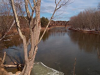
WThe Saco River is a river in northeastern New Hampshire and southwestern Maine in the United States. It drains a rural area of 1,703 square miles (4,410 km2) of forests and farmlands west and southwest of Portland, emptying into the Atlantic Ocean at Saco Bay, 136 miles (219 km) from its source. It supplies drinking water to roughly 250,000 people in thirty-five towns; and historically provided transportation and water power encouraging development of the cities of Biddeford and Saco and the towns of Fryeburg and Hiram. The name "Saco" comes from the Eastern Abenaki word [sɑkohki], meaning "land where the river comes out". The Jesuit Relations, ethnographic documents from the 17th century, refer to the river as Chouacoet.
 W
WThe Cold River is a 16.7-mile-long (26.9 km) river in western Maine in the United States. It very briefly enters New Hampshire as well. It is part of the Saco River drainage basin.
 W
WThe Cutler River is a stream located in the White Mountains of New Hampshire in the United States.
WThe Dry River is a 9.0-mile-long (14.5 km) river in the White Mountains of New Hampshire in the United States. It is a tributary of the Saco River, which flows to the Atlantic Ocean in Maine. For nearly its entire length, it is within the Presidential Range-Dry River Wilderness of the White Mountain National Forest.
 W
WThe East Branch of the Saco River is a 13.2-mile-long (21.2 km) river in the White Mountains of New Hampshire in the United States. It is a tributary of the Saco River, which flows to the Atlantic Ocean in Maine.
WThe East Fork of the East Branch of the Saco River is a 2.2-mile-long (3.5 km) stream in the White Mountains of New Hampshire in the United States. It is a tributary of the East Branch of the Saco River, with its waters ultimately flowing to the Atlantic Ocean in Maine.
 W
WThe Ellis River is a 16.7-mile-long (26.9 km) river in the White Mountains of New Hampshire in the United States. It is a tributary of the Saco River, which flows to the Atlantic Ocean in Maine.
 W
WThe Little Cold River is a 3.9-mile (6.3 km) long river in western Maine in the United States, flowing through the foothills of the White Mountains. It is a tributary of the Cold River, part of the Saco River watershed.
 W
WThe Little Ossipee River is a 33.7-mile-long (54.2 km) tributary of the Saco River in southwestern Maine, USA.
 W
WThe Ossipee River is an 18.3-mile-long (29.5 km) river in eastern New Hampshire and western Maine in the United States. It is a tributary of the Saco River, which flows southeast to the Atlantic Ocean at Saco, Maine.
 W
WPequawket Brook is a 6.4-mile-long (10.3 km) stream near the White Mountains of New Hampshire in the United States. It lies within the watershed of the Saco River, which flows to the Atlantic Ocean in Maine. The brook is under the jurisdiction of the New Hampshire Comprehensive Shoreland Protection Act.
 W
WThe Rocky Branch is a 13.1 mile long river in the White Mountains of New Hampshire in the United States. It is a tributary of the Saco River, which flows to the Atlantic Ocean in Maine.
 W
WThe Skelton Dam is an embankment dam on the Saco River between the towns of Buxton and Dayton in York County, Maine. It is located about 7 mi (11 km) northwest of Saco and Biddeford. The dam was completed in 1948 with the primary purpose of hydroelectric power generation. The largest fish lift in Maine was completed on the dam in 2001. The dam and facilities are owned by Brookfield Renewable.
 W
WThe South River is a 10.6-mile-long (17.1 km) river in eastern New Hampshire and western Maine in the United States. It is a tributary of the Ossipee River, which flows east to the Saco River and ultimately the Atlantic Ocean.
 W
WThe Swift River is a 25.6 miles (41.2 km) river in the White Mountains of New Hampshire in the United States. It is a tributary of the Saco River, which flows to the Atlantic Ocean in Maine.
 W
WThe West Branch is a 5.5-mile (8.9 km) long river located in eastern New Hampshire in the United States. It is the northern tributary of Ossipee Lake, part of the Saco River watershed leading to the Atlantic Ocean.