 W
WThe Barrier Volcano is an active shield volcano located in the north of Kenya. It is last known to have erupted in 1921.
 W
WCentral Island, also known as Crocodile Island, is a volcanic island located in the middle of Lake Turkana in Kenya. It is also the location of Central Island National Park, which is governed by the Kenya Wildlife Service.
 W
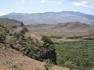
WThe Elementeita Badlands, also known as the Otutu Forest or Ututu Forest, is a lava flow in Kenya that covers approximately 36 square kilometres. The area was previously covered in thick dryland forest characterized by cedar trees,, and Leleshwa bushes. In addition, Wild Jasmine and Boophone are also found.
WEmuruangogolak is an active shield volcano straddling the Gregory Rift in Kenya, in Eastern Africa. It has a 3.5-by-5.0-kilometre caldera on its summit. The last known eruption was a trachyte flow which occurred in 1910. Steam vents and fumarolic activity continues from fissures within the caldera and along the flanks of the volcano. Several maar lakes exist in the rift valley adjacent to the volcano. The volcano's summit is at 1,328 metres (4,357 ft) elevation, and its formation is calculated to have been 38,000 years ago.
 W
WMount Homa is a mountain located in western Kenya. It forms a broad peninsula on the southern shore of Winam Gulf, an extension of Lake Victoria. This peninsula defines Homa Bay and the mountaintop is about 20 kilometres north of the town of that name.
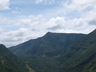
WMount Kipipiri is an isolated volcano in the Wanjohi Valley, on the Kinangop Plateau near to the Aberdare Range. It is about 20 miles (32 km) northeast of Lake Naivasha, which is visible from the summit. Wildlife includes Colobus and Sykes monkeys, elephants and buffalo and abundant birdlife. The name of the mountain means "butterfly" in the Gikuyu language, a reference to its profile from a distance.
WKorosi is a shield volcano located in the Gregory Rift at the northern end of Lake Baringo, Kenya.
 W
WMarsabit is a 6300 km2 basaltic shield volcano in Kenya, located 170 km east of the center of the East African Rift, in Marsabit County near the town of Marsabit. This was primarily built during the Miocene, but some lava flows and explosive maar-forming eruptions have occurred more recently. At least two of the maars host crater lakes.
 W
WMenengai Crater is a massive shield volcano with one of the biggest calderas in the world, in the Great Rift Valley, Kenya. It is the largest volcano caldera in Kenya and the second largest volcano caldera in Africa. Volcanic formed rich loam soils enrich the adjacent farmland arounds its flanks. The crater is on the floor of the Rift Valley. The volcano formed about 200,000 years ago and the prominent 12 x 8 km caldera formed about 8000 years ago. The caldera floor is covered with numerous post caldera lava flows. The Menengai volcano is considered one of the best-preserved Krakatau-style calderas in the world. Menengai has very little sediment in the caldera which is a thick mass of lava boulders and inaccessible ridges. Volcanic activity continues and a current project under the GDC is at an advanced stage towards geothermal power generation.
WMount Kulal is an eroded-down extinct volcano located in northern Kenya, just east of Lake Turkana. The mountain has an elevation of 2,285 metres (7,497 ft). The lakeside town of Loiyangalani is located 50 kilometres (31 mi) west of Mount Kulal.
 W
WNamarunu is a shield volcano located in the Great Rift Valley, Kenya.
 W
WOl Doinyo Eburru is an active complex of volcanoes in the Great Rift Valley, Kenya to the northwest of Lake Naivasha. It is being exploited for geothermal energy. Soysambu Conservancy is located to the north of the massif, between Lake Elmenteita to the east and Lake Nakuru to the west.
 W
WThe Olkaria Area is a region located immediately to the south of Lake Naivasha in the Great Rift Valley of Kenya, Africa. It is geothermally active and is being used to generate clean electric power. The region has an estimated potential of 2,000 MW. This is almost double the maximum daily electricity peak demand recorded in 2008/2009 for the entire country.
WPaka is a shield volcano located in the Great Rift Valley, Kenya. Geothermal activity is widespread at Paka. Paka means "ochre" in Pokot.
WMount Silali is a dormant volcano in the Gregory Rift Valley, near Kapedo, Kenya. Silali is south of the Suguta Valley, which reaches northward to Lake Turkana, and is about 70 kilometres (43 mi) north of Lake Baringo.
 W
WMount Suswa is a shield volcano in the Great Rift Valley, Kenya. It is located between Narok and Nairobi, the capital of Kenya. The northwestern part of Mount Suswa is in Narok County, while the eastern and southern part are in Kajiado County. The town with the same name, Suswa, is just northwest of the mountain and it is the main access point for visits to the mountain.