 W
WThe Alsea River flows 48.5 miles (78.1 km) from Alsea, an unincorporated community in the coastal mountains of the U.S. state of Oregon, to the Pacific Ocean near the city of Waldport. It begins at the confluence of the North Fork Alsea River and the South Fork Alsea River and ends in Alsea Bay, a wide estuary at Waldport. The river flows generally west-northwest in a winding course through the mountains of southern Benton and Lincoln counties, passing near the unincorporated community of Tidewater and through the Siuslaw National Forest. Its drainage basin extends into Lane County, along the headwaters of the South Fork Alsea River.
 W
WThe North Fork Alsea River is a 16-mile (26 km) tributary of the Alsea River in the U.S. state of Oregon. It begins at Klickitat Lake, fed by Klickitat and Lake creeks in the Central Oregon Coast Range, and flows generally south to near Alsea, where it joins the South Fork Alsea River to form the main stem. For most of its course, the North Fork winds through the Siuslaw National Forest in Lincoln County and then Benton County. It passes under Oregon Route 34 northeast of Alsea.
 W
WThe South Fork Alsea River is a tributary of the Alsea River in the U.S. state of Oregon. It begins at northeast of Horton on the east side of the Central Oregon Coast Range and flows generally northwest to near Alsea. There it joins the North Fork Alsea River to form the main stem.
 W
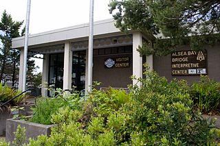
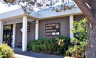
WAlsea Bay Historic Interpretive Center is a public facility in Waldport, Oregon, administered and owned by the city of Waldport. It is adjacent to the Alsea Bay Bridge and was constructed by the Oregon Department of Transportation as part of the bridge replacement project. It was transferred to the city on Oct 8th, 2020 from the Oregon Department of Transportation.
 W
WOregon Route 34 is a state highway in the U.S. state of Oregon that runs between the city of Waldport on the Oregon Coast and the city of Lebanon in the western part of the state. OR 34 traverses the Alsea Highway No. 27 from Waldport to Flynn, part of the Corvallis–Newport Highway No. 33 from Flynn to east of Corvallis, and the Corvallis–Lebanon Highway No. 210 from east of Corvallis to Lebanon, of the Oregon state highway system. In Corvallis, OR 34 includes a brief concurrency with U.S. Route 20 and OR 99W over the Pacific Highway West No. 1W.
 W
WAlsea is an unincorporated community in Benton County, in the U.S. state of Oregon. It is on Oregon Route 34 and the Alsea River. For statistical purposes, the United States Census Bureau has defined Alsea as a census-designated place (CDP). The census definition of the area may not precisely correspond to local understanding of the area with the same name. As of the 2010 Census, the population was 164.
 W
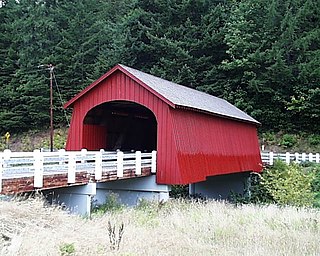
WThe Fisher School Bridge is a covered bridge in Lincoln County in the U.S. state of Oregon. The 72-foot (22 m) Howe truss structure crosses a stream called Five Rivers near the rural community of Fisher in the Central Oregon Coast Range. Closed to vehicles, it is a pedestrian bridge.
WFisher is an unincorporated community in rural Lincoln County, Oregon, United States. Fisher lies along Five Rivers Road, 9.2 miles (14.8 km) south of its intersection with Oregon Route 34. It is slightly north of the Lincoln–Lane county line in the Siuslaw National Forest. A stream called Five Rivers flows west through Fisher, about 12 miles (19 km) by water from the stream's mouth on the Alsea River. Route 34 runs along the Alsea River between Alsea and Waldport.
WFive Rivers is a tributary of the Alsea River in the U.S. state of Oregon, in Lane, Lincoln, Benton counties. The name Five Rivers refers to the relative importance to the stream of five of its tributaries: Alder, Cougar, Buck, Crab, and Cherry creeks.
WThe Green River is a tributary of Five Rivers in the U.S. state of Oregon. It arises in the Siuslaw National Forest of the Central Oregon Coast Range and flows generally northeast to meet Five Rivers upstream of the rural community of Fisher. The confluence is about 15 miles (24 km) from the larger stream's confluence with the Alsea River. The Green River's named tributaries from source to mouth are the East Fork Green River and Ryan Creek.
 W
WHayden Bridge, a Howe truss structure, spans the Alsea River about 2 miles (3 km) west of Alsea, Oregon, United States. Constructed in 1918, the 91-foot (28 m) span is one of only seven remaining covered bridges in Oregon that were built before 1920. Similar spans such as the Mill Creek Bridge crossed the Alsea or one of its tributaries in the same vicinity, but only the Hayden Bridge has survived. It was added to the National Register of Historic Places in 1979.
WThe Red River is a stream approximately 1 mile (2 km) long in Lincoln County in the northwestern U.S. state of Oregon. It rises south of downtown Waldport and flows through the city to meet the Alsea River near the larger river's mouth on the Pacific Ocean.
WSouthworth Creek is a stream, about 5 miles (8 km) long, in Lincoln County, in the U.S. state of Oregon. It is a tributary of the Alsea River, which it enters upstream of Waldport and the Pacific Ocean. It flows north from the slopes of Burnt Timber Mountain to join the larger stream at an elevation of just 7 feet (2.1 m) above sea level.
 W
WTidewater is an unincorporated community in Lincoln County, Oregon, United States located on the Alsea River east of Waldport on Oregon Route 34.
 W
WUSS Alsea (AT-97) was an Abnaki-class of fleet ocean tug. It was named after the Alsea Native American tribe in Oregon.
 W
WW. B. Nelson State Recreation Site is a state park in Lincoln County, western Oregon.
 W
WWaldport is a city in Lincoln County, Oregon, United States. The population was 2,033 at the 2010 census. The city is located on the Alsea River and Alsea Bay, 15 miles (24 km) south of Newport and 8 miles (13 km) north of Yachats.