 W
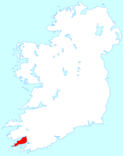
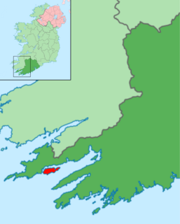
WBeara or the Beara Peninsula is a peninsula on the south-west coast of Ireland, bounded between the Kenmare "river" to the north side and Bantry Bay to the south. It contains two mountain ranges running down its centre: the Caha Mountains and the Slieve Miskish Mountains. The northern part of the peninsula from Kenmare to near Ardgroom is in County Kerry, while the rest forms the barony of Bear in County Cork.
 W
WAdrigole is a village situated on the Beara Peninsula in County Cork, in Ireland. It is centred on the junction of the R572 and R574 regional roads. The electoral division in which the village sits has a sparsely distributed population of about 450 people.
 W
WAllihies is a townland in the civil parish of Kilnamanagh, in County Cork, Ireland. The townland of Allihies is located at the western tip of the Beara Peninsula.
 W
WArdgroom is a village on the Beara peninsula in County Cork, Ireland. Its name refers to two gravelly hills deposited by a glacier, Dromárd and Drombeg. It lies to the north north west of Glenbeg Lough, overlooking the Kenmare River estuary. It sits between the coast and the Slieve Miskish Mountains. The village contains a shop, post office, a petrol station and "The Village Inn" pub.
 W
WBere Island (Irish: Oiléan Béarra, meaning "bear island", although officially called An tOileán Mór meaning "the big island") is an island off the Beara Peninsula in County Cork, Ireland. It is roughly 10 km x 3 km in dimension, with an area of 17.68 km², and, as of 2012, had a population of between 210 and 220 people.
 W
WThe Caha Mountains are a range of low sandstone mountains situated on the Beara peninsula in south-west County Cork, in Ireland. The highest peak is Hungry Hill, 685 m (2,247 ft) tall. Other notable peaks include Knocknagree, Sugarloaf Mountain, Eskatarriff, Knocknaveacal, Derryclancy, Nareera, Killane Mountain and Baurearagh Mountain.
 W
WCastletownbere is a town in County Cork in Ireland. It is located on the Beara Peninsula by Berehaven Harbour. It is also known as Castletown Berehaven.
 W
WDunboy Castle is a ruined castle on the Beara Peninsula in south-west Ireland near the town of Castletownbere. It was a stronghold of the O'Sullivan Bere, a Gaelic clan leader and 'Chief of Dunboy', and was built to guard and defend the harbour of Berehaven. Its presence enabled O'Sullivan Bere to control the sea fisheries off the Irish coast and collect taxes from Irish and continental European fishing vessels sheltering in the haven. It was also a centre for the import/export trade to and from the continent. Today, much of the castle is destroyed but the ruins are open to the public.
 W
WDursey Island lies at the southwestern tip of the Beara Peninsula in the west of County Cork in Ireland. Dursey Island is 6.5 kilometres long and 1.5 kilometres wide. The island is separated from the mainland by a narrow stretch of water, Dursey Sound, which has a very strong tidal race, with the submerged Flag Rock close to the centre of the channel. The island has just six or so permanent residents, and is connected to the mainland by Ireland's only cable car. Dursey has no shops, pubs or restaurants. At one point there was a post office on the island; this has since closed.
 W
WEyeries is a village and its hinterland, on the Beara Peninsula in County Cork, Ireland, near the border with County Kerry. It lies at the foot of a hilly area, with a beach nearby, and is home to several retail and tourist businesses.
 W
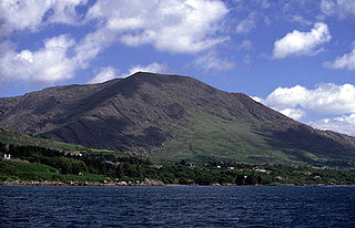
WHungry Hill is a mountain on the Beara Peninsula, County Cork, in the Republic of Ireland.
 W
WHungry Hill is a novel by prolific British author Daphne du Maurier, published in 1943. It was her seventh novel. There have been 33 editions of the book printed.
 W
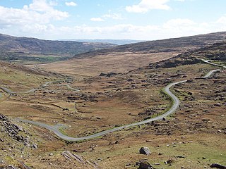
WThe R574 is an Irish regional road in the Beara peninsula which crosses the Caha Mountains via the (Tim) Healy Pass. It runs from the R572 at Adrigole in County Cork to the R571 near Lauragh in County Kerry. It is a popular tourist route with the pass at an altitude of 300m giving panoramas towards Bantry Bay to the south-east and the Kenmare River to the north-west.
 W
WRerrin is the name of the main village on Bere Island, within County Cork. The village is located on the north of the island and is next to the sheltered mooring of Lawrence Cove. It is also the name of the townland surrounding the village. Historical records list Rurryne in the Calendar of Patent Rolls of James I dated 1611.
WThe Siege of Dunboy took place at Dunboy Castle between 5 June and 18 June 1602, during the Nine Years' War in Ireland. It was one of the last battles of the war. An English army of up to 5,000 under George Carew besieged the castle, which was held by a Gaelic Irish force of 143 loyal to Donal Cam O'Sullivan Beare. The English took the castle after eleven days and most of the survivors were hanged. The English also captured a fort on nearby Dursey Island.
 W
WThe Slieve Miskish Mountains are a small range of low sandstone mountains found at the extreme south-western tip of the Beara Peninsula of County Cork in Ireland. The name derives from the Irish "Sliabh Mioscais," "the Mountains of Malice." Unlike the Caha Mountains, which lie further north on the peninsula, the Slieve Miskish Mountains lie entirely on the Cork side of the peninsula, part of which belongs to County Kerry. There are only four named mountain peaks in the range: Knocknagallaun, 376 m; Knockgour, 481 m; Knockoura, 490 m; and Miskish Mountain, 386 m. They overshadow the main town on the peninsula, Castletownbere, as well as the village of Allihies on their western slope, which was once the centre of a thriving copper mining industry in the 19th century. The now-abandoned mines and surrounding buildings can still be seen on the mountain slopes above Allihies.
 W
WSugarloaf Mountain is a mountain south-west of Glengarriff in County Cork, Ireland.