 W
WAborrebjerg is a hill on the Danish island of Møn.
 W
WThe Baltic Uplands is a chain of morainic hills about 200 kilometres (120 mi) wide that border the southern Baltic Sea from Jutland to Estonia.
 W
WBolbro Hill is a hill in the western part of the Bolbro District in Odense, Denmark. It was the location of the famous Odinstårnet (Odin Tower) from 1935 to 1944.
 W
WBovbjerg is an up to 41 meter high coastal hill south of the village Ferring in Western Jutland, Denmark. It is known for its lighthouse, Bovbjerg Fyr, and its beach, Bovbjerg Strand.
 W
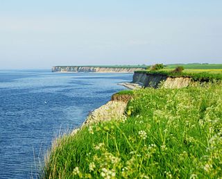
WThe Cliffs of Sangstrup and Karlby in Denmark, Northern Europe, at the entrance to the Baltic Sea, are two, up to 17 meters tall, and 5 km long coastal limestone cliffs originating from a 65-million-year-old coral reef in a prehistoric and tropical Danish sea. Today the climate in Denmark is coastal temperate.
 W
WEjer Bavnehøj is the third-highest natural point in Denmark.
 W
WFrøbjerg Bavnehøj is 131 metres (430 ft) above sealevel and is the highest natural point on the island of Funen.
 W
WGyldenløves Høj is a high point on Sjælland, used to be though the highest at 125.5 m above mean sea level. Kobanke near Rønnede is the highest natural point, however, at 122.9 m, as Gyldenløves Høj is only 121.3 m without the artificial mound constructed at the summit.
 W
WHasle Hills is a landscape and recreational area of 15.5 hectares in Aarhus, Denmark. It is located in the borderland between Hasle and the neighbourhood of Gellerup in the district of Aarhus V in the western parts of the city. Hasle Hills is part of the nature protection area of Naturen på Holmstrup Mark, which also contains parts of the larger recreational area of Skjoldhøjkilen, stretching west from Hasle Hills.
 W
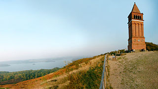
WHimmelbjerget is a hill located between Ry and Silkeborg, Denmark in the area known as Søhøjlandet.
 W
WJernhatten - The Iron Hat - is a protected hill and view point on the peninsula, Djursland, in Denmark protruding into the sea, Kattegat between Denmark and Sweden. From the top of the hill, 49 meters above sea level, there is a view up and down the coast including and the island Hjelm as well as an inland view over the hilly southern Djursland area, called Mols.
 W
WMøllehøj is the highest natural point in Denmark at 170.86 m (561 ft).
 W
WRytterknægten is the highest point on the Danish island of Bornholm at 162 metres (531 ft) above sea level. The bierg is situated on a wooded bedrock of gaiter formations in the middle of Almindingen forest. Aakirkeby is located about 5 kilometres (3.1 mi) to the southeast.
 W
WSkamlingsbanken is a large hill located in Vejstrup Parish, Jutland, Denmark, between Kolding and Christiansfeld. With a peak rising to 113 metres (371 ft) above sea level, it is the highest point in Southern Jutland.
 W
WStabelhøje or Stabel Høje are two Bronze Age Mounds 135 meters and 133 meters above sea level by the village Agri in Mols Bjerge on the peninsula Djursland in Denmark at the entrance to The Baltic Sea in Northern Europe. The burial mounds date back to the early Bronze Ages 1800–1000 years B.C. These hills are some of the more known view points in Mols Bjerge National Park. Other view points in the area are Agri Baunehøj, Trehøje, Ellemandsbjerg and Jernhatten.
 W
WTrehøje is a Danish vista point with a view of the sea to the east, south and west, located in the Mols Bjerge National Park on the peninsula Djursland between Denmark and Sweden. Three large bronze-age barrows close to each other 127 meters above the sea, have given their name to the place, which contains a group of 22 barrows. "Trehøje" meaning three mounds, is one of four major vista points in the hills of Mols, each with a barrow on top. The others are Ellemandsbjerg, Stabelhøje and Agri Baunehøj.
 W
WYding Skovhøj in Horsens municipality, Jutland is one of Denmark's highest points.