 W
WThe 1872 California-Nevada State Boundary Marker marks the initial point for the 1872 survey delineation of the state line between California and Nevada. It is listed in the National Register of Historic Places.
 W
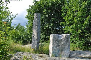
WThe Von Schmidt State Boundary Monument was designated a California Historic Landmark (No.859) on April 26, 1973. In 1873 San Francisco civil engineer Allexey W. Von Schmidt built the State Boundary Monument in San Bernardino County, California near Needles, California. In 1872 and 1873 Von Schmidt did a survey of the border between California and Nevada/Arizona. The California Historic marker is on the dirt road, Pew Road, also called River Road, 2.6 Miles South of the State Line; 14 Miles North of Needles. The marker is not at the current state boundary, as Von Schmidt made an error in his survey. A new survey in 1893 showed that the Von Schmidt line was 1,600 to 1,800 feet off to the west. The marker is at the southern end of the California-Arizona State boundary. In 1872, a dispute arose between Nevada and California about the location of the state's boundary. Nevada wanted the state divide to be the same as the Sierra Nevada mountain range divide. California wanted the line to the east of the mountain range. When California attained statehood in 1850, it adopted 120 degrees west longitude as its eastern border. Between 1855 and 1900 there were six surveys to locate 120 degrees, with each locating 120 degrees of longitude differently. Von Schmidt applied for and was granted the contract to survey the state's frontier border east of the Sierra Nevada. In 1872 Von Schmidt using only a compass, a sextant and dead reckoning process set out with his crew to define the boundary. Von Schmidt was charged to measure and mark the boundary. Von Schmidt and his crew built stone markers and installed cast iron markers about one mile apart on the length of the state's boundary. Not many of the markers had foundations, so fewer remain today. A new survey in 1893 showed that the Von Schmidt line was 1,600 to 1,800 feet west of the actual 120 degrees. However, California and Nevada both recognize the 1872 Von Schmidt survey and the 1893 survey as the state line. Later the 1893 line was used. The exact location of the north-south California-Nevada border, between Lake Tahoe and the intersection of the southern boundary of Oregon at the 42nd parallel, was contentious and was surveyed and re-surveyed many time. One of the few iron markers that has survived is a near Verdi, Nevada this is a National Historic Landmark called the 1872 California-Nevada State Boundary Marker.
 W
WThe Beginning Point of the U.S. Public Land Survey is the point from which the United States in 1786 began the formal survey of the lands known then as the Northwest Territory, now making up all or part of Ohio, Indiana, Illinois, Michigan, and Wisconsin. The survey is claimed to be the first major cadastral survey undertaken by any nation. The point now lies underwater on the state line between Ohio and Pennsylvania. Because it is submerged, a monument commemorating the point is located on the state line between East Liverpool, Ohio and Ohioville, Pennsylvania, adjacent to the nearest roadway. The area around the marker was designated a National Historic Landmark in 1965.
 W
WThe boundary markers of the original District of Columbia are the 40 milestones that marked the four lines forming the boundaries between the states of Maryland and Virginia and the square of 100 square miles (259 km²) of federal territory that became the District of Columbia in 1801. Working under the supervision of three commissioners that President George Washington had appointed in 1790 in accordance with the federal Residence Act, a surveying team that Major Andrew Ellicott led placed these markers in 1791 and 1792. Among Ellicott's assistants were his brothers Joseph and Benjamin Ellicott, Isaac Roberdeau, George Fenwick, Isaac Briggs and an African American astronomer, Benjamin Banneker.
 W
WThe Calais Observatory is a pair of granite fixtures in Meridian Park in Calais, Maine. The two stones were used for mounting scientific equipment used in a variety of astronomical observations, principally for the accurate calculation by the United States Coast Survey of Calais's longitude with respect to meridians in Cambridge, Massachusetts, and Greenwich, England. The site was listed on the National Register of Historic Places in 2012, and is part of the National Oceanic and Atmospheric Administration's Heritage Trail program. At the time of its longitude determination in 1866 with respect to the Greenwich Meridian, it was arguably one of the most precisely located places in the United States.
 W
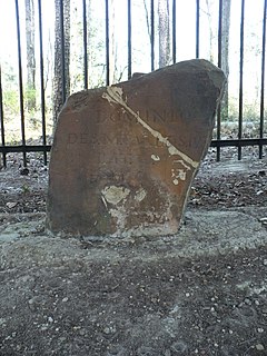
WEllicott's Stone, also known as the Ellicott Stone, is a boundary marker in northern Mobile County, Alabama. It was placed on April 10, 1799 by a joint U.S.-Spanish survey party headed by Andrew Ellicott. It was added to the National Register of Historic Places on April 11, 1973.
 W
WFairfax Stone Historical Monument State Park is a West Virginia state park commemorating the Fairfax Stone, a surveyor's marker and boundary stone at the source of the North Branch of the Potomac River. The original stone was placed on October 23, 1746 to settle a boundary dispute between Thomas Fairfax, 6th Lord Fairfax of Cameron and the English Privy Council concerning the Northern Neck of Virginia. It determined the proprietorship and boundaries of a large tract of mostly unsurveyed land in the English colonies of Maryland and Virginia.
 W
WThe Gila and Salt River Meridian intersects the initial point on the south side of the Gila River, opposite the mouth of Salt River, at latitude 33° 22′ 37.82733″ north, longitude 112° 18′ 21.99931″ west from Greenwich based on NAD 83, and governs the surveys in the territory of Arizona. The current declination for the initial point is 12° east. It is located on Monument Hill, an easily visible hill just south of the confluence of the Gila and Salt Rivers, in Avondale, Arizona, about 14 miles southwest of downtown Phoenix. The original marker was set in 1851 by John R. Bartlett. In 1934, the U.S. Coast and Geodetic Survey set triangulation station "INITIAL" approximately 15 feet from the initial point. Ty White, Associate Cadastral Engineer for the U.S. Bureau of Land Management (BLM), re-monumented the initial point on December 1, 1944. On April 24,1962, the monument was re-established by Leonard W. Murphy, based on the Ty White's field notes, because the previous monument had been vandalized. On April 26, 1984, Paul L. Reeves and John P. Bennet re-monumented the original corner. On February 19, 2006, the initial point was again re-monumented due to deterioration of the 1985 plaque. This re-monumentation was performed by staff from the BLM, members of the Arizona Professional Surveyors Society, and students at Phoenix College. The initial point was added to the National Register of Historic Places as of October 15, 2002. The plaque for that listing was installed as part of the 2006 re-monumenting.
 W
WThe Illinois–Indiana State Line Boundary Marker is a sandstone boundary marker obelisk located near the end of Chicago's Avenue G, just west of the State Line Generating Plant of Hammond, Indiana. Since 1988 it has been 159.359 miles (256.463 km) north of the Wabash River.
 W
WIron Post is a historic boundary marker located in New Albin, Iowa, United States. An Act of Congress on March 3, 1849 sought to resolve the boundary issue between the State of Iowa and the newly established Minnesota Territory. This cast iron post was placed here by Captain Thomas Lee of the U.S. Army Corps of Topographical Engineers. He determined that North latitude 43 degrees, 30 minutes was indeed the border between the two entities, which the United States Congress had designated on August 4, 1846 as Iowa's northern border. It also served as a correction for the townships that had been established below the line, and as a practical surveying base for the territory to the north from this point all the way to the Big Sioux River.
 W
WThe Louisiana Purchase Historic State Park commemorates the initial point from which the lands acquired through the Louisiana Purchase (1803) were subsequently surveyed. The protected area encompasses 37.5 acres (15.2 ha) of forested wetlands, a landform which is regionally in decline due to agricultural development practices that include draining such areas. In the center of the park is a 6-foot (1.8 m) marker erected in 1926 on the survey point by the L'Anguille Chapter of the Daughters of the American Revolution. The site was listed on the National Register of Historic Places (1972) and designated as a National Historic Landmark (1993).
 W
WMason and Dixon Survey Terminal Point is a historic marker located near Pentress, West Virginia, United States. Located on the boundary between Monongalia County, West Virginia and Greene County, Pennsylvania, it identifies the terminal station established by Charles Mason and Jeremiah Dixon on Brown's Hill on October 19, 1767. The stone placed on Brown's Hill in 1883 in the mound of 1767, marks the westernmost point reached by Mason and Dixon in delineating the common boundaries of Pennsylvania, Maryland, Delaware, and Virginia, and known as the Mason–Dixon line.
 W
WThe Mason and Dixon West Line Milestone Markers 76 and 77 are historic objects located in Frederick County, Maryland and Adams County, Pennsylvania, United States, near the community of Harney, Maryland. They are two of the original milestones that mark the Mason-Dixon line between the states of Maryland and Pennsylvania. Oolite limestone was quarried and carved on the Isle of Portland in the English Channel. Both were part of the third shipment of milestones and they arrived in Baltimore in June 1767. Stones from this shipment were placed in 1767 to mark mile 64 and miles 66 through 132 on the West Line. Both of these sites were surveyed on August 24, 1765. Milestone 76 was set on October 13, 1767. Milestone 77 was set the following day 125 yards (114 m) to the east of its true location, which is in the middle of Marsh Creek. It is one of two milestones intentionally offset due to the challenges of its true location.
 W
WSeven Ranges Terminus is a stone surveying marker near Magnolia, Ohio that marks the completion of the first step in opening the lands northwest of the Ohio River to sale and settlement by Americans. This survey marked the first application of the rectangular plan for subdividing land.
 W
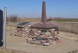
WSite No. JF00-072 is a survey monument located at the quadripoint of Republic and Washington counties in Kansas and Jefferson and Thayer counties in Nebraska. The monument marks the intersection of the sixth principal meridian and its baseline, the 40th parallel north; it serves as the initial point of all land surveys in Kansas and Nebraska, as well as most of Wyoming and Colorado, and part of South Dakota. The original sandstone monument was 6 feet (1.8 m) tall. U.S. Deputy Surveyor Charles A. Manners set the monument in 1856. The monument was later buried under a county roadbed; it was unearthed and reburied twice before being dug up for good in 1986, though its middle section is now missing.
 W
WSite No. RH00-062 is a survey monument located at the tripoint of Richardson County, Nebraska, and Brown and Doniphan counties in Kansas. The cast iron monument is 6 feet (1.8 m) tall and 16 inches (410 mm) square at its base. The monument marks the starting point of the land survey of the Kansas-Nebraska border along the 40th parallel north, which intersects the top of the Missouri River's western bluff at this spot. U.S. Deputy Surveyor Charles A. Manners erected the monument in 1855 at the beginning of the survey. In 1924, the monument was displaced and reset at the wrong location before Leo M. Petersen reset it in a sturdier base.
 W
WThe Willamette Stone was a small stone obelisk originally installed by the Department of Interior in 1885 in the western hills of Portland, Oregon in the United States to mark the intersection and origin of the Willamette meridian and Willamette baseline. It replaced a cedar stake placed by the Surveyor General of the Oregon Territory in 1851; this stake defined the grid system of sections and townships from which all real property in the states of Oregon and Washington has been measured following the Donation Land Claim Act of 1850. The Willamette meridian runs north–south, and the Willamette baseline runs east–west through the marker. The easternmost northeast corner of Washington County is sited on the marker.