 W
WThe Boca Paila Peninsula, also known as Sian Ka'an, is on the southern Yucatán Peninsula coast, within Tulum municipality of the state of Quintana Roo in southeastern Mexico.
 W
WCabo Catoche or Cape Catoche, in the Mexican state of Quintana Roo, is the northernmost point on the Yucatán Peninsula. It lies in the municipality of Isla Mujeres, about 53 km (33 mi) north of the city of Cancún. According to the International Hydrographic Organization, it marks the division point between the Caribbean Sea to the east and Gulf of Mexico to the west.
 W
WChetumal Bay is a large bay of the western Caribbean Sea on the southern coast of the Yucatán Peninsula.
 W
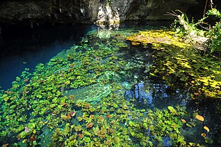
WChoo-Ha, Tamcach-Ha and Multun-Ha are a series of small cenotes close to the Mayan site of Cobá in central Yucatán Peninsula. All of them are accessible to the public for swimming. Choo-Ha has a small entrance of only about 3 by 4 meters.
 W
WThe Coba Lake or Lake Coba is an almost circular lake close to the ancient Maya city of Coba on the Yucatán peninsula.
 W
WThe Gulf of Mexico is an ocean basin and a marginal sea of the Atlantic Ocean, largely surrounded by the North American continent. It is bounded on the northeast, north and northwest by the Gulf Coast of the United States, on the southwest and south by the Mexican states of Tamaulipas, Veracruz, Tabasco, Campeche, Yucatan, and Quintana Roo, and on the southeast by Cuba. The US states of Texas, Louisiana, Mississippi, Alabama, and Florida border the Gulf on the north, which are often referred to as the "Third Coast", in comparison with the U.S. Atlantic and Pacific coasts.
 W
WLake Bacalar is a long and narrow lake in the state of Quintana Roo, Mexico. It is approximately 42 km long measured from north to south, and less than 2 km at its widest. The lake is renowned for its striking blue color and water clarity, partly the result of having a white limestone bottom. Like most bodies of water in the Yucatán peninsula, the lake is fed by underground rivers, whose regular open pools are cenotes. Because of the porous limestone, the Yucatan Peninsula has almost no lakes, this is by far the largest, and fed by the 450 km underground river that is part of the worlds's largest water cave/tunnel system, paralleling the coast.
 W
WLake Chichancanab from Yucatec Maya "Little Sea" is a lake in Mexico located in the northwest of the state of Quintana Roo, in the municipality of José María Morelos. It is also known as Laguna Chichancanab, Laguna Chicnancanab and Laguna de Chichancanab. It has an approximate length of 30 kilometers from near the settlement of La Presumida to that of Kantemó, in the same municipality. It is the largest lake on the Yucatan Peninsula.
 W
WPalancar Reef is a large coral reef on the southwest side of the island of Cozumel and is part of the Arrecifes de Cozumel National Park. The site, popular with scuba divers, is divided into several sections based on depth and coral formations. Dive depths range from 50 to 110 feet, with coral swim-throughs in many places.
 W
WPunta Maroma is a beach located in Mexico's easternmost state, Quintana Roo, on the Yucatán Peninsula. The beach of Punta Maroma faces the Caribbean Sea.
 W
WPunta Sur marks the southern point of Cozumel and is part of the Parque Punta Sur, a 247-acre (1.00 km2) ecological park that covers the reefs, beaches, lagoons, and low forest of the surrounding area. The reef system is also part of the Arrecifes de Cozumel National Park.
 W
WDos Ojos is part of a flooded cave system located north of Tulum, on the Caribbean coast of the Yucatán Peninsula, in the state of Quintana Roo, Mexico. The exploration of Dos Ojos began in 1987 and still continues. The surveyed extent of the cave system is 82 kilometers (51 mi) and there are 28 known sinkhole entrances, which are locally called cenotes. In January 2018, a connection was found between Sistema Dos Ojos and Sistema Sac Actun. The smaller Dos Ojos became a part of Sac Actun, making the Sistema Sac Actun the longest known underwater cave system in the world.
WSistema Nohoch Nah Chich, is located 16.5 kilometers (10.3 mi) south of Akumal in Tulum Municipality of Quintana Roo state, southeastern Mexico. It is part of the Sistema Sac Actun underwater cave systems.
WSistema Ox Bel Ha is a cave system in Quintana Roo, Mexico. It is the longest explored underwater cave in the world and ranks fourth including dry caves. As of May 2017 the surveyed length is 270.2 kilometers (167.9 mi) of underwater passages. There are more than 140 cenotes in the system.
 W
WSistema Sac Actun is an underwater cave system situated along the Caribbean coast of the Yucatán Peninsula with passages to the north and west of the village of Tulum. Discovery of a connection to the Sistema Dos Ojos in 2008 made it the longest known underwater cave system.
 W
WXelha is an archaeological site of the Maya civilization from pre-Columbian Mesoamerica, located on the eastern coastline of the Yucatán Peninsula, in the present-day state of Quintana Roo, Mexico. The etymology of the site's name comes from Yukatek Maya, combining the roots xel ("spring") and ha' ("water").
 W
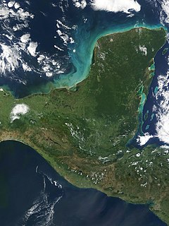
WThe Yucatán Peninsula, in southeastern Mexico, separates the Caribbean Sea from the Gulf of Mexico, with the northern coastline on the Yucatán Channel. The peninsula lies east of the Isthmus of Tehuantepec, a northeastern geographic partition separating the region of Central America from the rest of North America. It is approximately 181,000 km2 (70,000 sq mi) in area, and is almost entirely composed of limestone.