 W
WThe Ak-Buura is a river in Kyrgyzstan and Uzbekistan. It flows through the city Osh, and discharges into the Shahrixonsoy, one of the canals of the Fergana Valley. The river is formed at the north slopes of Alai Mountains. The river is 148 kilometres (92 mi) long, and the watershed covers 2,530 square kilometres (980 sq mi). The long-term average discharge of the river at Tuleyken gauging post is 21.4 cubic metres per second (760 cu ft/s), high-water discharge (June–July) ranging from 50 cubic metres per second (1,800 cu ft/s) to 67 cubic metres per second (2,400 cu ft/s) and low-water discharge (January) from 5 cubic metres per second (180 cu ft/s) to 6 cubic metres per second (210 cu ft/s).
 W
WThe Aksarsoy is a river in the northeast area of Tashkent Region, Uzbekistan. It originates in the Pskem Range of the Tianshan Mountains and flows into the river Pskem, at the bridge over the Pskem near the water level of Lake Charvak.
 W
WThe Amu Darya is a major river in Central Asia and Afghanistan. Rising in the Pamir Mountains, north of the Hindu Kush, the Amu Darya is formed by the junction of the Vakhsh and Panj rivers, in the Tigrovaya Balka Nature Reserve on the border between Afghanistan and Tajikistan, and flows from there north-westwards into the southern remnants of the Aral Sea. In its upper course, the river forms part of Afghanistan's northern border with Tajikistan, Uzbekistan, and Turkmenistan. In ancient history, the river was regarded as the boundary of Greater Iran with "Turan", which roughly corresponded to present-day Central Asia.
 W
WThe Angren, also known as Achangaran, is a river in Tashkent Region of Uzbekistan. The river is 223 kilometres (139 mi) long and has a basin area of 5,260 square kilometres (2,030 sq mi). It flows through the town of Angren. The Angren is a right tributary of the Syr Darya.
 W
WThe Chatkal is a river of Jalal-Abad Region, Kyrgyzstan and Tashkent Region in Uzbekistan. It is the left source river of the Chirchiq in the Syr Darya basin.
 W
WThe Chirchiq or Chirchik is a river of Uzbekistan, a major right tributary of the Syr Darya. It is 155 kilometres (96 mi) in length and its basin has an area of 14,900 square kilometres (5,800 sq mi). The principal tributary is the Ugom (right).
 W
WThe Great Fergana Canal is an irrigation canal located on the Fergana Valley between Uzbekistan and Tajikistan in Central Asia. The project was constructed in 1939 by 160,000 Uzbek and Tajik collective farm workers from the former Soviet Union and was completed in forty-five days. The canal is 270 kilometers long with over 1,000 hydrotechnical plants located along the waterway, 50 of which are known to be significantly important.
 W
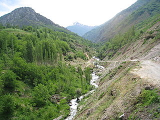
WThe Kara Darya or Qaradaryo is a tributary of the Syr Darya in Kyrgyzstan and eastern Uzbekistan. The river is formed by the confluence of the rivers Kara-Kulja and Tar. Its length is 177 kilometres (110 mi), and watershed area 30,100 square kilometres (11,600 sq mi). The upper Kara Darya flows northwest across eastern Osh Region southwest of and parallel to the Fergana Range. It enters the Ferghana Valley and Uzbek territory a few kilometres west of Uzgen at Andijan Dam. The lower course is through the Fergana Valley, where it is used for irrigation. In the Fergana Valley its confluence with the Naryn River forms the Syr Darya, the second largest river of Central Asia. There are several dams on the river.
 W
WThe Keles is a river of southern Kazakhstan and for a short stretch near the town Keles also in Uzbekistan. It is a right tributary of the Syr Darya. It is 241 kilometres (150 mi) long, and has a drainage basin of 3,310 square kilometres (1,280 sq mi).
 W
WThe Kofarnihon is one of the major tributaries of the Amu Darya in Tajikistan. The river is 387 kilometres (240 mi) long and has a basin area of 11,600 square kilometres (4,500 sq mi). It rises on the southern slopes of Gissar Range in Vahdat district, formerly Kofarnihon district, and flows in the general south-western direction past the cities of Vahdat and Dushanbe, where it turns south and runs through Khatlon Province toward the border with Afghanistan. It falls into Amudarya some 40 km west of the confluence point of Vakhsh and Panj rivers. The Kofarnihon is an important source of drinking water, and yet it is highly polluted by irrigation runoff and inadequately cleaned recycled water around the cities of Dushanbe and Vahdat.
 W
WThe Naryn rises in the Tian Shan mountains in Kyrgyzstan, Central Asia, flowing west through the Fergana Valley into Uzbekistan. Here it merges with the Kara Darya to form the Syr Darya. It is 807 kilometres (501 mi) long and its basin area is 59,100 square kilometres (22,800 sq mi). It has an annual flow of 13.7 cubic kilometres (11,100,000 acre⋅ft).
 W
WThe Pskem or Piskom is a river of Tashkent Region in Uzbekistan in the Pskem Mountains.
 W
WThe Qashqadaryo or Kashkadarya is a river in southern Uzbekistan. The river is 378 kilometres (235 mi) long and has a basin area of 8,780 square kilometres (3,390 sq mi). It disappears in the Qarshi Steppe.
 W
WThe Sherobod, Sherabad or Sheroboddaryo is a right tributary of the Amu Darya in the Surxondaryo Region, southern Uzbekistan. It is about 177 kilometres (110 mi) long and drains an area of 2,950 square kilometres (1,140 sq mi). The river rises in the arid foothills of the Gissar Range and flows south through steppe before flowing through a mountain ridge to empty into the Central Asian plain near the city Sherobod. The river turns south and flows past Qorasuv, to flow into the Amu Darya near the village Shurab. Because of irrigation water use, most of the water in the Sherabad no longer reaches the Amu Darya and its eventual destination in the Aral Sea. After flowing out of the mountains the remaining water in the river is usually salty so it is unsuitable for further water use. In dry years, most of the river dries up before reaching the Amu Darya.
 W
WThe Surxondaryo or Surkhandarya is a primary right tributary of the Amu Darya in Uzbekistan. It is formed at the confluence of the rivers Karatag and Toʻpolondaryo near the city Denov. It flows into the Amu Darya in the city Termez. The river is 175 kilometres (109 mi) long and has a basin area of 13,500 square kilometres (5,200 sq mi).
 W
WThe Syr Darya, historically known as the Jaxartes, is a river in Central Asia. The name, a borrowing from the Persian language, literally means Syr Sea or Syr River, and sometimes it is referred to in this way. It originates in the Tian Shan Mountains in Kyrgyzstan and eastern Uzbekistan and flows for 2,256.25 kilometres (1,401.97 mi) west and north-west through Uzbekistan and southern Kazakhstan to the northern remnants of the Aral Sea. It is the northern and eastern of the two main rivers in the endorrheic basin of the Aral Sea, the other being the Amu Darya (Jayhun). In the Soviet era, extensive irrigation projects were constructed around both rivers, diverting their water into farmland and causing, during the post-Soviet era, the virtual disappearance of the Aral Sea, once the world's fourth-largest lake. The point at which the river flows from Tajikistan into Uzbekistan is, at 300 m (980 ft) above sea level, the lowest elevation in Tajikistan.
 W
WThe Zeravshan is a river in Tajikistan and Uzbekistan, Central Asia. Its name, "spreader of gold" in Persian, refers to the presence of gold-bearing sands in the upper reaches of the river. To the ancient Greeks it was known as the Polytimetus. It was also formerly known as Sughd River. The river is 877 kilometres (545 mi) long and has a basin area of 17,700 square kilometres (6,800 sq mi).