 W
WThe Cleaver Bank is a sandbank in the North Sea about 160 kilometres off the west coast of the Netherlands and south of the Dogger Bank. The size of the bank is about 1235 km2. The bank is 30-40 metres below sea level.
 W
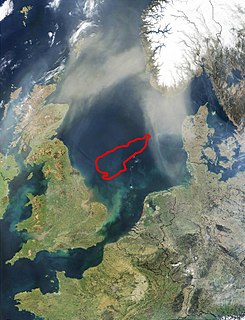
WDogger Bank is a large sandbank in a shallow area of the North Sea about 100 kilometres (62 mi) off the east coast of England.
 W
WEngelsmanplaat, or De Kalkman which is its local name, is a small sandbank between the Dutch islands Ameland and Schiermonnikoog.
 W
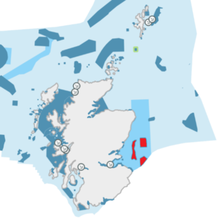
WThe name Firth of Forth Banks Complex refers to a complex of sand and gravel sea banks in the North Sea, lying at the mouth of the Firth of Forth in the seas off the east coast of Scotland. From south to north the banks are named the Berwick Bank, the Scalp Bank, the Wee Bankie and the Montrose Bank. Since 2014 the banks have been protected as a single Nature Conservation Marine Protected Area, which comprises three discrete zones covering a total area of 213,000 hectares (2,130 km2) of Scottish Offshore Waters.
 W
WThe Fisher Bank is a sand bank in the North Sea, off the west coast of Denmark. It consists of Great Fisher Bank, and Little Fisher Bank. Some older charts refer to them as the "Great Fishing Bank" and the "Little Fishing Bank". As Fisher it gives its name to one of the sea areas in the British Shipping Forecast.
 W
WThe Großer Knechtsand is a large sandbank beyond the Weser and Elbe estuaries in the eastern part of Lower Saxony's Wadden Sea off the coast of North Germany. It lies between the islands of Mellum and Neuwerk. The central area of the sandbank lies above the high water mark, forming the Hochsand of Hoher Knechtsand, which was formerly an island. The Hochsand lies 11 km west of the village of Berensch on the nearest part of the mainland in the borough of Cuxhaven in the Land Wursten.
 W
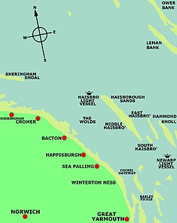
WHaisborough Sands is a sandbank off the coast of Norfolk, England at Happisburgh. The shoal is 10 miles (16 km) long and 1 mile (1.6 km) wide and lies parallel to the North east coast of Norfolk. The shoal is marked to the north-west by north by the Haisbro Light Buoy, North cardinal. To the south-east by south is a light buoy South cardinal, and to the west by Mid Haisbro light buoy starboard hand. In 1995 there were three drying patches recorded to the north-north east and east-south east of the Mid Haisbro light buoy. Except at slack water their positions are indicated by tidal eddies particularly on the north west, and in slight or moderate seas the swell breaks on the shallower parts of the banks. There are several foul patches on the southern part of the shoal. Over the years this shoal has claimed many ships.
WHammond's Knoll is a 6-mile (9.7 km) long sandbank off the coast of Norfolk, England at Happisburgh, to the east of Haisborough Sands. The sandbank at low tide has a depth of 6 fathoms (11 m) at each end, and 3 fathoms (5.5 m) in the centre. The sandbank has lighted buoys at its north and east ends.
 W
WThe Kachelotplate is a sandbar in the North Sea. It lies near the German coast, west of the island of Juist. Since 2003, enough stays above high tide that it can be called an island. Grass and dunes are settling there.
 W
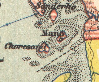
WKoresand is a sandbank in the Danish part of the Wadden Sea, south west of the island of Mandø. There was at least one settlement on Koresand until the frequent storm tides during the 1900s led to its being abandoned. In summer it is possible to travel from Mandø to Koresand by a tractor-drawn wagon.
 W
WThe Maplin Sands are mudflats on the northern bank of the Thames estuary, off Foulness Island, near Southend-on-Sea in Essex, England, though they actually lie within the neighbouring borough of Rochford. They form a part of the Essex Estuaries Special Area of Conservation due to their value for nature conservation, with a large colony of dwarf eelgrass and associated animal communities.
 W
WThe Nore is a sandbank at the mouth of the Thames Estuary, England. It marks the point where the River Thames meets the North Sea, roughly halfway between Havengore Creek in Essex and Warden Point on the Isle of Sheppey in Kent.
 W
WRichel, or rather De Richel, is a permanently dry sandbank in the Wadden Sea, in the gap between the Dutch islands of Vlieland and Terschelling. It is located about 1 kilometer east of the northernmost point of Vlieland and is administered by the municipality of Vlieland. The sandbank has an average surface area of 116 hectares. It is completely flooded only during extremely high tides.
 W
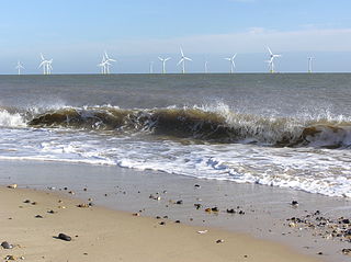
WScroby Sands is a sandbank or shoal, off the coast of Norfolk, England which runs near shore, north to south from Caister south towards Great Yarmouth. It has been the site of many shipwrecks. This location is also notable for an offshore 60MW wind farm opened in 2003.
 W
WSimonszand is a sandbank between the West Frisian Islands of Schiermonnikoog and Rottumerplaat in the Netherlands. It is located in the municipality of Het Hogeland in the province of Groningen.
 W
WTertius is a sandbank located in the Heligoland Bight off the coast of Dithmarschen belonging to the German state of Schleswig-Holstein.
 W
WThe Turbot Bank is a shelf bank and mound feature of the seabed of the North Sea that lies off the east coast of Scotland, about 44 kilometres (27 mi) east of Peterhead. The depth of water above the bank varies from 60 m below sea level on top of the bank down to 80 m at its margins. It has been designated as a Nature Conservation Marine Protected Area since 2014.