 W
WAegina is one of the Saronic Islands of Greece in the Saronic Gulf, 27 kilometres from Athens. Tradition derives the name from Aegina, the mother of the hero Aeacus, who was born on the island and became its king.
 W
WAntimilos is a Greek island in the Cyclades, 13 miles northwest of Milos. Administratively, it is part of the municipality of Milos. Antimilos is an uninhabited mass of trachyte, often called Erimomilos. It is a volcanic island and the crater is still obvious. Ancient inhabitants transformed the crater to an open rain tank. On the island lives a rare variation of the common goat called Capra aegagrus pictus. It is similar but not the same as the Cretan goat known as "kri-kri".
 W
WGyali is a volcanic Greek island in the Dodecanese, located halfway between the south coast of Kos (Kardamaina) and Nisyros. It consists of rhyolitic obsidian lava domes and pumice deposits. The island has two distinct segments, with the northeastern part almost entirely made of obsidian and the southwestern part of pumice. These are connected by a narrow isthmus and beach made of modern reef sediments. Anciently, the island was known as Istros.
 W
WKalymnos, is a Greek island and municipality in the southeastern Aegean Sea. It belongs to the Dodecanese island chain, between the islands of Kos and Leros : the latter is linked to it through a series of islets. Kalymnos lies between two and five hours away by sea from Rhodes.
 W
WKerkis or Kerketeus is a mountain, forming the bulk of the center of the Greek island of Samos. Its highest peak, named Vigla (Βίγλα), is at 1,433 m (4,701 ft), making it the second-highest peak in the East Aegean. The mountain's name, in both ancient and modern forms, means roughly, "belonging to Circe".
 W
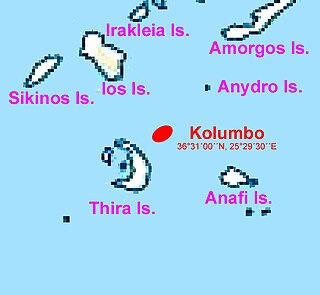
WKolumbo is an active submarine volcano in the Aegean Sea, about 8 km northeast of Cape Kolumbo, Santorini island. The largest of a line of about twenty submarine volcanic cones extending to the northeast from Santorini, it is about 3 km in diameter with a crater 1.5 km across. It was "discovered" when it breached the sea surface in 1649-50, but its explosion was not to be compared to the well-known Thera explosion and caldera collapse, currently dated ca. 1630 BCE, with its devastating consequences for Minoan civilization. The Smithsonian Institution's Global Volcanism Program treats it as part of the Santorini volcano.
 W
WKos or Cos is a Greek island, part of the Dodecanese island chain in the southeastern Aegean Sea. Kos is the third largest island of the Dodecanese by area, after Rhodes and Karpathos; it has a population of 33,388, making it the second most populous of the Dodecanese, after Rhodes. The island measures 40 by 8 kilometres. Administratively, Kos constitutes a municipality within the Kos regional unit, which is part of the South Aegean region. The principal town of the island and seat of the municipality is Kos Town.
 W
WMethana is a town and a former municipality on the Peloponnese peninsula, Greece. Since the 2011 local government reform it is part of the municipality Troizinia-Methana, of which it is a municipal unit. The municipal unit has an area of 50.161 km2.
 W
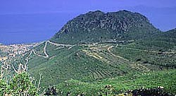
WThe Methana volcano peninsula is situated approximately 50 kilometres (31 mi) southwest of Athens in Greece.
 W
WMilos or Melos is a volcanic Greek island in the Aegean Sea, just north of the Sea of Crete. Milos is the southwesternmost island in the Cyclades group.
 W
WNea Kameni is a small uninhabited Greek island of volcanic origin located in the Aegean Sea, within the flooded Santorini caldera. Nea Kameni and the neighbouring small island Palea Kameni have formed over the past two millennia through repeated eruptions of dacite lava and ash. The Roman historian Cassius Dio records in the year 47 CE "This year a small islet, hitherto unknown, made an appearance close to the island of Thera." Cassius' report may refer to Palaia Kameni. Pliny the Elder reports a new island emerging during on July 8, in the year of the consulship of M. Junius Silanus and L. Balbus, thus 19 CE.
 W
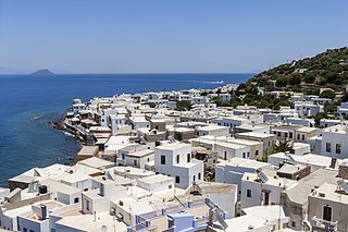
WNisyros also spelled Nisiros is a volcanic Greek island and municipality located in the Aegean Sea. It is part of the Dodecanese group of islands, situated between the islands of Kos and Tilos.
 W
WPalea Kameni, also known as Palia Kameni, is a volcanic island within the Santorini Caldera. The island was formed by a series of volcanic eruptions that formed large deposits of pumice and dacite. The island's name translates to "Old Burnt Island".
 W
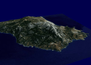
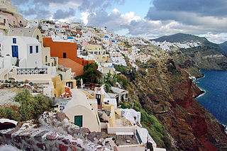
WSantorini, officially Thira and classic Greek Thera, is an island in the southern Aegean Sea, about 200 km (120 mi) southeast from Greece. Its the largest island of a small, circular archipelago, which bears the same name and is the remnant of a volcanic caldera. It forms the southernmost member of the Cyclades group of islands, with an area of approximately 73 km2 (28 sq mi) and a 2011 census population of 15,550. The municipality of Santorini includes the inhabited islands of Santorini and Therasia, as well as the uninhabited islands of Nea Kameni, Palaia Kameni, Aspronisi and Christiana. The total land area is 90.623 km2 (34.990 sq mi). Santorini is part of the Thira regional unit.
 W
WSantorini caldera is a large, mostly submerged caldera, located in the southern Aegean Sea, 120 kilometers north of Crete in Greece. Visible above water is the circular Santorini island group, consisting of Santorini, the main island, Therasia and Aspronisi at the periphery, and the Kameni islands at the center. It has been designated a Decade Volcano.
 W
WSousaki is a dormant volcano and modern solfatara field in northeastern Corinthia, Greece, at the northwest end of the South Aegean Volcanic Arc.
 W
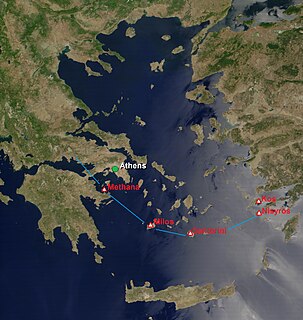
WThe South Aegean Volcanic Arc is a volcanic arc in the South Aegean Sea formed by plate tectonics as a consequence of the subduction of the African plate tectonic plate beneath the Eurasian plate. The southern Aegean is one of the most rapidly deforming regions of the Himalayan-Alpine mountain belt. It is approximately 450 km long and 20 km to 40 km wide and runs from the Isthmus of Corinth on the Greek mainland to the Bodrum peninsula on the Turkish mainland.