 W
WThe Atacama Desert is a desert plateau in South America covering a 1,600 km (990 mi) strip of land on the Pacific coast, west of the Andes Mountains. The Atacama Desert is the driest nonpolar desert in the world, as well as the only true desert to receive less precipitation than the polar deserts and the largest fog desert in the world. Both regions have been used as experimentation sites on Earth for Mars expedition simulations. According to estimates, the Atacama Desert occupies 105,000 km2 (41,000 sq mi), or 128,000 km2 (49,000 sq mi) if the barren lower slopes of the Andes are included. Most of the desert is composed of stony terrain, salt lakes (salares), sand, and felsic lava that flows towards the Andes.
 W
WThe Central Andean dry puna (NT1001) is an ecoregion in the Montane grasslands and shrublands biome, located in the Andean high plateau, in South America. It is a part of the Puna grassland.
 W
WThe Chilean Matorral (NT1201) is a terrestrial ecoregion of central Chile, located on the west coast of South America. It is in the Mediterranean forests, woodlands, and scrub biome, part of the Neotropical realm.
 W
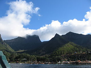
WChiloé Island, also known as Greater Island of Chiloé, is the largest island of the Chiloé Archipelago off the coast of Chile, in the Pacific Ocean. The island is located in southern Chile, in the Los Lagos Region.
 W
WThe Chonos Archipelago is a series of low mountainous elongated islands with deep bays, traces of a submerged Chilean Coast Range. Most of the islands are forested with little or no human settlement. The deep Moraleda Channel separates the islands of the Chonos Archipelago from the mainland of Chile and from Magdalena Island.
 W
WThe Desventuradas Islands is a group of four small islands located 850 kilometres (530 mi) off the coast of Chile, northwest of Santiago in the Pacific Ocean. They are considered part of Insular Chile.
 W
WEaster Island is an island and special territory of Chile in the southeastern Pacific Ocean, at the southeasternmost point of the Polynesian Triangle in Oceania. Easter Island is most famous for its nearly 1,000 extant monumental statues, called moai, created by the early Rapa Nui people. In 1995, UNESCO named Easter Island a World Heritage Site, with much of the island protected within Rapa Nui National Park.
 W
WThe Juan Fernández Islands are a sparsely inhabited island group in the South Pacific Ocean reliant on tourism and fishing. Situated 670 km off the coast of Chile, they are composed of three main volcanic islands: Robinson Crusoe, Alejandro Selkirk and Santa Clara. The group is considered part of Insular Chile.
 W
WLomas, also called fog oases and mist oases, are areas of fog-watered vegetation in the coastal desert of Peru and northern Chile. About 100 lomas near the Pacific Ocean are identified between 5°S and 30°S latitude, a north-south distance of about 2,800 kilometres (1,700 mi). Lomas range in size from a small vegetated area to more than 40,000 hectares and their flora includes many endemic species. Apart from river valleys and the lomas the coastal desert is almost without vegetation. Scholars have described individual lomas as "an island of vegetation in a virtual ocean of desert."
 W
WThe Magellanic moorland or Magellanic tundra is an ecoregion on the Patagonian archipelagos south of latitude 48° S. It is characterized by high rainfall with a vegetation of scrubs, bogs and patches of forest in more protected areas. Cushion plants, grass-like plants and bryophytes are common.
 W
WThe Magellanic subpolar forests are a terrestrial ecoregion of southernmost South America, covering parts of southern Chile and Argentina, and are part of the Neotropical realm. It is a temperate broadleaf and mixed forests ecoregion, and contains the world's southernmost forests.
 W
WMaulino forest is a forest type naturally growing in the Chilean Coast Range of Central Chile from latitude 35°55 to 36°20 S. The chief tree species is Nothofagus glauca. Other tree species include Nothofagus leonii, Nothofagus alessandri and Gomorterga keule. The forest grows at a transition zone between Mediterranean climate to humid temperate climate. Precipitations vary from 1000 to 700 mm/a and are concentrated in winter. According to geographers Humberto Fuenzalida and Edmundo Pisano the forest is one of mesophytes on the transition zone of temperate rain forests.
 W
WThe Patagonian Desert, also known as the Patagonian Steppe is the largest desert in Argentina and is the 8th largest desert in the world by area, occupying 673,000 square kilometers (260,000 mi2). It is located primarily in Argentina and is bounded by the Andes, to its west, and the Atlantic Ocean to its east, in the region of Patagonia, southern Argentina. To the north the desert grades into the Cuyo Region and the Monte. The central parts of the steppe are dominated by shrubby and herbaceous plant species albeit to the west, where precipitation is higher, bushes are replaced by grasses. Topographically the deserts consist of alternating tablelands and massifs dissected by river valleys and canyons. The more western parts of the steppe host lakes of glacial origin and grades into barren mountains or cold temperate forests along valleys.
 W
WThe Patagonian grasslands (NT0804) is an ecoregion in the south of Chile, Argentina and the Falkland Islands. The grasslands are home to diverse fauna, including several rare or endemic species of birds. There are few protected areas. The grasslands are threatened by overgrazing by sheep, which supply high-quality merino wool. Efforts are being made to develop sustainable grazing practices to avoid desertification.
 W
WThe puna grassland ecoregion, of the montane grasslands and shrublands biome, is found in the central Andes Mountains of South America. It is considered one of the eight Natural Regions in Peru, but extends south, across Bolivia, as far as northern Argentina and Chile. The term puna encompasses diverse ecosystems of the high Central Andes above 3200–3400 m.
WEaster Island is an island and special territory of Chile in the southeastern Pacific Ocean, at the southeasternmost point of the Polynesian Triangle in Oceania. Easter Island is most famous for its nearly 1,000 extant monumental statues, called moai, created by the early Rapa Nui people. In 1995, UNESCO named Easter Island a World Heritage Site, with much of the island protected within Rapa Nui National Park.
 W
WThe Southern Andean steppe is a montane grasslands and shrublands ecoregion occurring along the border of Chile and Argentina in the high elevations of the southern Andes mountain range.
 W
WThe Valdivian temperate forests (NT0404) is an ecoregion on the west coast of southern South America, in Chile and extending into Argentina. It is part of the Neotropical realm. The forests are named after the city of Valdivia. The Valdivian temperate rainforests are characterized by their dense understories of bamboos, ferns, and for being mostly dominated by evergreen angiosperm trees with some deciduous specimens, though conifer trees are also common.