 W
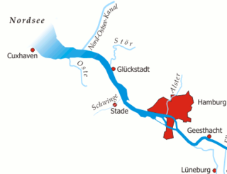
WThe Niederelbe is a 108 kilometers long section of the river Elbe, from western Hamburg downstream to its mouth into the North Sea near Cuxhaven. Starting at Mühlenberger Loch near Finkenwerder, Hamburg, it gradually widens from 2 km (1.2 mi) to 18 km (11 mi). Once passing the Hamburg state border, the Niederelbe also forms the border between the states of Lower Saxony and Schleswig-Holstein.
 W
WThe Unterelbe or, in English usually the Lower Elbe, refers to the lower reaches of the river Elbe in Germany influenced by the tides.
 W
WThe Elbe is one of the major rivers of Central Europe. It rises in the Krkonoše Mountains of the northern Czech Republic before traversing much of Bohemia, then Germany and flowing into the North Sea at Cuxhaven, 110 km (68 mi) northwest of Hamburg. Its total length is 1,094 kilometres (680 mi).
 W
WDradenau was a branch of the river Elbe near Hamburg, Germany. The name was also used for two islands created by the channel, Gros Dradenau and Klein Dradenau.
 W
WKöhlbrand is an anabranch of the Unterelbe river in the Port of Hamburg, Germany. It has a width of approximately 325 metres (1,066 ft).
 W
WThe Norderelbe is one of the two big anabranches of the Unterelbe river in the area which is now the Port of Hamburg, Germany. The other anabranch is the Süderelbe. Together they form the island of Wilhelmsburg.
 W
WThe Rethe is a waterway in the Port of Hamburg, Germany.
 W
WThe Süderelbe is the biggest anabranch of the Unterelbe river in the area which is now the Port of Hamburg, Germany. Its natural flow path was redirected through the Köhlbrand.
 W
WVerlorenes Wasser is the name given to several streams on the right-hand perimeter of the Dresden Basin in Saxony, Germany, in some cases as their proper name, in others as a colloquial name.
 W
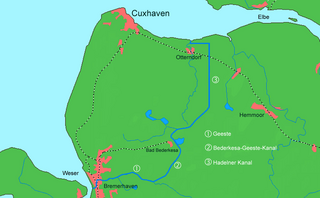
WThe Elbe–Weser waterway or Elbe–Weser shipping channel is a short-cut between the rivers Elbe and Weser in North Germany which is part-canal and part-river. It has a length of 54.7 kilometres (34.0 mi) and is designed for smaller coastal vessels. It includes some 60 kilometres (37 mi) of canal dykes and 45 kilometres (28 mi) of canal paths. The channel starts in Otterndorf with the Hadeln Canal, then becomes the Bederkesa-Geeste Canal from the town of Bad Bederkesa to the River Geeste, the final leg of the shipping channel, which flows into the Weser at Bremerhaven. It is owned by the state of Lower Saxony, maintained by the NLWKN from its Stade office. Today they just look after maintenance of the drainage system, because the economic element of the canal – commercial shipping which was particularly thriving in the late 1960s – declined increasingly from 1973 onwards and today hardly exists at all. Nevertheless the waterway is still used by smaller yachts as a short cut between Elbe and Weser.
 W
WThe Elbe–Havel Canal is a 56-kilometre-long waterway in Germany. It links Magdeburg, on the River Elbe, with Brandenburg on the River Havel.
 W
WThe Elbe Lateral Canal, is a 115-kilometre (71 mi) long canal in Lower Saxony, Germany. It runs from the Mittelland Canal near Gifhorn to the Elbe in Artlenburg. It forms an important transport connection between southern and northern Germany, and it provides a bypass of a section of the Elbe with limited navigability. At the construction start it was also thought as a bypass outside the GDR, considered politically unreliable.
 W
WThe Mittelland Canal, also known as the Midland Canal, is a major canal in central Germany. It forms an important link in the waterway network of that country, providing the principal east-west inland waterway connection. Its significance goes beyond Germany as it links France, Switzerland and the Benelux countries with Poland, the Czech Republic and the Baltic Sea.
 W
WThe Elbe Sluice is a lock on the Elbe river in Ústí nad Labem, Czech republic, located immediately below the Střekov Castle. The waterworks were built between 1923 and 1935 according to plans of architect František Vahala. Their main purpose was to navigate the Elbe in the area of the Střekov rapids, which were often impassable. In its time it was one of the largest waterworks in the country and one with the most modern technical concept in Europe. The hydroelectric power plant, which is part of the sluice, was put into operation in 1935. the waterworks is build in the functionalism style.
 W
WThe Amselsee is a small reservoir in the spa town of Rathen in Saxon Switzerland. It is located in the Free State of Saxony in Eastern Germany.
 W
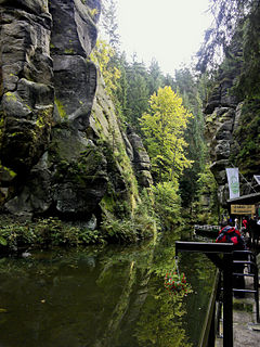
WThe Obere Schleuse in Hinterhermsdorf is a barrage system on the German-Czech border river of Kirnitzsch and impounds the water over a length of 700 metres. It was originally a facility for timber rafting. There are boat rides on the reservoir today during the summer months. At the boat landing point the water depth is 1 metre; by the dam it is 4 metres. The water temperature rarely climbs above 8 °C in summer. In the winter months, during when there are no boat trips, the water is not impounded and the Kirnitzsch flows in its original river bed.
 W
WThe Nausdorf Canal is a canal in the municipalities of Lenzen and Karstädt in the northwest of Brandenburg, Germany. It links two lakes — the Rambower See, in Karstädt, and the Rudower See, in Lenzen — and runs through the Rambower Moor. It takes its name from the village of Nausdorf, part of Lenzen, located midway along the canal.
 W
WThe Gottleuba Dam is the second highest dam in Saxony, Germany. It serves as a reservoir for water supply for the town Pirna and provides flood protection, but energy production is small. The dam was built between 1965 and 1974. It is located at the northern foot of the Erzgebirge, southwest of Bad Gottleuba. It dams up the Gottleuba river.