 W
WThe Fraser River is the longest river within British Columbia, Canada, rising at Fraser Pass near Blackrock Mountain in the Rocky Mountains and flowing for 1,375 kilometres (854 mi), into the Strait of Georgia at the city of Vancouver. It is the 11th longest river in Canada. The river's annual discharge at its mouth is 112 cubic kilometres (27 cu mi) or 3,550 cubic metres per second (125,000 cu ft/s), and it discharges 20 million tons of sediment into the ocean.
 W
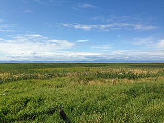
WThe Alaksen National Wildlife Area is located on Westham Island in the city of Delta, British Columbia. It is an important stopover point for many species of birds migrating along the Pacific Flyway.
 W
WThe Bedford Channel is a small side channel of the Fraser River near the north end of the Township of Langley, on the south side of McMillan Island. The pair of islands—Brae Island and McMillan Island that protect the riverfront of Fort Langley, British Columbia are reached by the bridge that crosses the Bedford Channel on the way to the now-closed Albion Ferry terminal and the main reserve community of the Kwantlen First Nation on McMillan Island. The Bedford name has been used in the name of a new housing development in the town of Fort Langley.
 W
WCastle Rock is an unincorporated community on the west bank of the Fraser River between the cities of Williams Lake and Quesnel, British Columbia, Canada, located in that province's Cariboo Country opposite the community of Margeruite and near Alexandria. Castle Rock is named for a rock outcrop of the same name on the Fraser River in that area.
 W
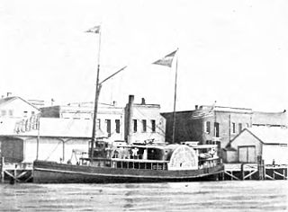
WThe PS Eliza Anderson operated from 1858 to 1898 mainly on Puget Sound, the Strait of Georgia, and the Fraser River but also for short periods in Alaska. She was generally known as the Old Anderson and was considered slow and underpowered even for the time. Even so, it was said of her that "no steamboat ever went slower and made money faster." She played a role in the Underground Railroad and had a desperate last voyage to Alaska as part of the Klondike Gold Rush.
WF.H. Barber Provincial Park is a provincial park in British Columbia, Canada. Comprising 8.5 ha of Fraser River floodplain in its natural state, it is one of only two secured public access points to the Fraser between Chilliwack and Hope. It is located at the confluence of Wahleach Creek and the Fraser one mile west of Laidlaw, British Columbia and is bounded on the south by the tracks of the Canadian National Railway.
 W
WThe Fraser Canyon is a major landform of the Fraser River where it descends rapidly through narrow rock gorges in the Coast Mountains en route from the Interior Plateau of British Columbia to the Fraser Valley. Colloquially, the term "Fraser Canyon" is often used to include the Thompson Canyon from Lytton to Ashcroft, since they form the same highway route which most people are familiar with, although it is actually reckoned to begin above Williams Lake, British Columbia at Soda Creek Canyon near the town of the same name.
 W
WThe Fraser Plateau is an intermontane plateau. It is one of the main subdivisions of the Interior Plateau located in the Central Interior of British Columbia.
WThe Fraser Plateau and Basin Complex is an ecoregion, as defined by the World Wildlife Fund. It encompasses the middle reaches of the watershed of the Fraser River as it traverses the northern part of the Interior Plateau of British Columbia. The WWF ecoregion is similar in description to two of the ecoregions within Environment Canada's Montane Cordillera Ecozone: The Fraser Basin and the Fraser Plateau. Much of the Fraser Plateau is underlain by volcanic rocks which have steep escarpments along rivers and creeks and almost flat upper surfaces.
 W
WThe Fraser Valley is the region of the Fraser River basin in southwestern British Columbia downstream of the Fraser Canyon. The term is sometimes used outside British Columbia to refer to the entire basin including the Fraser Canyon and up from there to its source, but in general British Columbian usage of the term refers to the stretch of the river downstream from the town of Hope, and includes all of the Canadian portion of the Fraser Lowland and areas flanking it.
 W
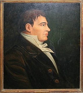
WSimon Fraser was a fur trader and explorer of Scottish ancestry who charted much of what is now the Canadian province of British Columbia. He also built the first European settlement in British Columbia.
 W
WThe Grand Canyon of the Fraser is a short gorge on the Fraser River in central British Columbia about 30km upstream from the confluence of the Bowron River and about 100km due east of downtown Prince George, British Columbia. Just downstream of the canyon, which pierces a rocky ridge, is a stretch of water called Scow Rapids, where towropes from the gorge's banks dragged vessels and rafts upstream. The canyon is located in the section of the Sugarbowl-Grizzly Den Provincial Park and Protected Area that is about 6km south-southwest of Hutton.
 W
WMoran Dam, also called High Moran Dam or Moran Canyon Dam, was a 1950s proposal to dam the Fraser River in the Canadian province of British Columbia (BC). The structure was planned in the wake of devastating floods in a time of rapidly growing power demand, and if built, would have powered the largest hydroelectric facility in North America. After a protracted environmental battle, Moran Dam was defeated in 1972, mainly over concerns of its adverse impact on salmon populations in the Fraser River basin. The shelving of the project also influenced cancellation of other hydro developments along the river, and today the Fraser remains one of the most productive salmon fisheries on the continent.
 W
WOverlander Falls is a waterfall on the Fraser River in Mount Robson Provincial Park, British Columbia, Canada. It is popular for kayakers. The falls are reached by a short walking trail which starts on the Yellowhead Highway 2 km (1.2 mi) east of the Mount Robson visitor centre. The waterfall is named for the Overlanders expedition of 1862. A group of 175 men and 1 woman from Ontario travelled across the prairies and through the Rocky Mountains, intending to reach the Barkerville or Cariboo goldfields. Just west of Overlander Falls, the group split. About half continued down the Fraser River, eventually reaching Barkerville in late fall of 1862, but over a year had elapsed since Billy Barker's gold strike and there were no claims left to stake. The other half abandoned their dreams of gold and rafted down the North Thompson River to Fort Kamloops.
 W
WPrincess Louise was a sidewheel steamboat built in 1869. From 1869 to 1879 this ship was named Olympia. In 1879 the name was changed to Princess Louise, after Princess Louise, Duchess of Argyll, a daughter of Queen Victoria who was married to Marquess of Lorne (1845-1914), Governor General of Canada from 1878 to 1883. Princess Louise was the last sidewheeler to be operated commercially on the coast of British Columbia.
 W
WRearguard Falls Provincial Park is a provincial park in British Columbia, Canada, protecting Rearguard Falls on the Fraser River. It is located just above its emergence into the Rocky Mountain Trench near the community of Tete Jaune Cache. The park is easily accessed via BC Highway 16. Rearguard Falls is one of only two waterfalls on the 1,375 km (854 mi)-long Fraser River; the other is a few kilometres upstream at Overlander Falls.
 W
WThis article is about Steamboats of the Lower Fraser River and Harrison Lake. The first steamboat on the Fraser River was the SS Beaver which entered Pacific waters in 1835. It was an itinerant supply for the Hudson's Bay Company roving throughout the lower Columbia River in Oregon and around coastal Washington, British Columbia and southeastern Russian America (Alaska), long before those political entities came into being.
 W
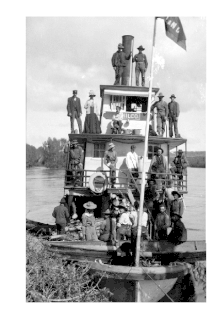
WTwelve paddlewheel steamboats plied the upper Fraser River in British Columbia from 1863 until 1921. They were used for a variety of purposes: working on railroad construction, delivering mail, promoting real estate in infant townsites and bringing settlers in to a new frontier. They served the towns of Quesnel, Barkerville and Fort George. Some only worked the Fraser from Soda Creek to Quesnel, while others went all the way to Tête Jaune Cache or took the Nechako River and served Fort Fraser and beyond.