 W
WLake St. Clair is a freshwater lake that lies between the Canadian province of Ontario and the U.S. state of Michigan. It was named in 1679 by French Catholic explorers after Saint Clare of Assisi, on whose feast day they first sighted this body of water.
WAnchor Bay is a freshwater bay that lies to the North and is a part of Lake St. Clair and is located in the U.S. state of Michigan. Anchor Bay is best described as the Northern region of Lake St. Clair. It generally encompasses the waters north of a line between Huron Point and the Middle Channel of the St. Clair River. It has a total surface area of over 90 square miles (230 km2) and the depth ranges from 1 to 11 feet. Overall the bay is quite shallow for its immense size.
 W
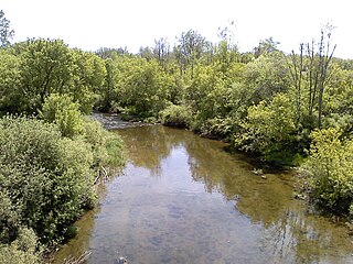
WThe Clinton River is a river in southeastern Michigan in the United States. It is named in honor of DeWitt Clinton, who was governor of New York from 1817 to 1823.
 W
WThe Clinton–Kalamazoo Canal is a canal in Michigan that was abandoned after being only partially completed. The canal was to connect Lake St. Clair with Lake Michigan. Project backers were inspired by the success of the Erie Canal in New York, which was completed in 1825. After gaining statehood in 1837, Michigan elected its first governor, Stevens Thomson Mason, who initiated an ambitious program of internal improvements, including three railroads and two canals. On March 21, 1837, the Legislature authorized Governor Mason to contract a loan for the construction of the canal from Mt. Clemens to Rochester, a railroad from Shelby to Detroit, a railroad from Detroit across the State and a railroad from Port Huron into the interior, to be known as the Port Huron & Grand River road. In the spring of 1838, a Board of Commissioners composed of seven men, was appointed to take charge of the canal work.
 W
WThe Detroit River flows west and south for 24 nautical miles from Lake St. Clair to Lake Erie as a strait in the Great Lakes system. The river divides the metropolitan areas of Detroit, Michigan, and Windsor, Ontario — an area collectively referred to as Detroit–Windsor — and forms part of the border between Canada and the United States. The Ambassador Bridge, the Detroit–Windsor Tunnel, and the Michigan Central Railway Tunnel connect the cities.
 W
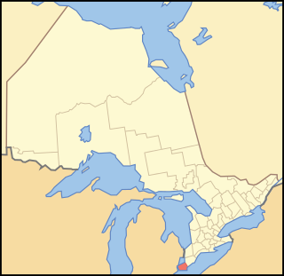
WEssex County is a primarily rural county in Southwestern Ontario, Canada comprising seven municipalities: Amherstburg, Kingsville, Lakeshore, LaSalle, Leamington, Tecumseh and the administrative seat, Essex. Essex County has a population of 181,530 as of the Canada 2016 Census.
 W
WGrosse Pointe Farms is a suburban city bordering Detroit, located in Wayne County in the U.S. state of Michigan. The population was 9,479 at the 2010 census. It is bordered by Canada and Lake Saint Clair on the south and east, Grosse Pointe on the west, Detroit on the north, and Grosse Pointe Woods and Grosse Pointe Shores on the northeast. Lakeshore Drive begins in Grosse Pointe Farms, where, just east of Fisher Road, the eastbound driver or pedestrian on Jefferson Avenue descends to lake level, following the curvature of the lakefront to the northeast.
 W
WGrosse Pointe Shores is a city in the U.S. state of Michigan. The city, which is entirely residential, is the location of the Grosse Pointe Yacht Club on Lake Saint Clair. The city's population was 3,008 at the 2010 census. It has the 50th highest income for a municipality with over 1,000 citizens in the country and the first highest income in the state of Michigan.
 W
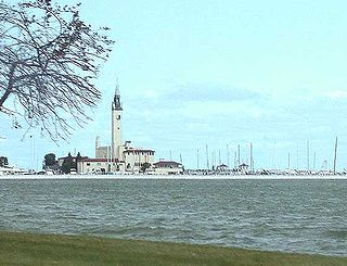
WThe Grosse Pointe Yacht Club (GPYC) is a private yacht club located on the shore of Lake St. Clair in Grosse Pointe Shores, Michigan. It was founded in 1914 through the efforts of a group of 25 sailing and ice-boating enthusiasts. The club is a member of the Detroit Regional Yacht-racing Association (DRYA). The clubhouse is prominently visible and a well-known landmark along the shoreline of the lake north of Detroit.
 W
WHarsens Island is a wet marshy location at the mouth of the St. Clair River on Lake St. Clair, in the U.S. state of Michigan. Politically, the island is in Clay Township of St. Clair County
WLake St. Clair Metropark/Metro Beach Metropark is a 770-acre unit of the Huron-Clinton Metroparks system located roughly 20 miles (32 km) northeast of downtown Detroit, Michigan in Harrison Township, Macomb County. Lake St. Clair Metropark has been in existence since 1950 and has seen many changes since then. Originally named St. Clair Metropolitan Beach, it was renamed in 1953 to Metropolitan Beach Metropark and later shortened to Metro Beach Metropark. On December 8, 2011, the Board of Commissioners for the Huron-Clinton Metroparks approved changing the name to Lake St. Clair Metropark. The park is located at Jefferson Avenue and Metropolitan Parkway and there are signs to Lake St. Clair Metropark on Interstate 94 (I-94).
 W
WSt. Clair Beach is a community on Lake Saint Clair in the town of Tecumseh, Ontario, Canada. Until 1998, the village was a separate entity, but was amalgamated into Tecumseh.
 W
WSt. Clair Flats Front and Rear Range Light are two lighthouse structures situated off the southeastern tip of Harsens Island at Lake St. Clair.
 W
WSt. Clair Shores is a suburban city bordering Lake St. Clair in Macomb County of the U.S. state of Michigan. It forms a part of the Metro Detroit area, and is located approximately 13 miles (21 km) northeast of downtown Detroit. The population was 59,715 at the 2010 census.
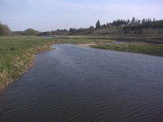
WThe St. Clair River is a 40.5-mile-long (65.2 km) river in central North America which flows from Lake Huron into Lake St. Clair, forming part of the international boundary between the Canadian province of Ontario and the U.S. state of Michigan. The river is a significant component in the Great Lakes Waterway, whose shipping channels permit cargo vessels to travel between the upper and lower Great Lakes.
 W
WTecumseh is a town in Essex County in Southwestern Ontario, Canada. It is on Lake St. Clair east of Windsor and had a population of 23,229 at the 2016 census. It is part of the Windsor census metropolitan area, and is a part of the Windsor-Essex County region along with Amherstburg, Kingsville, Lakeshore, LaSalle and Leamington.
 W
WThe Thames River is located in southwestern Ontario, Canada.
 W
WWalpole Island is an island and First Nation reserve in southwestern Ontario, Canada, on the border between Ontario and Michigan in the United States. It is located in the mouth of the St. Clair River on Lake St. Clair, about 121 kilometres (75 mi) by road from Windsor, Ontario and 124 kilometres (77 mi) from Detroit, Michigan.