 W
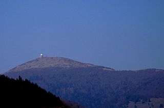
WThe Ballon d'Alsace German: Elsässer Belchen, sometimes also called the Alsatian Belchen to distinguish it from other mountains named "Belchen", is a mountain at the border of Alsace, Lorraine, and Franche-Comté. From its top, views include the Vosges, the Rhine valley, the Black Forest, and the Alps.
 W
WClimont, formerly called "Clivemont" in Old French, and "Winberg" in Old Alsatian, is a conical sandstone peak of the Vosges mountains. The mountain, with a cut-off shape, is known from afar by walkers and modern-day travellers.
 W
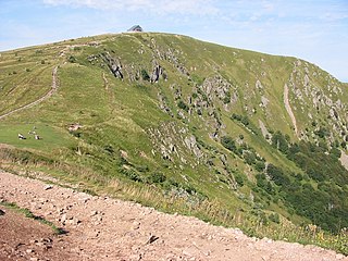
WMont Donon is the highest peak in the northern Vosges. It is a Category 2 climb in the Tour de France.
 W
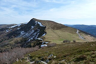
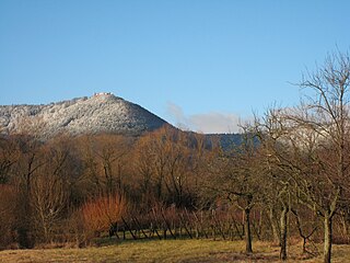
WThe Grand Ballon or Great Belchen is the highest mountain of the Vosges, located 25 kilometres (16 mi) northwest of Mulhouse, France. It is also the highest point of the Grand-Est French region.
 W
WHartmannswillerkopf, also known as the Vieil Armand (French) or Hartmannsweiler Kopf is a pyramidal rocky spur in the Vosges mountains of the Grand Est region, France. The peak stands at 956 metres (3,136 ft) overlooking the Rhine valley. At Hartmannswillerkopf stands a national monument of World War I for the fighting which took place in the trenches here.
 W
WThe Hohneck is, at 1,363 m (4,472 ft) the third highest summit of the Vosges Mountains and the highest point of Lorraine. On its summit stands a mountain hut, clearly visible in the distance. Nearby the mountain's top is located the ski resort of La Bresse Hohneck.
 W
WThe Kastelberg is the fourth highest summit of the Vosges Mountains. It is located on the former border between the French regions of Alsace and Lorraine.
 W
WThe Klintzkopf, located in the French region of Alsace, is the fifth-highest summit of the Vosges Mountains.
 W
WThe Petit Ballon or Little Belchen, is one of the highest peaks of the Vosges Mountains in the department of Haut-Rhin, Alsace in France. Its height is 1272m, above the sea level and it is located about 5 km away from the village of Wasserbourg. The Rothenbrunnen mountain hut is located 500m below. A car park is a further 500m away.
 W
WThe Pierre de Laitre, or Pierre de l'Aître is a stone at 624 metres (2,047 ft) above sea level that forms the summit of a wooded sandstone mountain of the same name in the Kemberg massif to the north of the town of Taintrux, in the canton of Saint-Dié, department of Vosges. The mountain overlooks the old cemetery, or l'aître of Taintrux, from which the stone and the mountain take their name.
 W
WThe Rainkopf is one of the highest summits of the Vosges Mountains. It is located on the border between the French regions of Alsace and Lorraine. Not faraway from its summit is located a mountain hut called Refuge "Louis Hergès" au Rainkopf
 W
WThe Rothenbachkopf is a mountain, 1,315 metres high, in the High Vosges in France. Only a few metres to the west of the summit runs the Route des Crêtes heading south from the Col de la Schlucht. Several Vosges Club hiking trails run over the top. A few kilometres north of the Rothenbachkopfs the border between Alsace and Lorraine turns and heads southwest.
 W
WMont Sainte-Odile is a 764-metre-high peak in the Vosges Mountains in Alsace in France, immediately west of Barr. The mountain is named after Saint Odile. It has a monastery/convent at its top called the Hohenburg Abbey, and is notable also for its stone fortifications called "the Pagan Wall." In 1992, Air Inter flight 148 crashed near this area.
 W
WThe Storkenkopf is the second-highest summit of the Vosges Mountains. It is located in the French region of Alsace, close to the Grand Ballon.
 W
WThe Taennchel is one of the summits of the Vosges Mountains, rising to 988 metres (3,241 ft). The Taennchel rises at the East of France, in the département of Haut-Rhin, halfway between Strasbourg to the North and Mulhouse to the South, around 60 km (40 mi) from both cities.
 W
WLe Tanet (Tanneck) is one of the highest peaks of the Vosges Mountains in the department of Haut-Rhin, Alsace in France. Its height is 1292m, above the sea level and it is located about 5 km away from the Hohneck and north of the Col de la Schlucht. Near the Tanet the Route des Cretes crosses the Col de la Schlucht and the Lac Blanc. About the ridge runs the GR 5 across the border between Alsace and Lorraine. From the east the Tanet is accessible via a ski slope from the Auberge du Tanet - Seestaedtlé.
WThe Wasenkoepfel (526 m) is a hill northwest of Oberbronn in the Lower Alsace in the French Vosges. It is the highest point of the southern Wasgau, a Franco-German, cross-border region that comprises the southern part of the Palatinate Forest and the northern part of the Vosges.
 W
WAt 581 m, the Grand Wintersberg is the highest hill in the North Vosges in Alsace, France.