 W
WAmong the longest rivers of Mexico are 26 streams of at least 250 km (160 mi). In the case of rivers such as the Colorado, the length listed in the table below is solely that of the main stem. In the case of the Grijalva and Usumacinta, it is the combined lengths of two river systems that share a delta. In the case of the Nazas and Aguanaval, it is the combined lengths of separate rivers that flow into the same closed basin.
 W
WThe Acatlán River is a river of Mexico.
 W
WThe Alamo River flows west and north from the Mexicali Valley across the Imperial Valley (California). The 52-mile-long (84 km) river drains into the Salton Sea.
 W
WThe Calvillo River is a river of Mexico.
 W
WThe Candelaria River is a river of Central America that flows from Guatemala to Laguna de Términos, Mexico, It has a length of about 400 kilometres (250 mi) and drains a basin of 9,228 km2 (3,563 sq mi).
 W
WThe Cazones River is a river of Mexico.
 W
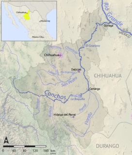
WThe Río Conchos is a large river in the Mexican state of Chihuahua. It joins the Río Bravo del Norte at the town of Ojinaga, Chihuahua.
 W
WThe Culiacán River is a river that is formed at the confluence of the Tamazula River and Humaya River, located in Culiacán city of Sinaloa state, in northwestern Mexico.
WThe Fuerte River is a river in the state of Sinaloa, in northwestern Mexico. It flows from headwaters in the Sierra Madre Occidental to the Pacific Ocean in the Gulf of California.
 W
WThe Río Necaxa, or Necaxa River, is one of the main rivers of the Mexican state of Puebla. Beginning south of Huauchinango with the name Totolapa, it runs through tall mountains and deep canyons forming the waterfalls known as Salto Chico y Salto Grande; its flow is also used for generation of hydroelectric power.
 W
WThe New River flows north from near Cerro Prieto, through the city of Mexicali, Baja California, Mexico, into the United States through the city of Calexico, California, towards the Salton Sea. The river channel has existed since pre-historic times. However, the river as known today formed from a levee failure and massive flooding that re-created the Salton Sea.
 W
WThe Rio Grande is one of the principal rivers in the southwest United States and northern Mexico. The Rio Grande begins in south-central Colorado in the United States and flows to the Gulf of Mexico. After passing through the length of New Mexico along the way, it forms part of the Mexico–United States border. According to the International Boundary and Water Commission, its total length was 1,896 miles (3,051 km) in the late 1980s, though course shifts occasionally result in length changes. Depending on how it is measured, the Rio Grande is either the fourth- or fifth-longest river system in North America.
 W
WThe Sabinas River is a river of Mexico. It is a tributary of the Rio Salado, which in turn flows into the Rio Grande.
 W
WThe Sahuaripa River is a river of Mexico.
 W
WThe Suchiapa River is a river in the state of Chiapas, Mexico.
 W
WViaducto Miguel Alemán is a crosstown freeway, opened in September 1950, that runs east-west across central Mexico City. In the center of the road is a river encased in cement to control flooding. Metro Viaducto is named after this road.
 W
WThe Yaqui River is a river in the state of Sonora in northwestern Mexico. It was formerly known as the Rio del Norte. Being the largest river system in the state of Sonora, the Yaqui river is used for irrigation, especially in the Valle del Yaqui.
 W
WThe Yautepec River is a river of Mexico.