 W
WA volcanic crater is an approximately circular depression in the ground caused by volcanic activity. It is typically a bowl-shaped feature within which occurs a vent or vents. During volcanic eruptions, molten magma and volcanic gases rise from an underground magma chamber, through a tube-shaped conduit, until they reach the crater's vent, from where the gases escape into the atmosphere and the magma is erupted as lava. A volcanic crater can be of large dimensions, and sometimes of great depth. During certain types of explosive eruptions, a volcano's magma chamber may empty enough for an area above it to subside, forming a type of larger depression known as a caldera.
 W
WThe Bridge River Vent is a volcanic crater in the Pacific Ranges of the Coast Mountains in southwestern British Columbia, Canada. It is located 51 km (32 mi) west of Bralorne on the northeastern flank of the Mount Meager massif. With an elevation of 1,524 m (5,000 ft), it lies on the steep northern face of Plinth Peak, a 2,677 m (8,783 ft) high volcanic peak comprising the northern portion of Meager. The vent rises above the western shoulder of the Pemberton Valley and represents the northernmost volcanic feature of the Mount Meager massif.
 W
WCrater Rings are adjacent, symmetrical volcanic pit craters in the Western Snake River Plain about 8 miles northwest of Mountain Home, Idaho. They are one of few examples of volcanic craters in the continental United States. The craters are at the summit of a broad shield volcano. The eastern crater is about 3000 ft across and 350 ft deep. The western is 2500 ft across and 300 ft deep. The craters are probably former lava lakes similar to Halemaʻumaʻu of the Kīlauea volcano of Hawaii. The volcano is the youngest of the shield volcanoes near Mountain Home and is estimated to be less than 2 million years old.
 W
WFoulden Maar, a fossil site near Middlemarch in Otago, New Zealand, formed in a volcanic eruption 23 million years ago. The resulting crater lake filled with diatomite, composed of layers of silica-shelled algae (diatoms) and exceptional fossils of plants, fishes, spiders and insects from the surrounding sub-tropical Miocene forest. As the only known maar of its kind in the Southern Hemisphere, it is one of New Zealand's pre-eminent fossil sites. A 2018 proposal to mine Foulden Maar for livestock-food additive has attracted significant public opposition.
 W
WFormica Leo, named for its similar shape to the pitfall built by the antlion, is a small volcanic crater of the Piton de la Fournaise, the active volcano on the eastern side of Réunion island in the Indian Ocean. It is located at the bottom of the caldera called Enclos Fouqué, just beneath the mountain pass Pas de Bellecombe.
 W
WMount Fraser is a volcanic cone near Beveridge, Victoria, Australia. It is the largest scoria cone near Melbourne. The extinct volcano last erupted about one million years ago. It is about 120 metres in height above the surrounding land. The distance around the base of the volcano is 1200 metres. There are two craters. One crater is wide and shallow, and the other is small and closed. It is listed on the Australian Heritage database.
 W
WHalemaʻumaʻu is a pit crater within the much larger Kīlauea Caldera in Hawaii Volcanoes National Park. The roughly circular crater was 770 meters (2,530 ft) x 900 m (2,950 ft) before collapses that roughly doubled the size of the crater after May 3, 2018. Following the collapses of 2018, the bottom of Halemaʻumaʻu lies roughly 600 m (2,000 ft) below the caldera floor. Halemaʻumaʻu is home to Pele, goddess of fire and volcanoes, according to the traditions of Hawaiian religion. Halemaʻumaʻu means "house of the ʻāmaʻu fern".
 W
WHawkes Heights is an ice-filled volcanic crater rising to 2,000 metres (6,600 ft) that dominates the southern part of Coulman Island, in the Ross Sea, Antarctica, and marks the island's summit. The feature was named by the New Zealand Geological Survey Antarctic Expedition (NZGSAE), 1958–59, for Captain William M. Hawkes, U.S. Navy, who took a leading part in early air operations from Williams Field near McMurdo Station, including long range photo reconnaissance and supply flights, and the first air landing at the South Pole. He was commander of one of the two planes which made the historic first flight from Christchurch to McMurdo Station on December 17, 1955. His air photos proved of great value to two NZGSAE parties to this part of Victoria Land. Mount Hawkes is also named for Hawkes, who was assigned to Air Development Squadron Six (VX-6) in 1955–56.
 W
WIn Teria volcanic field is a volcanic field in Algeria. It consists of about 20 craters.
 W
WKamojang, popularly known as Kawah Kamojang or, is a geothermal field and tourist spot in West Java, Indonesia. The crater is located in sub-district (kecamatan) Ibun in the Bandung Regency, approximately 45 km to the southeast of Bandung through the towns of Majalaya and Ibun. The crater can also be reached from the opposite direction through the town of Garut, in Garut Regency.
 W
WKaraha Crater or Kawah Karaha is a fumarole field in Java, Indonesia. It is an eroded crater from the last eruption in which its date is unknown. The field covers 250 × 80 m area and contains sulfur deposit.
 W
WKauhakō Crater is a volcanic crater located in Kalawao County, Hawaii, United States. The crater was formed between 230,000 and 300,000 years ago, as the result of the eruption of volcano Pu'u' 'Uao. It is located in the center of the Kalaupapa Peninsula on the island of Molokaʻi, and has a diameter of 500 metres (1,600 ft) by 650 metres (2,130 ft). Lake Kauhakō, located at the bottom of the crater, has the world's greatest depth-to-surface area ratio of a lake and is the fourth deepest lake in the United States. In 2011, the lake underwent an overturning event, causing hydrogen sulfide to float to the surface of the lake and lifeforms, including shrimp and plankton, to disappear.
 W
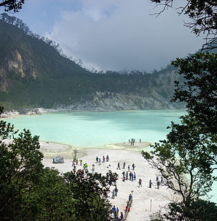
WKawah Putih is a striking crater lake and tourist spot in a volcanic crater about 50 kilometres (31 mi) south of Bandung in West Java in Indonesia.
 W
WNigorigawa Caldera is a volcanic crater in Oshima, Hokkaido, Japan. It has an elevation of 1,168 ft (356m) and it last erupted 12,000 years ago. The caldera has a diameter of 3km.
 W
WPauahi Crater is a volcanic crater measuring 2,000 ft (610 m) long, up to some 1,300 ft (400 m) across, and 300 ft (91 m) deep in Hawaii Volcanoes National Park at 19°22′6″N 155°13′21″W. It is about 3 mi (4.8 km) from the top of the Big Island of Hawaii's Chain of Craters Road, which follows a "chain" that also includes the Hiiaka, Pu'u Huluhulu, Kane Nui O Hamo, Makaopuhi, and Napau craters.
 W
WA pit crater is a depression formed by a sinking or collapse of the surface lying above a void or empty chamber, rather than by the eruption of a volcano or lava vent. Pit craters are found on Mercury, Venus, Earth, Mars, and the Moon. Pit craters are often found in a series of aligned or offset chains and in these cases, the features is called a pit crater chain. Pit crater chains are distinguished from catenae or crater chains by their origin. When adjoining walls between pits in a pit crater chain collapse, they become troughs. In these cases, the craters may merge into a linear alignment and are commonly found along extensional structures such as fractures, fissures and graben. Pit craters usually lack an elevated rim as well as the ejecta deposits and lava flows that are associated with impact craters. Pit craters are characterized by vertical walls that are often full of fissures and vents. They usually have nearly circular openings.
 W
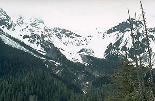
WSherman Crater is an active volcanic crater of Mount Baker in the U.S. state of Washington situated between Sherman Peak and Grant Peak.
 W
WStóra-Eldborg undir Geitahlíð is a small Holocene volcano in Iceland, on Reykjanes peninsula, 50 m high, with a 30 m deep crater. It is located at about 5 km from Krýsuvík and as the name says at the foot of a bigger mountain, the tuya of Geitahlíð.