 W
WBarrier islands are coastal landforms and a type of dune system that are exceptionally flat or lumpy areas of sand that form by wave and tidal action parallel to the mainland coast. They usually occur in chains, consisting of anything from a few islands to more than a dozen. They are subject to change during storms and other action, but absorb energy and protect the coastlines and create areas of protected waters where wetlands may flourish. A barrier chain may extend uninterrupted for over a hundred kilometers, excepting the tidal inlets that separate the islands, the longest and widest being Padre Island of Texas. Sometimes an important inlet may close permanently, transforming an island into a peninsula, thus creating a barrier peninsula. The length and width of barriers and overall morphology of barrier coasts are related to parameters including tidal range, wave energy, sediment supply, sea-level trends, and basement controls. The amount of vegetation on the barrier has a large impact on the height and evolution of the island.
 W
WIn oceanography, geomorphology, and earth sciences, a shoal is a natural submerged ridge, bank, or bar that consists of, or is covered by, sand or other unconsolidated material, and rises from the bed of a body of water to near the surface. Often it refers to those submerged ridges, banks, or bars that rise near enough to the surface of a body of water as to constitute a danger to navigation. Shoals are also known as sandbanks, sandbars, or gravelbars. Two or more shoals that are either separated by shared troughs or interconnected by past or present sedimentary and hydrographic processes are referred to as a shoal complex.
 W
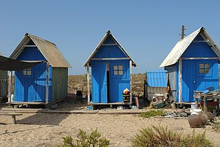
WArmona Island is one of the islands of Algarve, Portugal. Armona is 9 kilometres (6 mi) in length, and from 0.1 to 1 km wide. It is accessible by regular 20-minute Ferry trips or even quicker water taxi from the waterfront in Olhão. The island is populated with a large number of beach houses and 5 cafe bars. The main beach on the Atlantic side of the island is pristine and uncrowded, making it a popular daytrip destination for tourists staying in Olhão itself. The port is a very popular place in the summer when the locals and holiday makers dive/jump off it into the sea.
 W
WBarra El Mezquital is a barrier island on the coast of the Mexican state of Tamaulipas, separating the Laguna Madre from the Gulf of Mexico. It lies approximately 60 kilometres east of San Fernando, Tamaulipas, and 120 km (75 mi) south of Brownsville, Texas, U.S. It is frequently used as a reference point ("breakpoint") in government-issued weather advisories.
 W
WBarreta Island is an island in the Algarve, Portugal, about 7 kilometres (4.3 mi) long and 50 to 600 metres wide.
 W
WThe Boulder Bank is a very unusual naturally formed landform in Nelson, New Zealand. It is a 13 kilometre long stretch of rocky substrate which begins at the Mackay Bluff and ends at the Cut of the Nelson Harbour. Haulashore Island was once a part of the Boulder Bank, but the Cut made it an island, and it is no longer connected to the Boulder Bank. The Boulder Bank separates Tasman Bay and the Nelson Haven and is managed as a scenic reserve by the Department of Conservation. Land access is gained along Boulder Bank Drive, signposted at the northern end of Nelson Haven on State Highway 6.
 W
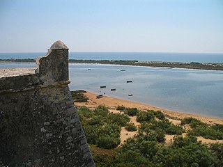
WCacela Island is a sandy barrier island at the mouth of the Ria Formosa in the Algarve region of mainland Portugal. It was part of a peninsula up to the autumn of 2010, when as a result of storm action, the sea cut the peninsula and turned its westernmost part into an island.
 W
WCallawassie Island is one of hundreds of barrier and sea islands in the southeast corner in the outer coastal plain, making up a portion of Beaufort County, South Carolina.
 W
WCijin District is a district of Kaohsiung City, Taiwan, covering Cijin Island (旗津島) and islands in the South China Sea. It is the second smallest district in Kaohsiung City after Yancheng District.
 W
WCulatra Island is a barrier island located in the Ria Formosa in the Algarve region of Portugal. It has an approximate population of around 700 people divided across three communities Farol, Hângares and Culatra.
 W
WThe Frisian Islands, also known as the Wadden Islands or the Wadden Sea Islands, form an archipelago at the eastern edge of the North Sea in northwestern Europe, stretching from the northwest of the Netherlands through Germany to the west of Denmark. The islands shield the mudflat region of the Wadden Sea from the North Sea.
 W
WMatakana Island is located in the western Bay of Plenty in New Zealand's North Island. A long, flat barrier island, it is 20 kilometres (12 mi) in length but rarely more than 3 kilometres (1.9 mi) wide. The island has been continuously populated for centuries by Māori tribes that are mostly associated with Ngāi Te Rangi.
 W
WMoreton Island (Mulgumpin) is an island on the eastern side of Moreton Bay on the coast of South East Queensland, Australia. The Coral Sea lies on the east coast of the island. Moreton Island lies 58 kilometres (36 mi) northeast of the Queensland capital, Brisbane. 95% of the island is contained within a national park and a popular destination for day trippers, four wheel driving, camping, recreational angling and whale watching and a 75-minute ferry ride from Brisbane. It is the third largest sand island in the world. Together with Fraser Island, Moreton Island forms the largest sand structure in the world. It was the traditional country of the Ngugi before the onset of colonization.
 W
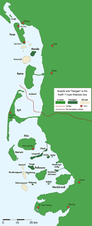
WNorth Frisian Barrier Island is the collective term for three barrier islands due west of the German Halligen in the North Frisian Islands archipelago. The shoals act as natural breakwater for the Halligen and other islands closer to land. Uninhabited, they remain one of the few areas in the Wadden Sea that are unaffected by direct human activity.
 W
WNorth Stradbroke Island, colloquially Straddie or North Straddie, is an island that lies within Moreton Bay in the Australian state of Queensland, 30 kilometres (19 mi) southeast of the centre of Brisbane. Before 1896 the island was part of the Stradbroke Island. In that year a storm separated it from South Stradbroke Island, forming the Jumpinpin Channel. The Quandamooka people are the traditional owners of North Stradbroke island.
 W
WScolt Head Island is an offshore barrier island between Brancaster and Wells-next-the-Sea in north Norfolk. It is in the parish of Burnham Norton and is accessed by a seasonal ferry from the village of Overy Staithe. The shingle and sand island appears to have originated from a former spit extending from the coast, and longshore drift means that it is slowly moving to the west and inshore.
 W
WThe South Stradbroke Island, colloquially South Straddie, is an island that lies within Moreton Bay in the Australian state of Queensland, south of Brisbane and forms the northern end of Gold Coast. The island is a locality within the City of Gold Coast. In the 2016 census, South Stradbroke had a population of 41 people.
 W
WSriharikota is a barrier island off the Bay of Bengal coast located in the Shar Project settlement of Nellore district in Andhra Pradesh. It houses the Satish Dhawan Space Centre, one of the two satellite launch centres in India. Indian Space Research Organisation (ISRO) launches satellites using multistage rockets such as the Polar Satellite Launch Vehicle and the Geosynchronous Satellite Launch Vehicle from Sriharikota.
 W
WTavira Island lies south of the town of Tavira, Portugal, just a few hundred metres off the coast. It is 11 kilometres long and varies between 150 m to 1 km in width. The island has 11 km of the best beaches in the Algarve, including areas where naturism can be legally practised. It is part of the Natural reserve of Ria Formosa. It is also popular among tourists, people that like to swim and bird watchers.