 W
WBadwater Basin is an endorheic basin in Death Valley National Park, Death Valley, Inyo County, California, noted as the lowest point in North America and the United States, with a depth of 282 ft (86 m) below sea level. Mount Whitney, the highest point in the contiguous 48 United States, is only 84.6 miles (136 km) to the northwest.
 W
WBlue Creek Valley is an 18-mile (29 km) long valley located in northeast Box Elder County, Utah. It is endorheic with the Blue Creek Reservoir its lowpoint located south in the valley's center.
 W
WCarson Sink is a playa in the northeastern portion of the Carson Desert in present-day Nevada, United States of America, that was formerly the terminus of the Carson River. Today the sink is fed by drainage canals of the Truckee-Carson Irrigation District. The southeastern fringe of the sink, where the canals enter, is a wetland of the Central Basin and Range ecoregion.
 W
WThe Chuckwalla Valley is a large valley in eastern Riverside County, California, named for a large lizard, the chuckwalla found in the arid Southwestern United States deserts.
 W
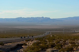
WEldorado Valley, or El Dorado Valley, is a Great Basin valley in the Mojave Desert southeast of Las Vegas and southwest of Boulder City, Nevada. The valley is endorheic, containing the Eldorado Dry Lake. The Great Basin Divide, transects ridgelines and saddles, on the north, northeast, east, and south around the valley, as the valley sits on the east of the McCullough Range, a Great Basin massif, on the Great Basin Divide at its north terminus and its south terminus.
 W
WThe Great Basin is the largest area of contiguous endorheic watersheds in North America. It spans nearly all of Nevada, much of Oregon and Utah, and portions of California, Idaho, Wyoming, and Baja California, Mexico. It is noted for both its arid climate and the basin and range topography that varies from the North American low point at Badwater Basin in Death Valley to the highest point of the contiguous United States, less than 100 miles (160 km) away at the summit of Mount Whitney. The region spans several physiographic divisions, biomes, ecoregions, and deserts.
 W
WThe Great Divide Basin or Great Divide Closed Basin is an area of land in the Red Desert of Wyoming where none of the water falling as rain to the ground drains into any ocean, directly or indirectly. It is thus an endorheic basin, one of several in the United States that adjoin the Continental Divide. To the south and west of the basin is the Green River watershed, draining to the Gulf of California/Pacific Ocean; to the north and east is the North Platte watershed, draining to the Gulf of Mexico/Atlantic Ocean. The basin is very roughly rectangular in shape; the northwest corner is at Oregon Buttes near South Pass, about 40 miles (64 km) southwest of Lander, and the southeast corner is in the Sierra Madre Range near Bridger Pass, about 20 miles (32 km) southwest of Rawlins.
 W
WLake Manix is a former lake fed by the Mojave River in the Mojave Desert. It lies within San Bernardino County, California. Located close to Barstow, this lake had the shape of a cloverleaf and covered four basins named Coyote, Cady/Manix, Troy and Afton. It covered a surface area of 236 square kilometres (91 sq mi) and reached an altitude of 543 metres (1,781 ft) at highstands, although poorly recognizable shorelines have been found at altitudes of 547–558 metres (1,795–1,831 ft). The lake was fed by increased runoff during the Pleistocene and overflowed into the Lake Mojave basin and from there to Lake Manly in Death Valley, or less likely into the Bristol Lake basin and from there to the Colorado River.
 W
WThe Mimbres is a 91-mile-long (146 km) river in southwestern New Mexico. It forms from snow pack and runoff on the south-western slopes of the Black Range at 33°06′58″N 107°51′04″W in Grant County. It flows southward into a small endorheic basin east of Deming, New Mexico in Luna County. The uplands watershed are administered by the US Forest Service, while the land in the Mimbres Valley is mostly privately owned. The upper reaches of the river are perennial. The river flows south from the Black Range and the surface flow of the river dissipates in the desert north of Deming, but the river bed and storm drainage continue eastward, any permanent flow remaining underground. The Mimbres River Basin has an area of about 13,000 km² (5,140 mi²) and extends slightly into northern Chihuahua.
 W
WThe Morongo Basin is an endorheic basin and valley region located in eastern San Bernardino County, in Southern California.
 W
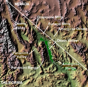
WThe Panamint Valley is a long basin located east of the Argus and Slate ranges, and west of the Panamint Range in the northeastern reach of the Mojave Desert, in eastern California, United States.
 W
Wfor other uses, see Pine Valley (disambiguation)
 W
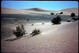
WThe Racetrack Playa, or The Racetrack, is a scenic dry lake feature with "sailing stones" that inscribe linear "racetrack" imprints. It is located above the northwestern side of Death Valley, in Death Valley National Park, Inyo County, California, U.S.A.
 W
WThe Rice Valley is a valley of the southeastern Mojave Desert, located within Riverside County, California.
 W
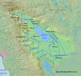
WThe Salton Sink is the low point of an Endorheic basin, a closed drainage system with no outflows to other bodies of water, in the Colorado Desert sub region of the Sonoran Desert. The sink falls within the larger Salton Trough and separates the Coachella Valley from the Imperial Valley, which are also segments of the Salton Trough. The lowest point of the sink is 269 ft (82 m) below sea level, and since 1906 the 343 square miles (890 km2) Salton Sea has filled the lowest portion of the sink to a water depth of up to 43 ft (13 m).
 W
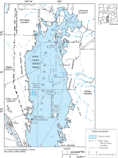
WThe Tularosa Basin is a graben basin in the Basin and Range Province and within the Chihuahuan Desert, east of the Rio Grande in southern New Mexico, in the Southwestern United States.
 W
WThe Ward Valley (California) is a lengthy almost true N-S trending valley of far eastern San Bernardino County, California.
 W
WThe Whitlock Valley is a small valley in southeast Arizona, USA, lying between three mountain ranges. The valley lies on the south perimeter region of the White Mountains in eastern Arizona, and lies south of the west-flowing Gila River, and the region transitions south into Cochise County and three large valleys, with some scattered dry lakes. The valley is endorheic, with a small dry lake called Parks Lake, and merges southwest into the north of the San Simon Valley, where the San Simon River has its origins in the flatlands, and surrounding perimeter mountains. The valley was named after Captain James H. Whitlock who commanded during the Battle of Mount Gray in 1864 which was fought near the valley.
 W
WThe Willcox Playa is a large endorheic dry lake or sink (playa) adjacent to Willcox, Arizona in Cochise County, in the southeast corner of the state. It is part of the Sonoran Desert ecoregion and is the remnant of a Pleistocene era pluvial Lake Cochise. Portions of the dry lake bed have been used as a bombing range by the US military. It was designated a National Natural Landmark in 1966 for its fossil pollen captured underground, the thousands of sandhill cranes that roost in the area and the largest diversity of tiger beetles in the United States.