 W
WThe term bed load or bedload describes particles in a flowing fluid that are transported along the bed. Bed load is complementary to suspended load and wash load.
 W
WIn geomorphology, geography and geology, a bench or benchland is a long, relatively narrow strip of relatively level or gently inclined land that is bounded by distinctly steeper slopes above and below it. Benches can be of different origins and created by very different geomorphic processes.
 W
WA cliff-former is a geological unit of bedrock that is more resistant to erosion than overlying or underlying strata and consequently produces outcrops with high slope angles. It is more or less equivalent to ridge-former, and may be contrasted with slope-former. In humid environments, sandstones are typically cliff-formers. In arid environments, limestones are often cliff-formers also. Recent lavas may be cliff-formers as well.
 W
WA cryptodepression is a depression in the Earth's surface that is below mean sea level, and which is filled by a lake. The term is derived from the Ancient Greek word κρύπτoς ('hidden') and depression.
 W
WEarth Surface Dynamics is a peer-reviewed open access scientific journal published by Copernicus Publications on behalf of the European Geosciences Union. It covers Earth-surface processes, whether physical, chemical, or biological. The editor-in-chief is Tom Coulthard. As of 18 June 2015, it has been accepted by Thompson-Reuters to be indexed in the Science Citation Index Expanded, the Journal Citation Reports, and Current Contents/Physical Chemical and Earth Sciences.
 W
WIn geology and geomorphology, an erosion surface is a surface of rock or regolith that was formed by erosion and not by construction nor fault displacement. Erosional surfaces within the stratigraphic record are known as unconformities, but not all unconformities are buried erosion surfaces. Erosion surfaces vary in scale and can be formed on a mountain range or a rock. Particularly large and flat erosion surfaces receive the names of peneplain, paleoplain, planation surface or pediplain. An example of erosion surface is road surface erosion which is caused by natural and anthropogenic factors. Erosion surface can be measured through direct, contact measurement methods and indirect, non-contact measurement methods.
 W
WA flared slope is a landform consisting in a rock-wall with a smooth transition into a concavity at the foot zone. Flared slopes form due to weathering being more effective at the regolith or soil-covered base of rock walls. These landforms are common in granitic rocks but occur in other rock types as well, such as ignimbrite. Flared slopes can be found in a variety of climates.
 W
WTraditionally in geomorphology, a flatiron is a steeply sloping triangular landform created by the differential erosion of a steeply dipping, erosion-resistant layer of rock overlying softer strata. Flatirons have wide bases that form the base of a steep, triangular facet that narrows upward into a point at its summit. The dissection of a hogback by regularly spaced streams often resulted in the formation of a series of flatirons along the strike of the rock layer that formed the hogback. As noted in some, but not all definitions, a number of flatirons are perched upon the slope of a larger mountain with the rock layer forming the flatiron inclined in the same direction as, but often at a steeper angle than the associated mountain slope. The name flatiron refers their resemblance to an upended, household flatiron.
 W
WA gendarme is a pinnacle of rock on a mountain ridge. They are typical of alpine areas. Gendarmes often form on the intersection of two ridges due to the lower erosion of glaciers here. The name originates from the French Alps, where they were seen as resembling the gendarmerie police.
 W
WHypsometry is the measurement of land elevation. Bathymetry is the underwater equivalent.
 W
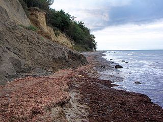
WLand loss is the term typically used to refer to the conversion of coastal land to open water by natural processes and human activities. The term land loss includes coastal erosion. It is much broader term than coastal erosion because land loss also includes land converted to open water around the edges of estuaries and interior bays and lakes and by subsidence of coastal plain wetlands. The most important causes of land loss in coastal plains are erosion, inadequate sediment supply to beaches and wetlands, subsidence, and global sea level rise. The mixture of processes responsible for most of the land loss will vary occurring the specific part of a coastal plain being examined. The definition of land loss does not include the loss of coastal lands to agriculture, urbanization, or other development.
 W
WThe Muddus plains is a landscape type in northern Sweden characterized by its flat topography dotted with inselbergs. The topographic character of the Muddus plains was first described in detail by Walter Wråk in 1908. The Muddus plains are part of the Norrland terrain. The northern lower levels of Southern Norway's Paleic surface are considered to be equivalent to the Muddus plains.
 W
WNiveo-aeolian or cryo-aeolian deposition is the process by which fine-grained sediments are transported by wind and deposited on or mixed with snow or ice. The wind sweeps the snow and sand grains into aeolian forms such as ripples, and further sorts the snow and ice grains into distinct layers When snow melts or sublimates, the sediments are redeposited onto the surface below., forming patterns known as denivation features.
 W
WIn geomorphology a nubbin is a small and gentle hill consisting of a bedrock core dotted with rounded residual blocks. The blocks derive from disintegrated and weathered bedrock layers. In particular it is assumed that the boulders of the nubbins are the remnants of the outer one or two exfoliation shells that weathered underground, albeit some weathering can continue to occur once the boulders are exposed on surface.
 W
WAn outwash fan is a fan-shaped body of sediments deposited by braided streams from a melting glacier. Sediment locked within the ice of the glacier, gets transported by the streams of meltwater, and deposits on the outwash plain, at the terminus of the glacier. The outwash, the sediment transported and deposited by the meltwater and that makes up the fan, is usually poorly sorted due to the short distance traveled before being deposited.
 W
WA slope-former is a unit of bedrock which is less resistant to erosion than overlying or underlying units and consequently results in outcrops with low relative slope angles. It may be contrasted with cliff-former. Typical slope forming lithologies include shales, and limestones in humid environments.
 W
WIn geology, a trough is a linear structural depression that extends laterally over a distance. Although it is less steep than a trench, a trough can be a narrow basin or a geologic rift. These features often form at the rim of tectonic plates. There are various oceanic troughs, troughs found under oceans.
 W
WA drift line or wrack line, also known as a wash margin or wash fringe is an area of the shore on which material is deposited or washed up. It often runs along the margin of a waterbody and there can be several bands due to variations in water levels. As a result of the richness of nutrients that occur in such wash fringes, ruderal species frequently occur here, that, for example, on the Baltic Sea coast consist of grassleaf orache and sea kale.
 W
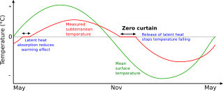
WThe zero-curtain effect occurs in cold environments where the phase transition of water to ice is slowed due to latent heat release. The effect is notably found in arctic and alpine permafrost sediments, and occurs where the air temperature falls below 0°C followed by a rapid drop in soil temperature.