 W
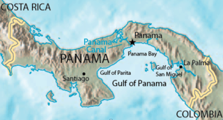
WThe Gulf of Panama is a gulf in the Pacific Ocean, near the southern coast of Panama. It has a maximum width of 250 kilometres (160 mi), a maximum depth of 220 metres (720 ft) and the size of 2,400 square kilometres (930 sq mi). The Panama Canal connects the Gulf of Panama with the Caribbean Sea and the Pacific Ocean. The Panamanian capital Panama City is the main urban centre on the gulf shore.
 W
WThe Causeway Islands are four small islands by the Pacific entrance to the Panama Canal. They are linked to the mainland via a causeway, made from rock extracted during the excavations from the Panama Canal. In part the causeway was meant to serve as a breakwater for the entrance.
 W
WAzuero Peninsula is a large peninsula in southern Panama. It is surrounded by the Pacific Ocean in the south; the Pacific and Gulf of Montijo to the west, and by the Gulf of Panama in the east. The peninsula is effectively divided into two regions; the Western Azuero and the Eastern Azuero, as no serviceable roads join the two peninsula regions past the Pan-American Highway.
 W
WThe Bay of San Miguel is a bay of the Gulf of Panama, located on the Pacific coast of Darién Province in eastern Panama.
WThe Causeway Islands are four small islands by the Pacific entrance to the Panama Canal. They are linked to the mainland via a causeway, made from rock extracted during the excavations from the Panama Canal. In part the causeway was meant to serve as a breakwater for the entrance.
 W
WThe Chepo River is a river of Panama in the Chepo District of Panama Province. It drains into the Pacific Ocean.
 W
WIsla Contadora is a Panamanian island on the Pearl Islands archipelago in the Gulf of Panama. It has an area of 1.39 km², which makes it the 11th largest island of the archipelago. With a population of 253, however, it ranks third, after Isla del Rey and Isla Taboga. A popular tourist destination, Contadora has a small regional/domestic airport, and has regular flights to and from Panama City and the rest of the islands in the archipelago.
 W
WThe Rio Grande (Panama) is a river in Coclé Province in Panama.
 W
WThe Gulf of Panama mangroves (NT1414) is an ecoregion along the Pacific coast of Panama, Colombia. The mangroves experience seasonal flooding with high levels of sediment, and occasional extreme storms or very low rainfall due to El Niño effects. They are important as a breeding or nursery area for marine species. Areas of the mangroves have been recognized as Important Bird Areas and Ramsar wetlands. The ecoregion has been severely degraded by clearance of mangroves for agriculture, pasturage and shrimp farming, by urban pressure around Panama City, and by pollution related to the Panama Canal.
WGulf of Parita or Parita Bay is a large gulf off the coast of Herrera Province, in Panama.
 W
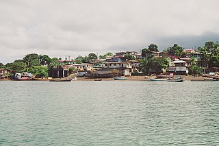
WIsla del Rey is the largest island in the Pearl Islands in the Gulf of Panama. It has an area of 234 square kilometres (90 sq mi), and a population of 1,676. Its current name is probably more a reference to Christ the King than to a secular king. There are four towns, which are San Miguel, La Esmeralda, La Ensenada and La Guinea. It is easily larger than the other Pearl Islands combined, and is the second largest island in Panama, after Coiba.
 W
WIsla Gibraleón is a small, uninhabited Panamanian island that is part of the Pearl Islands archipelago in the Gulf of Panama. It is located 2 km (1.2 mi) west of Isla Casaya, and is part of a group of 200 or more islands and islets lying about 30 miles (48 km) off the Pacific coast of Panama. The island has an eight-kilometre (5.0-mile) coastline, five beaches, a mangrove swamp, and is covered in 153.18 acres (61.99 ha) of dense jungle. It has a total surface area of 277.62 acres (112.35 ha), which makes it the 12th largest island in the archipelago. Isla Gibraleón rises to a height of 11 metres (36 ft) above sea level, and is in the Eastern Time Zone (UTC−05:00).
 W
WLas Tablas is the capital of the Panamanian province of Los Santos, with a population of 9,255 as of 2010. It is located a few kilometres inland from the Gulf of Panama on the Azuero Peninsula. Las Tablas is a recognised national centre of Panamanian folk: Art, music, gastronomy, architecture, culture and literature. The only Panamanian president to serve three terms, Belisario Porras, was from Las Tablas.
 W
WOtoque is an island located in the Gulf of Panama. It belongs to the Taboga District. It has an area of 2.66 km². At the census 2000, the population was 130. The island was originally inhabited by indigenous groups led by chiefs Careta, Tatalao and Estivá, which fought against the Spanish conquerors. Currently, the population of the island consists of a racial mixture. This population is divided into two groups located at opposite places of the island: the districts of East Otoque and West Otoque. The economy of this island is based mainly on fishing and subsistence agriculture.
 W
WThe South American Pacific mangroves, or Panama Bight mangroves, is an ecoregion along the Pacific coast of Panama, Colombia, Ecuador and Peru.
 W
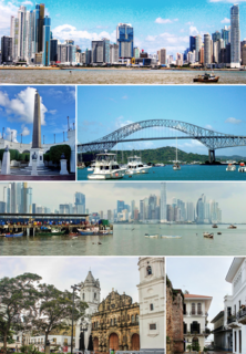
WPanama City, also simply known as Panama, is the capital and largest city of Panama. It has an urban population of 880,691, with over 1.5 million in its metropolitan area. The city is located at the Pacific entrance of the Panama Canal, in the province of Panama. The city is the political and administrative center of the country, as well as a hub for banking and commerce.
WThe Pearl Islands is a group of 200 or more islands and islets lying about 30 miles (48 km) off the Pacific coast of Panama in the Gulf of Panama.
WThe South American Pacific mangroves, or Panama Bight mangroves, is an ecoregion along the Pacific coast of Panama, Colombia, Ecuador and Peru.
 W
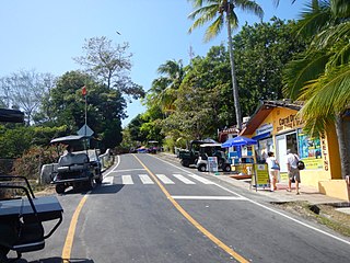
WTaboga Island, also known as the "Island of Flowers", is a volcanic island in the Gulf of Panama. It is a tourist destination, about 20 km from Panama City, Panama.