 W
WThe Ambracian Gulf, also known as the Gulf of Arta or the Gulf of Actium, and in some official documents as the Amvrakikos Gulf, is a gulf of the Ionian Sea in northwestern Greece. About 40 km (25 mi) long and 15 km (9 mi) wide, it is one of the largest enclosed gulfs in Greece, and due to its ecological importance is one of the National Parks of Greece. The towns of Preveza, Amphilochia, and Vonitsa lie on its shores.
 W
WThe Argolic Gulf, also known as the Gulf of Argolis or Gulf of Nafplio, is a gulf of the Aegean Sea off the east coast of the Peloponnese, Greece. It is about 50 km long and 30 km wide. Its main port is Nafplio, at its northwestern end. At the entrance to the gulf is the island Spetses. This gulf and its islands are sometimes combined with the Saronic Gulf and Saronic Islands, with the result called the Argo-Saronic Gulf and the Argo-Saronic Islands. It is surrounded by two regional units: Arcadia to the southwest and Argolis to the north and east. The river Inachos drains into the Argolic Gulf near Nea Kios. The main islands in the gulf are Psili, Plateia and Bourtzi, a small island with a Venetian fortress that protects the port of Nafplio. The surrounding mountains protect it from the strong summer Meltemi wind.
 W
WThe Gulf of Chania is an embayment of the Sea of Crete in the northwestern region of the island of Crete in present-day Greece. One headland forming the Gulf of Chania is the promontory known as the Akrotiri Peninsula.
 W
WThe Gulf of Kyparissia is a long, curving indentation along the western coast of the Peloponnese peninsula, Greece. It lies between Cape Katakolo at the north end and Cape Konello to the south. Near the northern extreme is the city of Pyrgos, with the town of Zacharo near the center and the town of Kyparissia lying toward the southern end. Flowing into the gulf are the Alpheios and Neda rivers. Its southern part is also one of the main breeding grounds of the endangered loggerhead sea turtle.
 W
WThe Laconian Gulf, is a gulf in the south-eastern Peloponnese, in Greece. It is the southernmost gulf in Greece and the largest in the Peloponnese.
 W
WThe Malian or Maliac Gulf is a gulf in the western Aegean Sea. It forms part of the coastline of Greece's region of Phthiotis. The gulf stretches east to west to a distance of 15 to 22 kilometers, depending on the definition, and is very shallow, with a maximum depth of 27 meters (89 ft). The only harbour is that of Stylida, which serves the city of Lamia. To its east is Cape Lichada, the northwesternmost point of the island of Euboea.
 W
WThe Megara Gulf is a gulf in the Aegean Sea. It forms the northern section of the Saronic Gulf.
 W
WThe Messenian Gulf is a sea that is part of the Ionian Sea. The gulf is circumscribed by the southern coasts of Messenia and the southwestern coast of the Mani peninsula in Laconia. Its bounds are Venetiko Island to the west and Cape Tainaron to the southeast. The western shores are mostly low-lying, fertile and well-developed, while the eastern shore is dominated by the southern foothills of the Taygetos and comparatively rocky and inaccessible, with few settlements.
 W
WThe Molos Gulf is a bay of the Ionian Sea on the east coast of the island Ithaca, western Greece. It penetrates deep into the island and cuts it nearly into two parts, that are only connected by the 620 m wide isthmus of Aetos.
 W
WThe Myrtos Gulf is a gulf on the north coast of the island Cephalonia, Greece. It is a bay of the Ionian Sea. The main villages on its shore are Asos and Zola. The total length is approximately 10 km long and is approximately 10 km wide. It stretches from Cape Kakata to Asos from east to west and from Zola to the Asos Peninsula to the north. The gulf has a mountainous coast. There are no ferry routes in this gulf.
 W
WThe Pagasetic Gulf is a rounded gulf in the Magnesia regional unit that is formed by the Mount Pelion peninsula. It is connected with the Euboic Sea. The passage into the Euboic Sea is narrow and is about 4 km.
 W
WThe Gulf of Patras is a branch of the Ionian Sea in Western Greece. On the east, it is closed by the Strait of Rion between capes Rio and Antirrio, near the Rio-Antirrio bridge, that is the entrance of the Gulf of Corinth. On the west, it is bounded by a line from Oxeia island to Cape Araxos. To the north it is bounded by the shore of Aetolia-Acarnania in continental Greece, and to the south by Achaea in the Peloponnese peninsula. It is 40–50 km (25–31 mi) long, 10–20 km (6.2–12.4 mi) wide, and has an area of 350–400 km2.
 W
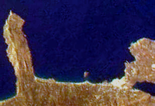
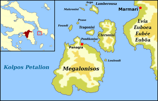
WThe Petalioi Gulf is a gulf of the Aegean Sea, Greece. It stretches between the east coast of Attica and the south tip of the island Euboea. It takes its name from the Petalioi islands, that are situated in the northeastern part of the Gulf, off the Euboean coast. The Petalioi Gulf is connected to the South Euboean Gulf to the north. Its length is approximately 50 km long from north to south and its width is approximately 5 km in the north to about 50 km in the south. There are several uninhabited islands in the gulf, including the Petalioi and Makronisos. Promontories include Strongylo and Vigla in the island of Euboea.
WThe Saronic Gulf or Gulf of Aegina in Greece is formed between the peninsulas of Attica and Argolis and forms part of the Aegean Sea. It defines the eastern side of the isthmus of Corinth, being the eastern terminus of the Corinth Canal, which cuts across the isthmus. The Saronic Islands in the gulf have played a pivotal role in the history of Greece, with the largest, Salamis, naming a significant naval battle in the Greco-Persian wars. The Megara Gulf makes up the northern end of the Saronic Gulf.
 W
WThe Singitic Gulf, also known as the Mount Athos Gulf or the Holy Mountain Gulf is a gulf of the Thracian Sea, part of the northern Aegean Sea, in Chalkidiki, Greece. It is bounded by Sithonia in the west, and Mount Athos in the east. The island of Ammouliani sits in the northeastern portion of the gulf along Mount Athos. Many of the monasteries of Mount Athos lie along the shore of the Singitic Gulf.
 W
WThe South Euboean Gulf is a gulf in Central Greece, between the island of Euboea and the Greek mainland. With a total length of approximately 50 km and a width of 10 to 20 km, it stretches nearly diagonally from northwest to southeast, from the Euripus Strait, which connects it to the North Euboean Gulf, to the Petalies Gulf near Agia Marina in the south.
 W
WThe Strymonian or Strymonic Gulf, also known as the Orfano Gulf, is a branch of the Thracian Sea—itself part of the Aegean Sea—lying east of the Chalcidice peninsula and south of the Serres regional unit. It was formerly known as the Gulf of Rendina, in reference to the ancient colony of Eion along the gulf's shores.
 W
WThe Thermaic Gulf, also called the Gulf of Salonika and the Macedonian Gulf, is a gulf constituting the northwest corner of the Aegean Sea. The city of Thessaloniki is at its northeastern tip, and it is bounded by Pieria and Imathia on the west and the Chalkidiki peninsula on the east, with Cape Kassandra at the southeasternmost corner. It is named after the ancient town of Therma, modern Thessaloniki. It is about 100 km (62 mi) long.
WThe Toronean Gulf or Toroneos Gulf, also known as the Kassandra Gulf, is a gulf of the Thracian Sea, part of the northern Aegean Sea, in Chalkidiki, Greece. It lies between the Kassandra peninsula in the west, and Sithonia in the east.