 W
WThe Gunnison River is a tributary of the Colorado River, 180 miles (290 km) long, in the Southwestern state of Colorado. It is the largest tributary of the Colorado River in Colorado, with a mean flow of 2,570 cu ft/s (73 m3/s).
 W
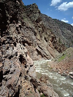
WBlack Canyon of the Gunnison National Park is an American national park located in western Colorado and managed by the National Park Service. There are two primary entrances to the park: the south rim entrance is located 15 miles (24 km) east of Montrose, while the north rim entrance is 11 miles (18 km) south of Crawford and is closed in the winter. The park contains 12 miles (19 km) of the 48-mile (77 km) long Black Canyon of the Gunnison River. The national park itself contains the deepest and most dramatic section of the canyon, but the canyon continues upstream into Curecanti National Recreation Area and downstream into Gunnison Gorge National Conservation Area. The canyon's name owes itself to the fact that parts of the gorge only receive 33 minutes of sunlight a day, according to Images of America: The Black Canyon of the Gunnison. In the book, author Duane Vandenbusche states, "Several canyons of the American West are longer and some are deeper, but none combines the depth, sheerness, narrowness, darkness, and dread of the Black Canyon."
 W
WBlue Mesa Reservoir is an artificial reservoir located on the upper reaches of the Gunnison River in Gunnison County, Colorado. The largest lake located entirely within the state, Blue Mesa Reservoir was created by the construction of Blue Mesa Dam, a 390-foot tall earthen fill dam constructed on the Gunnison by the U.S. Bureau of Reclamation in 1966 for the generation of hydroelectric power. Managed as part of the Curecanti National Recreation Area, a unit of the National Park Service, Blue Mesa Reservoir is the largest lake trout and Kokanee salmon fishery in Colorado.
 W
WThe Cimarron River is a 22.0-mile-long (35.4 km) tributary that joins the Gunnison River in Curecanti National Recreation Area near Cimarron, Colorado. The river's source is the confluence of two forks near Silver Jack Reservoir in the Uncompahgre National Forest.
 W
WCimarron is an unincorporated community and U.S. Post Office in Montrose County, Colorado, United States. The Cimarron Post Office has the ZIP Code 81220.
 W
WCrystal Reservoir is a 340-acre artificial reservoir on the Gunnison River in western Colorado. Located in the upper Black Canyon of the Gunnison, the lake was created in 1976 by the U.S. Bureau of Reclamation as part of a larger plan to impound the upper section of the Gunnison for the generation of hydroelectric power, water storage, and public recreation. Crystal Reservoir is managed by the National Park Service as an element of the Curecanti National Recreation Area. Located at the far western end of Curecanti, Crystal Reservoir is the smallest, least developed, and least accessible of the three reservoirs within the park.
 W
WCurecanti National Recreation Area is a National Park Service unit located on the Gunnison River in western Colorado. Established in 1965, Curecanti is responsible for developing and managing recreational facilities on three reservoirs, Blue Mesa Reservoir, Morrow Point Reservoir and Crystal Reservoir, constructed on the upper Gunnison River in the 1960s by the U.S. Bureau of Reclamation to better utilize the vital waters of the Colorado River and its major tributaries. A popular destination for boating and fishing, Curecanti offers visitors two marinas, traditional and group campgrounds, hiking trails, boat launches, and boat-in campsites. The state's premiere lake trout and Kokanee salmon fisheries, Curecanti is a popular destination for boating and fishing, and is also a popular area for ice-fishing in the winter months.
 W
WThe Denver and Rio Grande Railroad's Cimarron Canyon trestle, listed as D&RG Narrow Gauge Trestle on the National Register of Historic Places, is a narrow-gauge railroad deck truss bridge crossing the Cimarron River, within the Curecanti National Recreation Area near Cimarron, Colorado.
 W
WDelta is the Home Rule Municipality that is the county seat and the most populous municipality of Delta County, Colorado, United States. The population was 8,915 at the 2010 census, up from 6,400 at the 2000 census. The United States Forest Service headquarters of the Grand Mesa, Gunnison, and Uncompahgre National Forests are located in Delta.
 W
WThe Gunnison Gorge National Conservation Area is a 62,844-acre (254.32 km2) National Conservation Area located in west-central Colorado near Montrose. It is managed by the Bureau of Land Management (BLM) as part of the National Landscape Conservation System. 57,725 acres (233.60 km2) were designated in the Black Canyon of the Gunnison National Park and Gunnison Gorge National Conservation Area Act of 1999. The Black Canyon of the Gunnison Boundary Revision Act of 2003 expanded the NCA to its current size.
 W
WThe Gunnison Gorge Wilderness is a U.S. Wilderness Area located immediately northwest of the Black Canyon of the Gunnison National Park. The 17,784-acre (71.97 km2) wilderness area established in 1999 includes 14 miles (23 km) of the Gunnison River inside the Gunnison Gorge National Conservation Area.
 W
WThe Gunnison National Forest is a U.S. National Forest covering 1,672,136 acres in Mesa, Gunnison, Hinsdale and Saguache Counties in Western part of the U.S. state of Colorado. It borders the White River National Forest to the north, the Grand Mesa and Uncompahgre National Forests to the west, the San Isabel National Forest to the east and the Rio Grande National Forest to south. It lies in parts of five counties. In descending order of land area within the forest they are Gunnison, Saguache, Hinsdale, Delta, and Montrose counties.
WThe Gunnison Tunnel is an irrigation tunnel constructed between 1905 and 1909 by the U.S. Bureau of Reclamation in Montrose County, Colorado. The 5.8 mile long tunnel diverts water from the Gunnison River to the arid Uncompahgre Valley around Montrose, Colorado.
 W
WLake Fork Gunnison River or Lake Fork is a 64.7-mile-long (104.1 km) tributary of the Gunnison River in Colorado. The river's source is Sloan Lake near Handies Peak in the San Juan Mountains of Hinsdale County. Lake Fork flows through Lake San Cristobal and Lake City before a confluence with the Gunnison River in Blue Mesa Reservoir.
 W
WMiddle Bridge is the crossing of Blue Mesa Reservoir on U.S. Route 50 (US 50) within the Curecanti National Recreation Area in southwest Gunnison County, Colorado, United States, about 2.5 miles (4.0 km) east-northeast of the community of Sapinero.
 W
WMorrow Point Reservoir is an 817-acre artificial reservoir on the Gunnison River in western Colorado. Located in the upper Black Canyon of the Gunnison, the lake was created in 1968 by the U.S. Bureau of Reclamation as part of a larger plan to impound the upper section of the Gunnison and create opportunities for hydroelectric power generation, water conservation, and recreation. Morrow Point Reservoir is managed by the National Park Service as a unit within the Curecanti National Recreation Area, and is the location of the Curecanti Needle, a striking 700 ft. granite spire on the reservoir's southern bank whose unique shape was for decades a recognized symbol of the Denver and Rio Grande Western Railroad.
 W
WThe North Fork Gunnison River is a tributary of the Gunnison River, 33.5 miles (53.9 km) long, in southwestern Colorado in the United States. It drains part of the southwestern flank of the Elk Mountains northeast of Delta.
 W
WSmith Fork is a tributary of the Gunnison River that flows in Gunnison and Delta counties in western Colorado. The river is signed as "Smith Fork Creek" where it goes under Colorado State Highway 92 in Crawford, Colorado.
 W
WThe Uncompahgre River is a tributary of the Gunnison River, approximately 75 mi (121 km) long, in southwestern Colorado in the United States. Lake Como at 12,215 ft (3723m) in northern San Juan County, in the Uncompahgre National Forest in the northwestern San Juan Mountains is the headwaters of the river. It flows northwest past Ouray, Ridgway, Montrose, and Olathe and joins the Gunnison at Confluence Park in Delta.