 W
WKootenay National Park is a national park located in southeastern British Columbia, and is one component of the Canadian Rocky Mountain Parks World Heritage Site. The park consists of 1,406 km2 (543 sq mi) of the Canadian Rockies, including parts of the Kootenay and Park mountain ranges, the Kootenay River and the entirety of the Vermilion River. While the Vermilion River is completely contained within the park, the Kootenay River has its headwaters just outside the park boundary, flowing through the park into the Rocky Mountain Trench, eventually joining the Columbia River. It ranges in elevation from 918 m (3,012 ft) at the southwestern park entrance, to 3,424 m (11,234 ft) at Deltaform Mountain. Initially called "Kootenay Dominion Park", the park was created in 1920 as part of an agreement between the province of British Columbia and the Canadian federal government to build a highway in exchange for title to a strip of land, approximately 8 km (5.0 mi) on either side of the 94 km route, the Banff–Windermere Highway, to be used solely for park purposes. While the park is open all year, the major tourist season lasts from June to September. Most campgrounds are open from early May to late September, while limited winter camping is available only at the Dolly Varden campground.
 W
WBeatrice Peak is a peak located on the Continental Divide on the border of Banff and Kootenay National Parks, between Stanley Peak and Mount Ball. The mountain was named in 1912 by the Alpine Club of Canada after Beatrice Shultz who climbed the mountain that year.
 W
WMount Bowlen is located on the border of Alberta and British Columbia and forms part of the Valley of the Ten Peaks. It was named in 1953 after John J. Bowlen, a native of Prince Edward Island, successful Alberta rancher, honorary chief of the Blackfoot, and a Lieutenant Governor of Alberta. Its former name was "Yamnee", which translates to the number 3 in the local Nakoda (Stoney) language.
 W
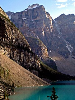
WDeltaform Mountain is one of the mountains in the Valley of the Ten Peaks, located on the Continental Divide on the border of British Columbia and Alberta, and also on the border between Banff and Kootenay National Parks in Canada. The mountain was originally named Saknowa by Samuel Allen but Walter Wilcox named it to its official title in 1897 as it resembles the Greek letter delta.
 W
WDivision Mountain is located on the Continental Divide along the Alberta - British Columbia border of Canada. It also straddles the shared boundary of Banff National Park with Kootenay National Park in the Canadian Rockies. It was named in 1919 by Charles D. Walcott since the mountain divides the Lyell Icefield from the Mons Icefield.
 W
WThe Fay hut was an alpine hut located above Prospectors Valley in Kootenay National Park, British Columbia. Although the higher Neil Colgan hut superseded it as a base for climbs in the Valley of the Ten Peaks area, it still served as a convenient base for hikers and skiers doing day trips in the area, and as an overnight stop for mountaineers continuing on to the Neil Colgan hut. A new hut was built in 2005 to replace the original Fay hut, which was destroyed by a forest fire in 2003. The Fay hut was maintained by the Alpine Club of Canada (ACC).
 W
WFloe Lake is a lake in Kootenay National Park, British Columbia, Canada. The lake is only accessible by a 10.7 km hiking trail that leaves from a marked trailhead on highway 93.
 W
WThe Great Divide Trail (GDT) is a wilderness hiking trail in the Canadian Rockies. The trail closely follows the Great Divide between Alberta and British Columbia, crossing the divide more than 30 times. Its southern terminus is in Waterton Lakes National Park at the Canada–US border and its northern terminus is at Kakwa Lake in Kakwa Provincial Park, north of Jasper National Park. The trail is 1,130 km (700 mi) long and ranges in elevation from 1,055 m (3,461 ft) at Old Fort Point trailhead near Jasper to 2,590 m (8,500 ft) at an unnamed pass above Michele Lakes just south of the White Goat Wilderness Area.
 W
WHelmet Falls is a tiered waterfall located in Kootenay National Park in British Columbia, Canada. With total height of 352 metres (1,155 ft), Helmet Falls is the 11th tallest confirmed waterfall in the Canadian Rockies, as well as one of the most significant waterfalls in British Columbia based on both height and volume.
 W
WHewitt Peak is a 3,066-metre (10,060-foot) mountain summit located on the western border of Kootenay National Park, in the Canadian Rockies of British Columbia, Canada. The peak is also known locally as Mammoth Peak, and originally as Mount 10060. The alternate names derive from its outline profile resembling a mammoth, and its elevation as measured in feet. No name for this mountain has been officially adopted yet. Its nearest higher peak is Tumbling Peak, 2.5 km (1.6 mi) to the north-northwest, and both are part of the Vermilion Range. Park visitors can catch a glimpse of the peak from Highway 93, also known as the Banff–Windermere Highway.
 W
WIsabelle Peak is a peak located on the Continental Divide on the border of Banff and Kootenay National Parks in the Canadian Rockies.
 W
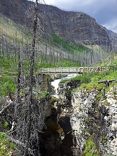
WMarble Canyon is a canyon surrounding Tokumm Creek just above its confluence with the Vermilion River, at the north end of Kootenay National Park in the Canadian Rockies of British Columbia, Canada. South of Marble Canyon on Highyway 93 is Numa Falls on the Vermillion River."[Tokumm Creek] joins Vermillion River through a magnificent gorge, or box canyon, so narrow that at several places the fissure, for it seems little more than a crack in the rock strata, is bridged by great boulders that have become wedged across it. It was a feature well worth seeing."
 W
WThe Neil Colgan Hut is an alpine hut on the Fay Glacier in Kootenay National Park in British Columbia, Canada. It is in a col between Mount Little and Mount Bowlen, one of the peaks overlooking the Valley of the Ten Peaks. The hut is maintained by the Alpine Club of Canada and is the highest permanent structure in Canada. It is named for hiker and adventurer Neil M. Colgan.
 W
WNuma Falls is a waterfall of the Vermilion River located in Kootenay National Park, British Columbia, Canada.
 W
WQuadra Mountain is located on the border of Alberta and British Columbia on the Continental Divide. It was named in 1910 by Arthur Oliver Wheeler. The name refers to the mountain's four pinnacles. However, in 1952 the form of the name was changed to Mount Quadra in the mistaken belief that it had been named after Juan Francisco de la Bodega y Quadra—mountains named for people taking the form "Mount Person's Name". In 1983 the form was changed back to Quadra Mountain by British Columbia and Alberta, and in 1984 by Parks Canada.
 W
WStanley Peak is a 3,155-m-high mountain located in the Ball Range, at the northeastern section of Kootenay National Park, in the Canadian Rocky Mountains. The mountain was named in 1901 by its first climber, the English explorer Edward Whymper, after Frederick Stanley, 16th Earl of Derby, the sixth Governor-General of Canada. There are sources that date the naming in 1912 after Stanley H. Mitchell, Secretary-Treasurer of Alpine Club of Canada.
 W
WStorm Mountain is a 3,158-metre (10,361-foot) mountain summit located on the Continental Divide on the shared border of Alberta and British Columbia in Canada. It is situated on the shared boundary of Kootenay National Park with Banff National Park in the Canadian Rockies. It is a large peak near the north end of the Ball Range, in the Bow River Valley opposite Castle Mountain. Vermilion Pass is situated to the northwest of the mountain, and Stanley Peak to the southwest. The nearest higher peak is Mount Ball, 5.7 km (3.5 mi) to the south.
 W
WTumbling Peak is a 3,145-metre (10,318-foot) mountain summit located on the western border of Kootenay National Park in the Vermilion Range, which is a sub-range of the Canadian Rockies of British Columbia, Canada. The mountain takes its name from the Tumbling Glacier located on its northeast flank. Its nearest higher peak is Foster Peak, 6.8 km (4.2 mi) to the southeast. Hewitt Peak is also to the southeast, and Mount Gray is to the immediate northwest. The mountain is situated in an area known as the Rockwall, which is an escarpment of the Vermilion Range. The Rockwall Trail is a scenic 55 kilometers traverse of alpine passes, sub-alpine meadows, hanging glaciers, and limestone cliffs, in some places in excess of 900 meters above the trail.
 W
WVermilion Peak is a 2,647-metre (8,684-foot) mountain summit located in the Vermilion River Valley of Kootenay National Park, in British Columbia, Canada. It is part of the Ball Range, which is a sub-range of the Canadian Rockies. Its nearest higher peak is Stanley Peak, 2.8 km (1.7 mi) to the east. Vermilion Peak can be seen from the Banff–Windermere Parkway as it traverses the base of the mountain.