 W
WCorvo Island, literally the Island of the Crow, is the smallest and the northernmost island of the Azores archipelago and the northernmost in Macaronesia, has a population of approximately 468 inhabitants constituting the smallest single municipality in the Azores and in Portugal, and lies within the North American Plate.
 W
WFaial Island, also known in English as Fayal, is a Portuguese island of the Central Group of the Azores. The Capelinhos Volcano, the westernmost point of the island, may be considered the westernmost point of Europe, if the Monchique Islet, near Flores Island, is considered part of North America, for it sits on the North American Plate. Its largest town is Horta.
 W
WFlores Island is an island of the Western group of the Azores. It has an area of 143 km², a population of approximately 3907 inhabitants, and, together with Corvo Island of the western archipelago, lies within the North American Plate. The nearby Monchique Islet is the westernmost point of Portugal. It has been referred to as the Ilha Amarelo Torrado by marketing and due to the association with poet Raul Brandão, but it is well known for its abundance of flowers, hence its Portuguese name of Flores.
 W
WWith an elevation of 902 metres (2,959 ft) and a topographic prominence of 739 metres (2,425 ft), Fóia is the highest mountain of Algarve, Portugal. It is part of the Serra de Monchique range and is located at 37.314795°N 8.596244°W within Monchique parish.
 W
WFurnas is a civil parish in the municipality of Povoação on the island of São Miguel in the Portuguese Azores. The population in 2011 was 1,439, in an area of 34.43 km². The parish is one of the largest in the island and in the Azores. It is located east of Lagoa and Ponta Delgada, west of Povoação and southeast of Ribeira Grande.
 W
WThe Gardunha mountain range, so called by the Moors, is located in central Portugal, in Centro Region, beyond the Serra da Estrela range, giving way to an extensive plain called Beira Baixa Province. It was covered with vineyards in the time of King Denis, who reigned in the 13th and 14th centuries. But the sovereign decided to pull them up and replace them with chestnut trees all over the Alcambar valley. The valley became known as the King's groves. Unfortunately though, due to man's negligence, violent fires destroyed a significant number of trees, although some areas were reforested. Pirâmide (1,223m/4,013ft), is the highest point in Gardunha mountain range.
 W
WGraciosa Island is referred to as the White Island, the northernmost of the Central Group of islands in the Azores. The ovular Portuguese island has an area of 60.65 square kilometres, a length of 10 kilometres and a width of 7 kilometres. It is a volcanic island, dominated by a 1.6-kilometre-wide (1.0-mile) central caldera located in the southeast.
 W
WThis is a list of the mountains in Portugal, including the mountains with more than 1400 meters of altitude and with, at least, 100 meters of topographic prominence.
 W
WMorre Alto is the highest mountain of Flores, Azores, Portugal.
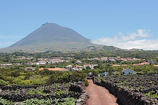
WMount Pico is a stratovolcano located on Pico Island, in the mid-Atlantic archipelago of the Azores. It is the highest mountain of Portugal, at 2,351 metres (7,713 ft) above sea level, and is one of the highest Atlantic mountains; it is more than twice the elevation of any other peak in the Azores.
 W
WPico Island, is an island in the Central Group of the Portuguese Azores. The landscape features an eponymous volcano, Ponta do Pico, which is the highest mountain in Portugal, the Azores, and the highest elevation of the Mid-Atlantic Ridge. In the tradition of the Portuguese poet, Raul Brandão, Pico is referred to as the Ilha Preta, for its black volcanic earth, responsible for its UNESCO-designated historical vineyards that allowed the development of the island.
 W
WPico da Esperança is the highest mountain of São Jorge Island, Azores. Its elevation is 1,053 m. It is situated in the Norte Grande parish, Velas municipality.
 W
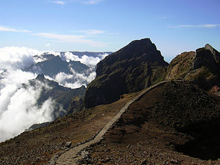
WPico do Arieiro, at 1,818 m (5,965 ft) high, is Madeira Island's third highest peak. Most days, visitors can stand and look down on the clouds. The air is fresh and clear and the sun is very bright. On a clear day it is possible to see the neighbouring island of Porto Santo, 30 miles to the northeast.
 W
WPico Ruivo is the highest peak on Madeira Island. It can be reached only by foot, usually either from Pico do Arieiro after a strenuous hike, or from Achada do Teixeira via a shorter, easier trail. There is an additional trail leading west to Encumeada. The hut just below the summit is now open, and there are water tap and toilets available.
 W
WThe Rock of the Three Kingdoms is a mountain of 1025 m of elevation in the Serra de Marabón, part of the mountainous system of Sierra de la Culebra.
 W
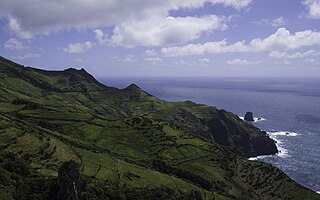
WSão Jorge is an island in the central group of the Azores archipelago and part of the autonomous region of Portugal. Separated from its nearest neighbors by the 15-kilometre (9.3 mi) Pico-São Jorge Channel, the central group is often referred colloquially as part of the Triangulo ("Triangle") group or just "The Triangle". São Jorge is a relatively long thin island with tall cliffs, whose 9500 inhabitants are concentrated on various geological debris fields (fajãs) along the north and south coasts; from east to west, the island is 53 kilometres (33 mi) long and, north to south, 8 kilometres (5.0 mi) wide: its area is 237.59 square kilometres (91.73 sq mi).
 W
WSete Cidades is a civil parish in the center of the municipality of Ponta Delgada, that is likewise located in the center of a massive volcanic crater three miles across, also referred to as Sete Cidades. The population in 2011 was 793, in an area of 19.19 km². It is one of the smallest parishes of Ponta Delgada by population, although the largest in area. It contains the localities Cerrado da Ladeira, Cerrado das Freiras and Sete Cidades.
 W
WTerceira is a volcanic island in the Azores archipelago, in the middle of the North Atlantic Ocean. It is one of the larger islands of the archipelago, with a population of 56,000 inhabitants in an area of approximately 396.75 square kilometres. It is the location of the Azores' oldest city, Angra do Heroísmo, the historical capital of the archipelago and UNESCO World Heritage Site; the seat of the judicial system ; and the main Air Force base, Base Aérea nº 4 at Lajesse, with a United States Air Force detachment.
 W
WPico das Torres is the second highest peak on the Atlantic island of Madeira, Portugal. It lies roughly midway between the Pico Ruivo and Pico do Arieiro at an elevation of 1,853 metres (6,079 ft) and is only accessible from the trail between these two peaks.