 W
WThe polar regions, also called the frigid zones, of Earth are the regions of the planet that surround its geographical poles, lying within the polar circles. These high latitudes are dominated by floating sea ice covering much of the Arctic ocean in the north, and by the Antarctic ice sheet on the continent of Antarctica in the South.
 W
WAntarctica is Earth's southernmost continent. It contains the geographic South Pole and is situated in the Antarctic region of the Southern Hemisphere, almost entirely south of the Antarctic Circle, and is surrounded by the Southern Ocean. At 14,200,000 square kilometres, it is the fifth-largest continent and nearly twice the size of Australia. At 0.00008 people per square kilometre, it is by far the least densely populated continent. About 98% of Antarctica is covered by ice that averages 1.9 km in thickness, which extends to all but the northernmost reaches of the Antarctic Peninsula.
 W
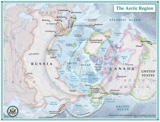
WThe Arctic is a polar region located at the northernmost part of Earth. The Arctic consists of the Arctic Ocean, adjacent seas, and parts of Alaska, Canada, Finland, Greenland (Denmark), Iceland, Norway, Russia, and Sweden. Land within the Arctic region has seasonally varying snow and ice cover, with predominantly treeless permafrost containing tundra. Arctic seas contain seasonal sea ice in many places.
 W
WAn aurora, sometimes referred to as polar lights, northern lights, or southern lights, is a natural light display in the Earth's sky, predominantly seen in high-latitude regions.
 W
WA circumpolar distribution is any range of a taxon that occurs over a wide range of longitudes but only at high latitudes; such a range therefore extends all the way around either the North Pole or the South Pole. Taxa that are also found in isolated high-mountain environments further from the poles are said to have arctic–alpine distributions.
 W
WA geographical pole or geographic pole is either of the two points on Earth where its axis of rotation intersects its surface. The North Pole lies in the Arctic Ocean while the South Pole is in Antarctica. North and South poles are also defined for other planets or satellites in the Solar System, with a North pole being on the same side of the invariable plane as Earth's North pole.
 W
WThe North Magnetic Pole is a point on the surface of Earth's Northern Hemisphere at which the planet's magnetic field points vertically downwards. There is only one location where this occurs, near the Geographic North Pole. The Geomagnetic North Pole, a related point, is the pole of an ideal dipole model of the Earth's magnetic field that most closely fits the Earth's actual magnetic field.
WThe North Magnetic Pole is a point on the surface of Earth's Northern Hemisphere at which the planet's magnetic field points vertically downwards. There is only one location where this occurs, near the Geographic North Pole. The Geomagnetic North Pole, a related point, is the pole of an ideal dipole model of the Earth's magnetic field that most closely fits the Earth's actual magnetic field.
 W
WThe North Pole, also known as the Geographic North Pole or Terrestrial North Pole, is defined as the point in the Northern Hemisphere where the Earth's axis of rotation meets its surface. It is called True North Pole to distinguish from the Magnetic North Pole.
 W
WThe North Water Polynya or Pikialasorsuaq in Greenlandic (NOW) is a polynya that lies between Greenland and Canada in northern Baffin Bay. The world's largest Arctic polynya at about 85,000 km2 (33,000 sq mi), it creates a warm microclimate that provides a refuge for narwhal, beluga, walrus, and bowhead whales to feed and rest. While thin ice forms in some areas, the polynya is kept open by wind, tides and an ice bridge on its northern edge. Named the "North Water" by 19th century whalers who relied on it for spring passage, this polynya is one of the most biologically productive marine areas in the Arctic Ocean.
 W
WThe polar climate regions are characterized by a lack of warm summers. Every month in a polar climate has an average temperature of less than 10 °C (50 °F). Regions with polar climate cover more than 20% of the Earth's area. Most of these regions are far from the equator, and in this case, winter days are extremely short and summer days are extremely long. A polar climate consists of cool summers and very cold winters, which results in treeless tundra, glaciers, or a permanent or semi-permanent layer of ice.
 W
WPolar drift is a geological phenomenon caused by variations in the flow of molten iron in Earth's outer core, resulting in changes in the orientation of Earth's magnetic field, and hence the position of the magnetic north- and south poles.
 W
WThe polar night is a phenomenon where the night lasts for more than 24 hours that occurs in the northernmost and southernmost regions of the Earth. This occurs only inside the polar circles. The opposite phenomenon, the polar day, or midnight sun, occurs when the Sun stays above the horizon for more than 24 hours. "Night" is understood as the center of the Sun being below a free horizon. Since the atmosphere bends the rays of the Sun, the polar day is longer than the polar night, and the area that is affected by polar night is somewhat smaller than the area of midnight sun. The polar circle is located at a latitude between these two areas, at the latitude of approximately 66.5 degrees. In the northernmost city of Sweden, Kiruna, at 67°51'N, the polar night lasts for around 28 twenty-four-hour periods, while the midnight sun lasts around 50 twenty-four-hour periods. While it is day in the Arctic Circle, it is night in the Antarctic Circle, and vice versa.
 W
WA polar vortex is a persistent, large-scale, upper-level low-pressure area, less than 1,000 kilometers in diameter, that rotates counter-clockwise at the North Pole and clockwise at the South Pole, i.e., both polar vortices rotate eastward around the poles. The vortices weaken and strengthen from year to year. As with other cyclones, their rotation is driven by the Coriolis effect.
 W
WA pole of inaccessibility with respect to a geographical criterion of inaccessibility marks a location that is the most challenging to reach according to that criterion. Often it refers to the most distant point from the coastline, implying a maximum degree of continentality or oceanity. In these cases, pole of inaccessibility can be defined as the center of the largest circle that can be drawn within an area of interest without encountering a coast. Where a coast is imprecisely defined, the pole will be similarly imprecise.
 W
WA polynya is an area of open water surrounded by sea ice. It is now used as a geographical term for an area of unfrozen seawater within otherwise contiguous pack ice or fast ice. It is a loanword from the Russian полынья, which refers to a natural ice hole and was adopted in the 19th century by polar explorers to describe navigable portions of the sea.
 W
WThe South Magnetic Pole is the point on Earth's Southern Hemisphere where the geomagnetic field lines are directed vertically upwards. The Geomagnetic South Pole, a related point, is the south pole of an ideal dipole model of the Earth's magnetic field that most closely fits the Earth's actual magnetic field.
WThe South Magnetic Pole is the point on Earth's Southern Hemisphere where the geomagnetic field lines are directed vertically upwards. The Geomagnetic South Pole, a related point, is the south pole of an ideal dipole model of the Earth's magnetic field that most closely fits the Earth's actual magnetic field.
 W
WThe South Pole, also known as the Geographic South Pole or Terrestrial South Pole, is one of the two points where Earth's axis of rotation intersects its surface. It is the southernmost point on the surface of Earth and lies on the opposite side of Earth from the North Pole.