 W
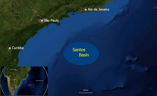
WThe Santos Basin is an approximately 352,000 square kilometres (136,000 sq mi) large mostly offshore sedimentary basin. It is located in the south Atlantic Ocean, some 300 kilometres (190 mi) southeast of Santos, Brazil. The basin is one of the Brazilian basins to have resulted from the break-up of Gondwana since the Early Cretaceous, where a sequence of rift basins formed on both sides of the South Atlantic; the Pelotas, Santos, Campos and Espírito Santo Basins in Brazil, and the Namibia, Kwanza and Congo Basins in southwestern Africa.
WBúzios oil field is a large ultra-deepwater oil field located in the Santos Basin, about 230 km (140 mi) off the coast of Rio de Janeiro, Brazil. Originally named Franco oil field, it was the second largest pre-salt find in the basin since 2007, behind Tupi oil field, which holds between 5 and 8 billion barrels equivalent and is located just south of the Búzios oil field.
 W
WThe Florianópolis Formation is a geological formation of the Santos Basin offshore of the Brazilian states of Rio de Janeiro, São Paulo, Paraná and Santa Catarina. The predominantly sandstone formation with interbedded shales and siltstones dates to the Early Cretaceous period; Albian epoch and has a thickness in the type oil well of 343 metres (1,125 ft).
WThe Guaratiba Group is a geological group of the Santos Basin offshore of the Brazilian states of Rio de Janeiro, São Paulo, Paraná and Santa Catarina. The group forms the pre-salt layer in the petroleum-rich basin and hosts the biggest oil fields of Brazil, as Tupi, Júpiter and many more. The group contains, depending on the definition, three to four formations and dates to the Early Cretaceous period; Hauterivian to Early Aptian epochs. The total thickness of the group, representing the first phase of sedimentation after the break-up of Gondwana in the Santos Basin, is estimated at 4,200 metres (13,800 ft).
WThe Guarujá Formation is a geological formation of the Santos Basin offshore of the Brazilian states of Rio de Janeiro, São Paulo, Paraná and Santa Catarina. The predominantly calcarenite formation with marls dates to the Early Cretaceous period; Early Albian epoch and has a maximum thickness of 2,500 metres (8,200 ft). The formation is the second-most important post-salt reservoir rock of the Santos Basin.
WIara oil field is a large ultra-deepwater pre-salt oil field located in the Santos Basin, 230 km (140 mi) off the coast of Rio de Janeiro, Brazil, north of Tupi oil field. It covers an area of nearly 300 km2 (120 sq mi).
WThe Iguape Formation is a geological formation of the Santos Basin offshore of the Brazilian states of Rio de Janeiro, São Paulo, Paraná and Santa Catarina. The calcarenite, shale, siltstone, marl and conglomerate formation dates to the Tertiary period and has a maximum thickness of 2,200 metres (7,200 ft).
WIracema is an oil field located in the Santos Basin, 250 km (160 mi) off the coast of Rio de Janeiro, Brazil, 33 km (21 mi) northwest of the giant Tupi oil field. Iracema is the third well drilled in the BM-S-11 block and could be an extension of ultra deep Tupi oil field. The field was previously called Cernambi.
WThe Itajaí-Açu Formation is a geological formation of the Santos Basin offshore of the Brazilian states of Rio de Janeiro, São Paulo, Paraná and Santa Catarina. The predominantly shale with interbedded turbiditic sandstones formation dates to the Late Cretaceous period; Cenomanian-Maastrichtian epochs and has a maximum thickness of 2,000 metres (6,600 ft). The formation is a reservoir rock of the fields in the Santos Basin.
WThe Itanhaém Formation is a geological formation of the Santos Basin offshore of the Brazilian states of Rio de Janeiro, São Paulo, Paraná and Santa Catarina. The predominantly shale formation with marls, siltstones and sandstones dates to the Early Cretaceous period; Early Albian epoch and has a maximum thickness of 1,500 metres (4,900 ft). The formation is the reservoir rock of the Tambaú Field in the Santos Basin.
WOn January 21, 2008, Petrobras announced the discovery of the Júpiter Field, a huge natural gas and condensate field which could equal the Tupi oil field in size. It is located in the Santos Basin, 37 km (23 mi) east of Tupi, 5,100 m (16,730 ft) below the bottom of the Atlantic Ocean in a water depth of 2,187 m (7,175 ft), 290 km (180 mi) from Rio de Janeiro.
WThe Juréia Formation is a geological formation of the Santos Basin offshore of the Brazilian states of Rio de Janeiro, São Paulo, Paraná and Santa Catarina. The predominantly shale with interbedded siltstones and fine sandstones formation dates to the Late Cretaceous period; Santonian-Maastrichtian epochs and has a maximum thickness of 2,000 metres (6,600 ft). The formation is a reservoir rock of the Merluza Field, the first discovery in the Santos Basin.
WLagosta Field is an oil and gas field located in the Santos Basin of southeastern Brazil. The field was discovered in July 2003 and was operated by El Paso Corp. oil company, holding a 60% stake with Petrobras owning the other 40%. Later, the field passed to Petrobras as operator. The field is estimated to contain 0.173 trillion cubic feet of gas, and 35.16 million barrels of oil in the Itajaí-Açu Formation. The field, located next to the Merluza Field, the first discovery in the Santos Basin in 1979, started development in 2009.
WThe Lapa oil field is a deepwater oil field in the pre-salt Guaratiba Group of the South Atlantic Santos Basin, 270 kilometres (170 mi) off the coast of São Paulo, Brazil. The field lies in water depths of approximately 2,140 metres (7,020 ft). When the discovery of the field was initially reported, it caused widespread commotion because of the speculated size of the field, which surpassed the Mexican Cantarell Complex, the biggest oil field complex outside of the Middle East. The size of Lapa, then known as Carioca and later as Sugar Loaf, was announced as possibly "as large as 33 billion barrels [5.2 billion cubic metres]". Later appraisal of the field drastically reduced the reserves to the current estimate of 459 million barrels.
WThe Marambaia Formation is a geological formation of the Santos Basin offshore of the Brazilian states of Rio de Janeiro, São Paulo, Paraná and Santa Catarina. The predominantly shale and marl formation dates to the Tertiary period and has a maximum thickness of 2,700 metres (8,900 ft). The formation is a seal and reservoir rock of the Atlanta and Oliva Fields in the Santos Basin.
 W
WPraia Grande crater is a 20 kilometres (12 mi) diameter circular feature in the Santos Basin offshore Brazil. It is a possible impact crater that has been identified on 3D seismic by Petrobras in 2004. Further investigation is needed to obtain more information on the structure. The Russian Academy of Sciences lists the structure as a probable impact crater.
WThe Santos Formation is a geological formation of the Santos Basin offshore of the Brazilian states of Rio de Janeiro, São Paulo, Paraná and Santa Catarina. The predominantly conglomeratic sandstone formation with interbedded shales dates to the Late Cretaceous period; Cenomanian-Maastrichtian epochs and has a maximum thickness of 2,700 metres (8,900 ft).
WThe Sapinhoá oil field is an oil field located in the southern Brazilian Santos Basin, 310 kilometres (190 mi) off the coast of Rio de Janeiro in a water depth of 7,065 feet (2,153 m). It was discovered in 2008 and originally named Guará field, under development by Petrobras. The oil field is operated by Petrobras and owned by Petrobras (45%) Repsol Sinopec Brazil (25%) and BG Group (30%). The total proven reserves of the Sapinhoá oil field range from 1,100–2,000 million barrels.
WThe Sepetiba Formation is a geological formation of the Santos Basin offshore of the Brazilian states of Rio de Janeiro, São Paulo, Paraná and Santa Catarina. The predominantly coquina formation dates to the Pleistocene period to recent and has a variable but maximum thickness of 570 metres (1,870 ft). The formation is the uppermost unit of the Santos Basin.