 W
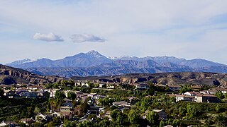
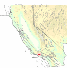
WThe Topatopa Mountains are a mountain range in Ventura County, California, north of Ojai, Santa Paula, and Fillmore. They are part of the Transverse Ranges of Southern California.
 W
WCalifornia's 24th congressional district is a congressional district in the U.S. state of California. The district is currently represented by Salud Carbajal. It contains all of Santa Barbara and San Luis Obispo counties and part of Ventura County.
 W
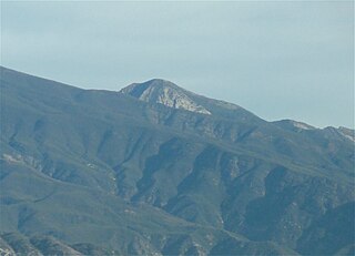
WCobblestone Mountain is a peak in the Topatopa Mountains, in Ventura County, several miles north of Piru, California. At 6,738 feet (2,054 m), it is the second highest peak of the Topatopa Mountains after Alamo mountain, and followed by Hines Peak. Snow frequently falls on the mountain during winter.
 W
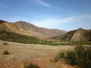
WCozy Dell Canyon is a canyon in the Topatopa Mountains immediately north of Meiners Oaks and three miles northwest of the Ojai Valley in central-western parts of Ventura County, California. It is located between Sheldon Canyon, Kennedy Canyon and McDonald Canyon, immediately east of the Ventura River. It is situated in the Los Padres National Forest and may be reached from numerous trailheads including the Cozy Dell Trail located in Ojala. It is the type locality for the Cozy Dell Shale and the name was first applied in 1928 by Kerr and Schenck. It is recognized for its natural beauty, creeks and creek beds, endemic wildflowers, diverse wildlife, rock formations, as well as panoramic views of surrounding mountains and the entire Ojai Valley.
 W
WThe Cozy Dell Shale is a geologic formation of middle Eocene age that crops out in the Santa Ynez Mountains and Topatopa Mountains of California, extending from north of Fillmore in Ventura County westward to near Point Arguello, north of Santa Barbara. Because the Cozy Dell easily weathers to a clay-rich soil, it crops out infrequently and generally forms dense stands of chaparral in saddles between peaks and ridges of the more resistant Matilija and Coldwater formations.
 W
WThe Day Fire was a devastating wildfire that burned 162,702 acres (658 km2) of land in the Topatopa Mountains, within the Los Padres National Forest in Ventura County, southern California. As of 2020, the Day Fire is the 20th largest wildfire in modern California history as of 09-09-2020.
 W
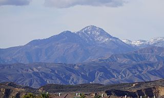
WHines Peak is the highest peak of the Topatopa Mountains, at 6,716 feet (2,047 m).
 W
WHopper Mountain National Wildlife Refuge is located in the Topatopa Mountains of Ventura County, in southern California. It is bordered by the Los Padres National Forest and the Sespe Condor Sanctuary to the north. The 2,471-acre (10.00 km2) refuge was established in 1974 to protect the endangered California condor, its habitat, and other wildlife resources.
 W
WLake Piru is a reservoir located in Los Padres National Forest and Topatopa Mountains of Ventura County, California, created by the construction in 1955 of the Santa Felicia Dam on Piru Creek, which is a tributary of the Santa Clara River.
 W
WOjai is a city in Ventura County in the U.S. state of California. Located in the Ojai Valley, it is northwest of Los Angeles and east of Santa Barbara. The valley is part of the east–west trending Western Transverse Ranges and is about 10 miles (16 km) long by 3 miles (5 km) wide and divided into a lower and an upper valley, each of similar size, surrounded by hills and mountains. The population was 7,461 at the 2010 census, down from 7,862 at the 2000 census.
 W
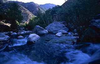
WPiru Creek is a major stream, about 71 miles (114 km) long, in northern Los Angeles County and eastern Ventura County, California. It is a tributary of the Santa Clara River, the largest stream system in Southern California that is still relatively natural.
 W
WRancho San Francisco was a land grant in present-day northwestern Los Angeles County and eastern Ventura County, California. It was a grant of 48,612 acres (19,673 ha) by Governor Juan B. Alvarado to Antonio del Valle, a Mexican army officer, in recognition for his service to Alta California. It is not related to the city of San Francisco.
 W
WThe San Cayetano Fault is an east-west trending thrust fault in Ventura County, Southern California. It stretches for 45 kilometers (28 mi), north of the city of Ventura, near the Topatopa Mountains, Piru, Fillmore, Santa Paula, Sulphur Springs, and Ojai.
 W
WThe Sespe Condor Sanctuary is a 53,000-acre (210 km2) wildlife refuge in the Topatopa Mountains, in northeastern Ventura County, California. It is within the Sespe Wilderness in the southern Los Padres National Forest.
 W
WSespe Creek is a stream, some 61 miles (98 km) long, in Ventura County, southern California, in the Western United States. The creek starts at Potrero Seco in the eastern Sierra Madre Mountains, and is formed by more than thirty tributary streams of the Sierra Madre and Topatopa Mountains, before it empties into the Santa Clara River in Fillmore.
 W
WThe Sespe Formation is a widespread fossiliferous sedimentary geologic unit in southern and south central California in the United States. It is of nonmarine origin, consisting predominantly of sandstones and conglomerates laid down in a riverine, shoreline, and floodplain environment between the upper Eocene Epoch through the lower Miocene. It is often distinctive in appearance, with its sandstones weathering to reddish-brown, maroon, pinkish-gray, tan, and green. Since many of its sandstones are more resistant to erosion than many other regional sedimentary units it often forms dramatic outcrops and ridgelines in many local mountain ranges.
 W
WThe Sespe Wilderness is a 219,700-acre (88,900 ha) wilderness area in the eastern Topatopa Mountains and southern Sierra Pelona Mountains, within the Los Padres National Forest (LPNF), in Ventura County, Southern California. The wilderness area is primarily located within the Ojai and Mt. Pinos ranger districts of the LPNF.
 W
WVal Verde is a census-designated place (CDP) in the southeastern Topatopa Mountains foothills, and in northwestern Los Angeles County, California. The city of Santa Clarita is to the east.
 W
WThe Ventura River, in western Ventura County in southern California, United States, flows 16.2 miles (26.1 km) from its headwaters to the Pacific Ocean. The smallest of the three major rivers in Ventura County, it flows through the steeply sloped, narrow Ventura Valley, with its final 0.7 miles (1.1 km) through the broader Ventura River estuary, which extends from where it crosses under a 101 Freeway bridge through to the Pacific Ocean.