 W
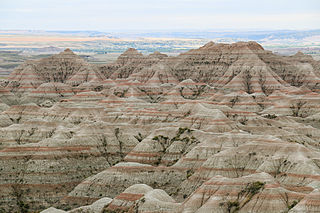
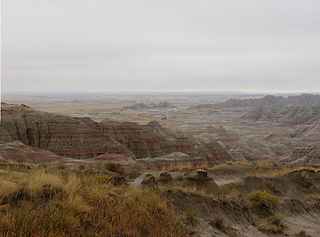
WBadlands National Park is an American national park located in southwestern South Dakota. The park protects 242,756 acres of sharply eroded buttes and pinnacles, along with the largest undisturbed mixed grass prairie in the United States. The National Park Service manages the park, with the South Unit being co-managed with the Oglala Lakota tribe.
 W
WThe Badlands Wilderness is located in the U.S. state of South Dakota. Entirely within Badlands National Park, the wilderness was designated by Congress in 1976, and is managed by the National Park Service. Badlands Wilderness, in southeastern Pennington County, includes 64,144 acres (560 km²) of the most pristine sections of the National Park. Within this wilderness, buffalo still roam free and visitors can also find bighorn sheep, coyotes and mule deer. There are no designated trails and camping is permitted anywhere in what is considered to be the largest undisturbed mixed-prairie rangeland remaining in the U.S. As this wilderness is managed by the National Park Service, hunting is not permitted.
 W
WBryce Canyon National Park is an American national park located in southwestern Utah. The major feature of the park is Bryce Canyon, which despite its name, is not a canyon, but a collection of giant natural amphitheaters along the eastern side of the Paunsaugunt Plateau. Bryce is distinctive due to geological structures called hoodoos, formed by frost weathering and stream erosion of the river and lake bed sedimentary rocks. The red, orange, and white colors of the rocks provide spectacular views for park visitors. Bryce Canyon National Park is much smaller, and sits at a much higher elevation than nearby Zion National Park. The rim at Bryce varies from 8,000 to 9,000 feet.
 W
WCanyonlands National Park is an American national park located in southeastern Utah near the town of Moab. The park preserves a colorful landscape eroded into numerous canyons, mesas, and buttes by the Colorado River, the Green River, and their respective tributaries. Legislation creating the park was signed into law by President Lyndon Johnson on September 12, 1964.
 W
WCapitol Reef National Park is an American national park in south-central Utah. The park is approximately 60 miles (97 km) long on its north–south axis and just 6 miles (9.7 km) wide on average. The park was established in 1971 to preserve 241,904 acres of desert landscape and is open all year, with May through September being the highest visitation months.
 W
WCedar Breaks National Monument is a U.S. National Monument located in the U.S. state of Utah near Cedar City. Cedar Breaks is a natural amphitheater, stretching across 3 miles (4.8 km), with a depth of over 2,000 feet (610 m). The elevation of the rim of the amphitheater is over 10,000 feet (3,000 m) above sea level.
 W
WDinosaur National Monument is an American national monument located on the southeast flank of the Uinta Mountains on the border between Colorado and Utah at the confluence of the Green and Yampa rivers. Although most of the monument area is in Moffat County, Colorado, the Dinosaur Quarry is located in Utah, north of the town of Jensen, Utah at 40°26′29″N 109°18′04″W. The nearest Colorado town is Dinosaur while the nearest city is Vernal, Utah.
 W
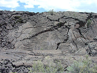
WThe El Malpais National Conservation Area is a federally protected conservation area in the U.S. state of New Mexico. The El Malpais National Conservation area was established in 1987 and is managed by the Bureau of Land Management as part of the National Landscape Conservation System. The adjoining El Malpais National Monument was established at the same time and is managed by the National Park Service.
 W
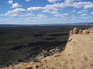
WEl Malpais National Monument is a National Monument located in western New Mexico, in the Southwestern United States. The name El Malpais is from the Spanish term Malpaís, meaning badlands, due to the extremely barren and dramatic volcanic field that covers much of the park's area.
 W
WThe Grand Staircase–Escalante National Monument (GSENM) is a United States national monument originally designated in 1996 as 1,880,461 acres (7,610 km2) of protected land in southern Utah. In 2017, the monument's size was reduced by half in a succeeding presidential proclamation. The land is among the most remote in the country; it was the last to be mapped in the contiguous United States.
 W
WHell's Half Acre is a large scarp located about 40 miles (64 km) west of Casper, Wyoming on US 20/26. Encompassing 320 acres (1.3 km2), this geologic oddity is composed of deep ravines, caves, rock formations and hard-packed eroded earth. Hell's Half Acre was used as the location for the fictional planet of Klendathu in the movie Starship Troopers.
 W
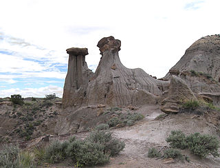
WMakoshika State Park is a nature preserve and public recreation area located on the southeast side of Glendive in Dawson County, Montana. The state park encompasses badlands containing dinosaur fossils and rock from the Hell Creek Formation. It is the largest of Montana's state parks at more than 11,000 acres (45 km²).
 W
WThe Oregon Badlands Wilderness is a 29,301-acre (11,858 ha) wilderness area located east of Bend in Deschutes and Crook counties in the U.S. state of Oregon. The wilderness is managed by the Bureau of Land Management as part of the National Landscape Conservation System and was created by the Omnibus Public Land Management Act of 2009, which was signed into law by President Barack Obama on 30 March 2009.
 W
WPetrified Forest National Park is an American national park in Navajo and Apache counties in northeastern Arizona. Named for its large deposits of petrified wood, the park covers about 346 square miles, encompassing semi-desert shrub steppe as well as highly eroded and colorful badlands. The park's headquarters is about 26 miles (42 km) east of Holbrook along Interstate 40 (I-40), which parallels the BNSF Railway's Southern Transcon, the Puerco River, and historic U.S. Route 66, all crossing the park roughly east–west. The site, the northern part of which extends into the Painted Desert, was declared a national monument in 1906 and a national park in 1962. The park received 644,922 recreational visitors in 2018.
 W
WThe Pine Ridge Indian Reservation, also called Pine Ridge Agency, is an Oglala Lakota Indian reservation located in the U.S. state of South Dakota. Originally included within the territory of the Great Sioux Reservation, Pine Ridge was created by the Act of March 2, 1889, 25 Stat. 888. in the southwest corner of South Dakota on the Nebraska border. Today it consists of 3,468.85 sq mi (8,984.3 km2) of land area and is one of the largest reservations in the United States.
 W
WPinnacles National Park is an American national park protecting a mountainous area located east of the Salinas Valley in Central California, about five miles (8.0 km) east of Soledad and 80 miles (130 km) southeast of San Jose. The park's namesakes are the eroded leftovers of the western half of an extinct volcano that has moved 200 miles (320 km) from its original location on the San Andreas Fault, embedded in a portion of the California Pacific Coast Ranges. Pinnacles is managed by the National Park Service and the majority of the park is protected as wilderness.
 W
WThe Red Rock Canyon National Conservation Area in Clark County, Nevada, is an area managed by the Bureau of Land Management as part of its National Landscape Conservation System, and protected as a National Conservation Area. It is about 15 miles (24 km) west of Las Vegas, and is easily seen from the Las Vegas Strip. More than three million people visit the area each year.
 W
WTheodore Roosevelt National Park is an American national park comprising three geographically separated areas of badlands in western North Dakota. The park was named for U.S. President Theodore Roosevelt. The park covers 70,446 acres of land in three sections: the North Unit, the South Unit, and the Elkhorn Ranch Unit.
WTheodore Roosevelt Wilderness is located in the U.S. state of North Dakota. Created by an act of Congress in 1978, the wilderness covers an area of 29,920 acres (121 km2) and comprises over a third of the entire area of Theodore Roosevelt National Park both of which are managed by the National Park Service. There are two geographically separated sections of wilderness, one in each of the units of the National Park. The northern section covers most of the North Unit of the park, in McKenzie County, whereas the somewhat smaller southern section covers only the western portion of the larger South Unit, in Billings County. The southern section is located at 46°59′N 103°33′W.
 W
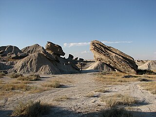
WToadstool Geologic Park is located in the Oglala National Grassland in far northwestern Nebraska. It is operated by the United States Forest Service. It contains a badlands landscape and a reconstructed sod house. The park is named after its unusual rock formations, many of which resemble toadstools.