 W
WIn Japan, an Earthquake Early Warning (EEW) is a warning issued when an earthquake is detected. The warnings are primarily issued by the Japan Meteorological Agency (JMA), with guidance on how to react to them.
 W
WEarthquake insurance is a form of property insurance that pays the policyholder in the event of an earthquake that causes damage to the property. Most ordinary homeowners insurance policies do not cover earthquake damage.
Earthquake Network is a research project that aims to develop and maintain a crowdsourced smartphone-based earthquake warning system at a global level. The system uses the on-board accelerometers in privately-owned smartphones of volunteer participants to detect earthquake waves. When it detects an earthquake, it issues an earthquake warning to alert people who the damaging waves of the earthquake have not yet reached.
 W
WEarthquake scenario is a planning tool to determine the appropriate emergency responses or building systems in areas exposed to earthquake hazards. It uses the basics of seismic hazard studies, but usually places a set earthquake on a specific fault, most likely near a high-population area. Most scenarios relate directly to urban seismic risk, and seismic risk in general.
 W
WAn earthquake warning system or earthquake early warning system is a system of accelerometers, seismometers, communication, computers, and alarms that is devised for notifying adjoining regions of a substantial earthquake while it is in progress. This is not the same as earthquake prediction, which is currently incapable of producing decisive event warnings.
 W
WThe George Massey Tunnel is a highway traffic tunnel in the Metro Vancouver region of southwestern British Columbia. It is located approximately 20 km (12.4 mi) south of the city centre of Vancouver, British Columbia, and approximately 30 km (18.6 mi) north of the Canada–United States border at Blaine, Washington.
 W
WICEARRAY is an abbreviation for Icelandic Strong-motion Array. The ICEARRAY network is a seismic array of 14 strong-motion stations located within the South Iceland Seismic Zone. Each station consists of a seismograph situated in a protective housing. The stations are spread across a geographical area of approximately 3 km² in the town of Hveragerdi in south-western Iceland. Most of the units are located in the basements of residential buildings in Hveragerdi town centre, which is approximately 35 km southeast of Iceland's capital, Reykjavík. The ICEARRAY project is supported by the 6th Framework of the European Commission through the Marie Curie International Re-integration Grant, the Iceland Centre for Research and the University of Iceland Earthquake Engineering Research Centre.
 W
WThe Mexican Seismic Alert System is the earthquake warning system covering portions of central and southern Mexico. It currently provides up to 60 seconds' warning of earthquakes to Mexico City, Acapulco, Chilpancingo, Morelia, Puebla City, Oaxaca City, Guadalajara, Colima and Toluca. SASMEX is administered by a non-profit civil association, Center for Seismic Instrumentation and Registry . The SASMEX sensor network serving Mexico City has been regarded as the first earthquake early warning system issuing alerts available to the public. SASMEX supplies regular information of all kinds, including reports of earthquakes of all magnitudes, and drills, via Twitter, under the name AlertaSísmica SASMEX. All earthquakes are reported as #TenemosSismo ; warnings of serious ones are delivered as #AlertaSismica.
 W
WThe Pacific Tsunami Warning Center (PTWC) is one of two tsunami warning centers that are operated by NOAA in the United States. Headquartered on Ford Island, HI, the PTWC is part of an international tsunami warning system (TWS) program and serves as the operational center for TWS of the Pacific issuing bulletins and warnings to participating members and other nations in the Pacific Ocean area of responsibility. It is also the regional (local) warning center for the State of Hawaii. The other tsunami warning center is the National Tsunami Warning Center (NTWC) in Palmer, Alaska, serving all coastal regions of Canada and the United States except Hawaii, the Caribbean Sea and the Gulf of Mexico.
 W
WSeismic analysis is a subset of structural analysis and is the calculation of the response of a building structure to earthquakes. It is part of the process of structural design, earthquake engineering or structural assessment and retrofit in regions where earthquakes are prevalent.
 W
WA seismic hazard is the probability that an earthquake will occur in a given geographic area, within a given window of time, and with ground motion intensity exceeding a given threshold. With a hazard thus estimated, risk can be assessed and included in such areas as building codes for standard buildings, designing larger buildings and infrastructure projects, land use planning and determining insurance rates. The seismic hazard studies also may generate two standard measures of anticipated ground motion, both confusingly abbreviated MCE; the simpler probabilistic Maximum Considered Earthquake, used in standard building codes, and the more detailed and deterministic Maximum Credible Earthquake incorporated in the design of larger buildings and civil infrastructure like dams or bridges. It is important to clarify which MCE is being discussed.
 W
WSeismic microzonation is defined as the process of subdividing a potential seismic or earthquake prone area into zones with respect to some geological and geophysical characteristics of the sites such as ground shaking, liquefaction susceptibility, landslide and rock fall hazard, earthquake-related flooding, so that seismic hazards at different locations within the area can correctly be identified. Microzonation provides the basis for site-specific risk analysis, which can assist in the mitigation of earthquake damage. In most general terms, seismic microzonation is the process of estimating the response of soil layers under earthquake excitations and thus the variation of earthquake characteristics on the ground surface.
 W
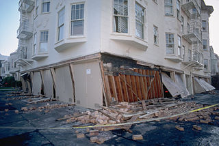
WSeismic retrofitting is the modification of existing structures to make them more resistant to seismic activity, ground motion, or soil failure due to earthquakes. With better understanding of seismic demand on structures and with our recent experiences with large earthquakes near urban centers, the need of seismic retrofitting is well acknowledged. Prior to the introduction of modern seismic codes in the late 1960s for developed countries and late 1970s for many other parts of the world, many structures were designed without adequate detailing and reinforcement for seismic protection. In view of the imminent problem, various research work has been carried out. State-of-the-art technical guidelines for seismic assessment, retrofit and rehabilitation have been published around the world – such as the ASCE-SEI 41 and the New Zealand Society for Earthquake Engineering (NZSEE)'s guidelines. These codes must be regularly updated; the 1994 Northridge earthquake brought to light the brittleness of welded steel frames, for example.
 W
WShakeAlert is an earthquake early warning system (EEW) for the West Coast of the United States and the Pacific Northwest sponsored by the United States Geological Survey (USGS).
 W
WA soft story building is a multi-story building in which one or more floors have windows, wide doors, large unobstructed commercial spaces, or other openings in places where a shear wall would normally be required for stability as a matter of earthquake engineering design. A typical soft story building is an apartment building of three or more stories located over a ground level with large openings, such as a parking garage or series of retail businesses with large windows.
 W
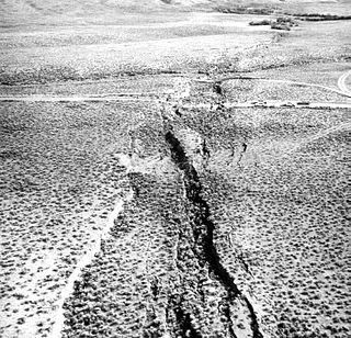
WSurface rupture is the visible offset of the ground surface when an earthquake rupture along a fault affects the Earth's surface. Surface rupture is opposed by buried rupture, where there is no displacement at ground level. This is a major risk to any structure that is built across a fault zone that may be active, in addition to any risk from ground shaking. Surface rupture entails vertical or horizontal movement, on either side of a ruptured fault. Surface rupture can affect large areas of land.
 W
WThe Triangle of Life is an unsubstantiated theory about how to survive a major earthquake, typically promoted via viral emails. The theory advocates methods of protection very different from the mainstream advice of "drop, cover, and hold on" method widely supported by reputable agencies. In particular, the method's developer and key proponent, Doug Copp, recommends that at the onset of a major earthquake, building occupants should seek shelter near solid items that will provide a protective space, a void or space that could prevent injury or permit survival in the event of a major structural failure, a "pancake collapse", and specifically advises against sheltering under tables.
 W
WThe 2015 Uniform California Earthquake Rupture Forecast, Version 3, or UCERF3, is the latest official earthquake rupture forecast (ERF) for the state of California, superseding UCERF2. It provides authoritative estimates of the likelihood and severity of potentially damaging earthquake ruptures in the long- and near-term. Combining this with ground motion models produces estimates of the severity of ground shaking that can be expected during a given period, and of the threat to the built environment. This information is used to inform engineering design and building codes, planning for disaster, and evaluating whether earthquake insurance premiums are sufficient for the prospective losses. A variety of hazard metrics can be calculated with UCERF3; a typical metric is the likelihood of a magnitude M 6.7 earthquake in the 30 years since 2014.
 W
WUrban seismic risk is a subset of the general term seismic risk which describes the problems specific to centers of population when they are subjected to earthquakes. Many risks can be minimized with good earthquake construction, and seismic analysis. One of the best ways to deal with the issue is through an earthquake scenario analysis.
 W
WVertical and horizontal evacuation are strategies for providing safety to humans in case of tsunami, hurricane or other natural disaster.