 W
WAlfeiós is the longest river in the Peloponnese, in Greece. The river is 110 kilometres (68 mi) long, flowing through the regional units of Arcadia and Elis. Its source is near the village Dorizas, about halfway between Tripoli and Megalopoli in the highlands of Arcadia. It flows southwest toward Megalopoli, where it has been diverted around open pit lignite mines. At Thoknia it receives its right tributary Elissonas, and continues north towards Karytaina. Below Karytaina the Lousios flows into the Alfeios, and the Alfeios continues northwest, passing north of Andritsaina. Near Tripotamia the rivers Ladon and Erymanthos flow into the Alfeios. The Alfeios then flows west along Olympia and empties into the Ionian Sea south of Pyrgos.
 W
WThe Argolic Gulf, also known as the Gulf of Argolis or Gulf of Nafplio, is a gulf of the Aegean Sea off the east coast of the Peloponnese, Greece. It is about 50 km long and 30 km wide. Its main port is Nafplio, at its northwestern end. At the entrance to the gulf is the island Spetses. This gulf and its islands are sometimes combined with the Saronic Gulf and Saronic Islands, with the result called the Argo-Saronic Gulf and the Argo-Saronic Islands. It is surrounded by two regional units: Arcadia to the southwest and Argolis to the north and east. The river Inachos drains into the Argolic Gulf near Nea Kios. The main islands in the gulf are Psili, Plateia and Bourtzi, a small island with a Venetian fortress that protects the port of Nafplio. The surrounding mountains protect it from the strong summer Meltemi wind.
 W
WErymanthos is a river in the western part of the Peloponnese in Greece. Its source is on the southern slope of the Mount Erymanthos, near the village Agrampela, Achaea. It flows towards the south through a rocky landscape and receives several small tributaries. The river flows into an area rich in pine trees and passes several small mountain villages including Tripotama. Beyond Tripotama it forms the border between Elis and Arcadia. It flows east of the Foloi oak forest. The river empties into the Alfeios 5 km west of the Ladon (river) confluence, near the village Tripotamia.
 W
WThe Ladon is a river in the Peloponnese peninsula of Greece. It features in Greek mythology. It is a tributary to the river Alfeios, which empties into the Ionian Sea. It is 70 km (43 mi) long.
 W
WThe Ladon Lake or the Ladon Reservoir is an artificial lake in the upper part of the river Ladon, in the northwestern part of Arcadia, Greece. The 50 m high dam was built in 1955. The reservoir is situated in a sparsely populated, mountainous area. It is completely in the municipality Gortynia, municipal units Kleitor, Kontovazaina and Tropaia.
 W
WThe Lepida Gorge is a natural formation of Mount Parnon, located in the region of Arcadia, Peloponnese. Despite its length is only 500 metres, it has a relatively big waterfall of 70 meters height and a smaller one of 45 meters.
 W
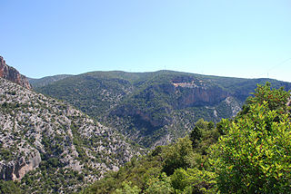
WThe Lousios, also known in antiquity as Gortynius or Gortynios, is a river and a gorge in western Arcadia that stretches from Karytaina north to Dimitsana in Greece. The river begins near Lykochori and flows through the Lousios Gorge. The river is treacherous and flows rapidly. It empties into the Alfeios 2.5 kilometres (1.6 mi) northwest of Karytaina and south of Atsicholos.
 W
WMainalo is the tallest mountain in the Menalon highlands of the Peloponnese, and is located in Arcadia, Greece. In antiquity, the mountain was especially sacred to Pan.
 W
WMount Lykaion is a mountain in Arcadia, Greece. Lykaion has two peaks: Stefani to the north and St. Ilias to the south where the altar of Zeus is located.
 W
WMoustos is a wetland located a few kilometers from Astros. It divides the Thyreatis plain into two parts, the plain of Astros and the plain of Agios Andreas.
WNestani is a village and a community in the municipal unit Mantineia, Arcadia, Greece.
 W
WOligyrtos is a mountain located at the junction of Arcadia, Corinthia and Argolis in the northeastern Peloponnese in Greece. The mountain diagonally stretches from southwest to northeast, with about 35 km length and 15 to 20 km breadth. Its highest point is the peak Skipiza, at1,935 m elevation. Other peaks are Gkrimini, Parnias, Skiathis and Mavrovouni. Neighboring mountain ranges are Kyllini (Ziria) to the north, Mainalo to the southwest, Trachy to the south and Chelmos (Aroania) to the northwest. Local flora consists mostly of grasslands and bushes. Pine trees and barren lands are found in higher areas. It is drained towards the Lake Stymphalia to the north, and towards the plain of Kandila to the south. In antiquity, the fortress Oligyrtus was located in a pass on the mountain.
 W
WParnon or Parnonas or Malevos (Μαλεβός) is a mountain range, or massif, on the east of the Laconian plain and the Evrotas valley. It is visible from Athens above the top of the Argive mountains. The western part is in the Laconia prefecture and the northeastern part is in the Arcadia prefecture. The Parnon range separates Laconia from Arcadia. Its summit offers panoramic views of southeastern Arcadia and South Kynouria and much of Laconia that includes the northern and the central portions and reaches as far as the Taygetos mountains. It also views a part of the central Arcadia and the southern Argolis prefectures. It views the Myrtoan and the Laconian Gulfs.
 W
WMount Parthenion or Parthenius or Parthenium) is a mountain on the border of Arcadia and Argolis, in the Peloponnese, Greece. Its elevation is 1,215 m. It is situated between the villages Achladokampos to the northeast and Partheni to the southwest. It is 16 km east of Tripoli.
 W
WLake Taka is a temporary lake located in the south of a large basin called “Tripoli-Plateau” in Greece. In the winter, the southern part of the basin often gets flooded, and a lake forms from a large amount of fresh rainwater because of insufficient surface drainage. A wetland biotope quickly develops, and species of water-loving fauna appear. In the hot and dry summer, the lake dries up. Over time, karstification creates several ponors, where water leaves the basin through groundwater.
 W
WThe Taygetus, Taugetus, Taygetos or Taÿgetus is a mountain range on the Peloponnese peninsula in Southern Greece. The highest mountain of the range is Mount Taygetus, also known as "Profitis Ilias", or "Prophet Elias". The name is one of the oldest recorded in Europe, appearing in the Odyssey. In classical mythology, it was associated with the nymph Taygete. During Byzantine times and up until the 19th century, the mountain was also known as Pentadaktylos.
WThe Tsemperou is a mountain located in southern Arcadia, central Peloponnese, Greece. The elevation of its summit is 1,254 m. It is situated southeast of the plain of Megalopoli, 12 km from the town centre. Villages on the Tsemperou include Anavryto and Paparis. The river Alfeios flows north of the mountain.
 W
WVlacherna is a settlement in Arcadia, Greece. Administratively it is the seat of the local community. It is a municipal unit of Levidi in the municipality of Tripoli. It is built at a height of 954 meters above sea level, on the slopes of Mainalo. It is 32 kilometers from Tripoli, 7 km from Levidi and 12 km from Vytina.
 W
WThe Vouraikos is a river in Achaea, Greece. In ancient times it was called Erasinos. Its source is in the Aroania mountains, near the village of Priolithos. It flows past the towns of Kalavryta and Diakopto, and flows into the Gulf of Corinth near Diakopto. It is 37.5 km (23.3 mi) long. The name is derived from Boura, a mythological daughter of Ion and Helice who was beloved by Hercules, who according to legend opened the gorge in order to get close to her. This is the Vouraikos gorge, which has a length of about 20 km. In the gorge the river passes along dense vegetation and steep cliffs, waterfalls and caves. The Diakofto–Kalavryta Railway passes through the Vouraikos gorge.
 W
WZavitsa is a mountain in the Peloponnese, known in antiquity as Timenion Oros, meaning Timenion mountain. Its contemporary name comes from the slavic word "zavičaj" which means "homeland". It lies on the northeastern edges of Arcadia, marking the natural boundaries with Argolis to the north. Its highest peak is Profitis Ilias rising at 974 meters above sea level. Its easternmost slopes reach the Arcadian coasts that form part of the wider Argolic Gulf area. Xiropigado, Kato Vervena, Kato Doliana and Prosilia are villages located around its slopes.