 W
WThe Baie de Seine is a bay in northern France.
 W
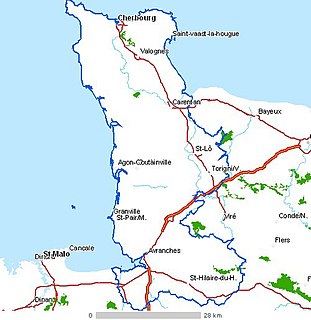
WCap de la Hague is a cape at the tip of the Cotentin peninsula in Normandy, France.
 W
WChausey is a group of small islands, islets and rocks off the coast of Normandy, in the English Channel. It lies 17 kilometres (11 mi) from Granville and forms a quartier of the Granville commune in the Manche département. Chausey forms part of the Channel Islands from a geographical point of view, but, because it is under French jurisdiction, it is almost never mentioned in the context of the other Channel Islands. There are no scheduled transport links between Chausey and the other Channel Islands, although between two and four daily shuttles link Chausey to mainland France through Granville, depending on the season.
 W
WThe Côte d'Albâtre is part of the French coast of the English Channel, corresponding to the coastline of Pays de Caux and forming almost all of the coastline of Seine-Maritime. Since 2009 it has been classified as a Natura 2000 site. It takes its name from the white hue of its high chalk cliffs, including those of Étretat, which stretch for over 120 km, dominating most of the coastline. It is part of the same geological system as the White Cliffs of Dover on the far side of the English Channel.
 W
WThe Côte Fleurie stretches for approximately 40 km (25 mi) between Merville-Franceville-Plage, at the mouth of the Orne river, opposite Ouistreham to the west and Honfleur on the Seine estuary in the east. It forms part of the eastern Basse-Normandie coast on the English Channel to the north of the Pays d'Auge in the Calvados department. The coast between the towns of Trouville and Honfleur, although part of the Côte Fleurie, is named Côte de Grace. Dives-sur-Mer is on the Côte Fleurie but possesses no beach or seafront. The Côte de Nacre continues west from the Touques estuary.
 W
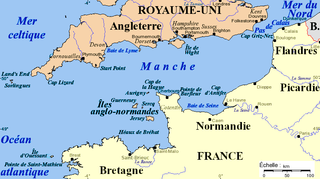
WThe Cotentin Peninsula, also known as the Cherbourg Peninsula, is a peninsula in Normandy that forms part of the northwest coast of France. It extends north-westward into the English Channel, towards Great Britain. To its west lie the Channel Islands and to the southwest lies the peninsula of Brittany.
 W
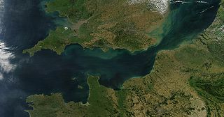
WThe English Channel, also called simply the Channel, is an arm of the Atlantic Ocean that separates Southern England from northern France and links to the southern part of the North Sea by the Strait of Dover at its northeastern end. It is the busiest shipping area in the world.
 W
WÉtretat is a commune in the Seine-Maritime department in Normandy in north-western France. It is a tourist and farming town situated about 32 km (20 mi) north-east of Le Havre, at the junction of the D 940, D 11 and D 139 roads. It is located on the coast of the Pays de Caux area.
 W
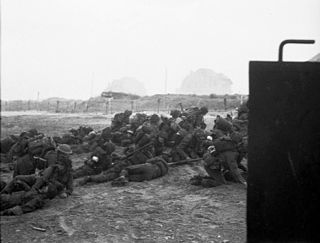
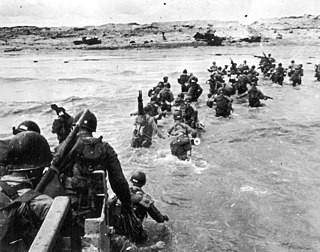
WGold, commonly known as Gold Beach, was the code name for one of the five areas of the Allied invasion of German-occupied France in the Normandy landings on 6 June 1944, during the Second World War. Gold, the central of the five areas, was located between Port-en-Bessin on the west and La Rivière on the east. High cliffs at the western end of the zone meant that the landings took place on the flat section between Le Hamel and La Rivière, in the sectors code-named Jig and King. Taking Gold was to be the responsibility of the British Army, with sea transport, mine sweeping, and a naval bombardment force provided by the Royal Navy as well as elements from the Dutch, Polish and other Allied navies.
 W
WGrande-Île is the largest of the islands of Chausey located near the Channel Islands off the coast of Normandy in France. The island is 1.5 kilometres (0.93 mi) long and 0.5 kilometres (0.31 mi) wide at its widest being approximately 45 hectares in area. It has a population of 30. The main part of the grounds of the main island and the small islands belong to the Société Civile Immobiliére des Iles Chausey, created at the beginning of the 20th century.
 W
WJuno or Juno Beach was one of five beaches of the Allied invasion of German-occupied France in the Normandy landings on 6 June 1944 during the Second World War. The beach spanned from Courseulles, a village just east of the British beach Gold, to Saint-Aubin-sur-Mer, and just west of the British beach Sword. Taking Juno was the responsibility of the Canadian Army, with sea transport, mine sweeping, and a naval bombardment force provided by the Royal Canadian Navy and the British Royal Navy as well as elements from the Free French, Norwegian, and other Allied navies. The objectives of the 3rd Canadian Infantry Division on D-Day were to cut the Caen-Bayeux road, seize the Carpiquet airport west of Caen, and form a link between the two British beaches on either flank.
 W
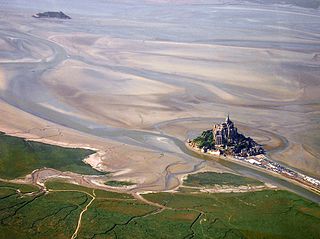
WThe Mont-Saint-Michel Bay is located between Brittany and the Normandy peninsula of Cotentin. The bay is part of the club of the world's most beautiful bays (fr) and is listed as a UNESCO world heritage site. Due to the significant tidal movements in this region a large part of the bay is uncovered at low tide. There are two granitic islands in the bay: Tombelaine and the Mont-Saint-Michel. Many birds and harbor seal live in this area.
 W
WLe Mont-Saint-Michel is a tidal island and mainland commune in Normandy, France.
 W
WOmaha, commonly known as Omaha Beach, was the code name for one of the five sectors of the Allied invasion of German-occupied France in the Normandy landings on June 6, 1944, during World War II. "Omaha" refers to an 8-kilometer (5 mi) section of the coast of Normandy, France, facing the English Channel, from east of Sainte-Honorine-des-Pertes to west of Vierville-sur-Mer on the right bank of the Douve River estuary. Landings here were necessary to link the British landings to the east at Gold with the American landing to the west at Utah, thus providing a continuous lodgement on the Normandy coast of the Bay of the Seine. Taking Omaha was to be the responsibility of United States Army troops, with sea transport, mine sweeping, and a naval bombardment force provided predominantly by the United States Navy and Coast Guard, with contributions from the British, Canadian and Free French navies.
 W
WPhare de Gatteville, also known as Pointe de Barfleur Light, is an active lighthouse near Gatteville-le-Phare at the tip of Barfleur, Manche department, in the Lower Normandy region of France. At a height of 247 feet (75 m) it is the third tallest "traditional lighthouse" in the world.
 W
WThe Roumois is a region in the northwestern part of the Eure département in Normandy, France. It is a plateau situated southwest of Rouen. Its northern boundary is the Seine downstream of Elbeuf, its western boundary is the Risle valley. The plain of Le Neubourg lies to the south. The main towns of the Roumois are Bourg-Achard and Bourgtheroulde-Infreville. The landscape is similar to that of the Pays de Caux on the north side of the Seine.
 W
WSword, commonly known as Sword Beach, was the code name given to one of the five main landing areas along the Normandy coast during the initial assault phase, Operation Neptune, of Operation Overlord, the Allied invasion of German-occupied France that commenced on 6 June 1944. Stretching 8 kilometres (5.0 mi) from Ouistreham to Saint-Aubin-sur-Mer, the beach proved to be the easternmost landing site of the invasion after the abortion of an attack on a sixth beach, code-named Band. Taking Sword was to be the responsibility of the British Army with sea transport, mine sweeping, and a naval bombardment force provided by the British Royal Navy as well as elements from the Polish, Norwegian and other Allied navies.
 W
WUtah, commonly known as Utah Beach, was the code name for one of the five sectors of the Allied invasion of German-occupied France in the Normandy landings on June 6, 1944 (D-Day), during World War II. The westernmost of the five code-named landing beaches in Normandy, Utah is on the Cotentin Peninsula, west of the mouths of the Douve and Vire rivers. Amphibious landings at Utah were undertaken by United States Army troops, with sea transport, mine sweeping, and a naval bombardment force provided by the United States Navy and Coast Guard as well as elements from the British, Dutch and other Allied navies.
 W
WThe Val de Saire is an area situated in the north of the Cotentin Peninsula, to the east of Cherbourg in the French region of Lower Normandy. To the south lies the Plain. It is named after the river Saire, which flows from Mesnil-au-Val into the English Channel between Réville and Saint-Vaast-la-Hougue.
 W
WIn the Pays de Caux, Normandy, France a valleuse is a depression in the land surface of the plateau which permits access to the sea. On the rest of this coast, that access is prevented by the height of the chalk cliffs.