 W
WThe Andaman Sea is a marginal sea of northeastern Indian Ocean bounded by the coastlines of Myanmar and Thailand along the Gulf of Martaban and west side of the Malay Peninsula, and separated from the Bay of Bengal to its west by the Andaman Islands and the Nicobar Islands. Its southernmost end is defined by Breueh Island, an island just north of Sumatra, and communicates with the Malacca Strait.
 W
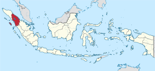
WAceh is the westernmost province of Indonesia. It is located on the northern end of Sumatra, with Banda Aceh being its capital and largest city. Granted a special autonomous status, Aceh is a religiously conservative territory and the only Indonesian province practicing Sharia law officially. There are ten indigenous ethnic groups in this region, the largest being the Acehnese people, accounting for approximately 80% to 90% of the region's population.
 W
WThe Andaman and Nicobar Islands, a union territory of India comprising 572 islands of which 37 are inhabited, are a group of islands at the juncture of the Bay of Bengal and the Andaman Sea.
 W
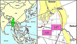
WThe Gulf of Martaban or the Gulf of Mottama is an arm of the Andaman Sea in the southern part of Burma. The gulf is named after the port city of Mottama. The Sittaung, Salween and Yangon rivers empty into it.
 W
WKedah, also known by its honorific Darul Aman or "Abode of Peace" is a state of Malaysia, located in the northwestern part of Peninsular Malaysia. The state covers a total area of over 9,000 km², and it consists of the mainland and the Langkawi islands. The mainland has a relatively flat terrain, which is used to grow rice, while Langkawi is an archipelago, most of which are uninhabited islands.
 W
WThe Kra Isthmus in Thailand is the narrowest part of the Malay Peninsula. The western part of the isthmus belongs to Ranong Province and the eastern part to Chumphon Province, both in Southern Thailand. The isthmus is bordered to the west by the Andaman Sea and to the east by the Gulf of Thailand.
 W
WThe Kraburi River, also Kra or Pak Chan River is the boundary river between Thailand and Myanmar at the Kra Isthmus of the Malay Peninsula. The river has its source in the Tenasserim Hills and flows into the Andaman Sea near the Thai town of Ranong and Kawthaung, Myanmar.
 W
WThe Malay Peninsula is a peninsula in Southeast Asia. The land mass runs approximately north–south and, at its terminus, is the southernmost point of the Asian mainland. The area contains Peninsular Malaysia, Southern Thailand, and the southernmost tip of Myanmar (Kawthaung), as well as the city state of Singapore, indigenous to or historically inhabited by the Malays, an Austronesian people.
 W
WMon State is an administrative division of Myanmar. It lies between Kayin State to the east, the Andaman Sea to the west, Bago Region to the north and Tanintharyi Region to the south, also having a short border with Thailand's Kanchanaburi Province at its south-eastern tip. The land area is 12,155 km2 (4,693 sq mi). The Dawna Range, running along the eastern side of the state in a NNW–SSE direction, forms a natural border with Kayin State. Mon State includes some small islands, such as Kalegauk, Wa Kyun and Kyungyi Island, along its 566 km (352 mi) of coastline. The state's capital is Mawlamyine.
 W
WNorth Sumatra is a province of Indonesia. It consists of a large northwestern belt of the island of Sumatra and its capital is Medan. North Sumatra is the fourth most-populous province after West Java, East Java and Central Java — it covers an area of 72,981 km2, and at the Census of 2015 it had a population of 13,923,262; the latest official estimate as at mid 2019 is 14,639,400.
 W
WThe Penang Strait is an 11 kilometre-wide strait that separates Penang Island from mainland Malay Peninsula. Penang Island is to the west of the channel, while Seberang Perai, the mainland half of the State of Penang, is to the east. The northern and southern ends of the channel join the Strait of Malacca, one of the world's busiest maritime routes.
 W
WPerlis, also known by its honorific title Perlis Indera Kayangan, is the smallest state in Malaysia. It lies at the northern part of the west coast of Peninsular Malaysia and has the Satun and Songkhla Provinces of Thailand on its northern border. It is bordered by the state of Kedah to the south. It was called Palit by the Siamese when it was under their influence. Perlis had a population of 227,025 as of 2010.
 W
WPhang Nga is one of the southern provinces (changwat) of Thailand, on the shore of the Andaman Sea to the west and Phang Nga Bay to the south. Neighboring provinces are Ranong, Surat Thani, and Krabi. To the south is the Phuket Province, connected by the Sarasin Bridge.
 W
WPhuket is one of the southern provinces (changwat) of Thailand. It consists of the island of Phuket, the country's largest island, and another 32 smaller islands off its coast. It lies off the west coast of Thailand in the Andaman Sea. Phuket Island is connected by the Sarasin Bridge to Phang Nga Province to the north. The next nearest province is Krabi, to the east across Phang Nga Bay.
 W
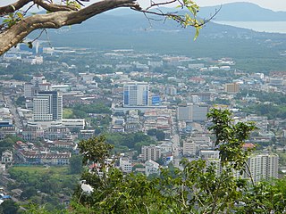
WPhuket is a city in the southeast of Phuket island, Thailand. It is the capital of Phuket Province. As of 2007 the city had a population of 75,573. It covers the subdistricts (tambons) Talat Yai and Talat Nuea of Mueang Phuket District.
 W
WRanong is one of Thailand's southern provinces (changwat), on the west coast along the Andaman Sea. It has the fewest inhabitants of all Thai provinces. Provinces neighboring Ranong are (clockwise) Chumphon, Surat Thani, and Phang Nga. To the west, it borders Kawthaung, Tanintharyi, Myanmar.
 W
WRichelieu Rock is a dive site in Thailand in the Andaman Sea about 200 km northwest of Phuket. It is part of the Mu Koh Surin marine park although being about 18 km east of Surin Island.
 W
WRitchie's Archipelago is a cluster of smaller islands which lie 20 km (12 mi) east of Great Andaman, the main island group of the Andaman Islands. The Islands belong to the South Andaman administrative district, part of the Indian union territory of Andaman and Nicobar Islands.
 W
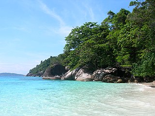
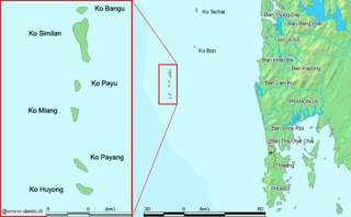
WThe Similan Islands is an archipelago in the Andaman Sea off the coast of, and part of, Phang Nga Province in southern Thailand. It was established as Mu Ko Similan National Park in 1982 after a one-year assessment by the forestry department.
 W
WThe Strait of Malacca or Straits of Malacca is a narrow stretch of water, 580 mi (930 km) in length, between the Malay Peninsula and the Indonesian island of Sumatra. As the main shipping channel between the Indian Ocean and the Pacific Ocean, it is one of the most important shipping lanes in the world. It is named after the Malacca Sultanate that ruled over the archipelago between 1400 and 1511, the center of administration of which was located in the modern-day state of Malacca, Malaysia.
 W
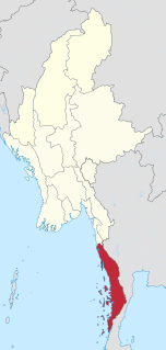
WTanintharyi Region is an administrative region of Myanmar, covering the long narrow southern part of the country on the Kra Isthmus. It borders the Andaman Sea to the west and the Tenasserim Hills, beyond which lie Thailand, to the east. To the north is the Mon State. There are many islands off the coast, the large Mergui Archipelago in the southern and central coastal areas and the smaller Moscos Islands off the northern shores. The capital of the division is Dawei (Tavoy). Other important cities include Myeik (Mergui) and Kawthaung. The division covers an area of 43,344.9 km², and had a population of 1,406,434 at the 2014 Census.