 W
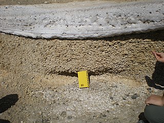
WTuff is a type of rock made of volcanic ash ejected from a vent during a volcanic eruption. Following ejection and deposition, the ash is lithified into a solid rock. Rock that contains greater than 75% ash is considered tuff, while rock containing 25% to 75% ash is described as tuffaceous.
 W
WPhreatomagmatic eruptions are volcanic eruptions resulting from interaction between magma and water. They differ from exclusively magmatic eruptions and phreatic eruptions. Unlike phreatic eruptions, the products of phreatomagmatic eruptions contain juvenile (magmatic) clasts. It is common for a large explosive eruption to have magmatic and phreatomagmatic components.
 W
WThe Aleipata Islands is a group of four uninhabited islands off the eastern end of Upolu Island, Samoa, with an aggregate area of 1.68 km2):Nu'utele (1.08 km2) Nu'ulua (0.25 km2) Namua (0.20 km2) Fanuatapu (0.15 km2)
 W
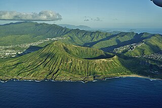
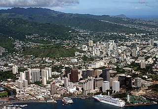
WDiamond Head is a volcanic tuff cone on the Hawaiian island of Oʻahu and known to Hawaiians as Lēʻahi. The Hawaiian name is most likely derived from lae plus ʻahi (tuna) because the shape of the ridgeline resembles the shape of a tuna's dorsal fin. Its English name was given by British sailors in the 19th century, who mistook calcite crystals on the adjacent beach for diamonds.
WFanuatapu is an uninhabited island which consists of a volcanic tuff ring, situated off the eastern tip of Upolu, Samoa. It is the smallest and easternmost of the four Aleipata Islands, with an area of 15 hectares, and has an automated lighthouse.
 W
WFort Rock is a tuff ring located on an ice age lake bed in north Lake County, Oregon, United States. The ring is about 4,460 feet (1,360 m) in diameter and stands about 200 feet (60 m) high above the surrounding plain. Its name is derived from the tall, straight sides that resemble the palisades of a fort. The region of Fort Rock-Christmas Lake Valley Basin contains about 40 such tuff rings and maars and is located in the Brothers Fault Zone of central Oregon's Great Basin. William Sullivan, an early settler in the area, named Fort Rock in 1873 while searching for lost cattle.
 W
WKahauloa Crater is a tuff cone located in Hawaii. It sits between Koko Crater and Hanauma Bay. The Koko Head Shooting Complex operates in its crater.
WKaʻau Crater is an extinct volcanic crater located in the U.S. state of Hawaii near Palolo Valley.
 W
WKaʻula Island, also called Kaʻula Rock, is a small, crescent-shaped offshore islet in the Hawaiian Islands.
 W
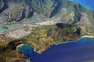
WKoko Crater is an extinct tuff cone located on the Hawaiian island of Oahu near Hawaii Kai. It is northeast of Hanauma Bay and south of the Koʻolau Range.
 W
WKoko Head is the headland that defines the eastern side of Maunalua Bay along the southeastern side of the Island of Oahu in Hawaii. On its western slope is the community of Portlock, a part of Hawaiʻi Kai. Koko Head is an ancient tuff cone that is somewhat dwarfed by its neighboring tuff cone, Koko Crater, with its peak, Kohelepelepe, rising to 1208 ft or 368 m. Koko Head itself has three significant depressions or old vents, the largest of which forms the well-known Hanauma Bay. Koko Head's last eruption was 30,000–35,000 years ago and it is part of the Honolulu Volcanics.
 W
WLehua Island is a small, crescent-shaped island in the Hawaiian islands, 0.7 miles (1.1 km) north of Niʻihau, due west of Kauai. The uninhabited, 279-acre (1.13 km2) barren island is a tuff cone which is part of the extinct Niʻihau volcano.
 W
WMakapuʻu is the extreme eastern end of the Island of Oʻahu in the Hawaiian Islands, comprising the remnant of a ridge that rises 647 feet (197 m) above the sea. The cliff at Makapuʻu Point forms the eastern tip and is the site of a prominent lighthouse. The place name of this area, meaning "bulging eye" in Hawaiian, is thought to derive from the name of an image said to have been located in a cave here called Keanaokeakuapōloli. The entire area is quite scenic and a panoramic view is presented at the lookout on Kalanianaole Highway where the roadway surmounts the cliff just before turning south towards leeward Oʻahu and Honolulu.
 W
WMānana Island is an uninhabited islet located 0.75 mi (1.21 km) off Kaupō Beach, near Makapuʻu at the eastern end of the island of Oʻahu in the Hawaiian Islands. In the Hawaiian language, mānana means "buoyant". The islet is commonly referred to as Rabbit Island, because its shape as seen from the nearby Oʻahu shore looks something like a rabbit's head and because it was once inhabited by introduced rabbits. The rabbit colony was established by John Adams Cummins in the 1880s when he ran the nearby Waimānalo plantation. The rabbits were eradicated about a hundred years later because they were destroying the native ecosystem, an important seabird breeding area.
 W
WThe North and South Menan Buttes in southeastern Idaho are two of the world's largest volcanic tuff cones. The two cones, with four smaller associated cones, align along a north-northwest line and comprise the Menan Complex. The buttes rise about 800 feet above the surrounding Snake River plain and are late Pleistocene in age, dating to approximately 10,000 YBP. The South Menan Butte is currently in private hands, however North Menan Butte is publicly owned and has been designated as a National Natural Landmark and a Research Natural Area by the United States Congress. The US Bureau of Land Management designated the North Butte as an Area of Critical Environmental Concern (ACEC).
 W
WNisida is a volcanic islet of the Flegrean Islands archipelago, in southern Italy. It lies at a very short distance from Cape Posillipo, just north of Naples; it is now connected to the mainland by a stone bridge. The islet is almost circular, with a flooded crater forming the bay of Porto Paone on the southwest coast. It has a diameter of about 0.5 kilometres and a highest altitude of 105 metres.
 W
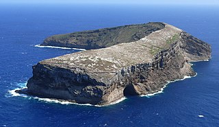
WNuʻutele is an island which consists of a volcanic tuff ring situated 1.3 km off the eastern end of Upolu island, Samoa. It is the largest of the four Aleipata Islands, at 1.08 km2.
 W
WPunchbowl Crater is an extinct volcanic tuff cone located in Honolulu, Hawaii. It is the location of the National Memorial Cemetery of the Pacific.
 W
WSalt Lake is a neighborhood of Honolulu, Hawaii on the island of O‘ahu. The area is also known as Āliamanu after a nearby crater, although Salt Lake itself is in a crater called Ālia pa‘akai — meaning "salt pond" in the Hawaiian language. The Salt Lake community was developed in the 1960s during a construction boom, providing residents with an expansive view of downtown Honolulu and the sugarcane plantations of the central plain of O‘ahu. It is a community of high-rise condominiums, mid-rise town-dwellings, and houses snaking around the remnants of a now freshwater lake.
 W
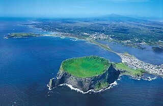
WSeongsan Ilchulbong, also called ‘Sunrise Peak’, is an archetypal tuff cone formed by hydrovolcanic eruptions upon a shallow seabed about 5 thousand years ago. Situated on the eastern seaboard of Jeju Island and said to resemble a gigantic ancient castle, this tuff cone is 182 meters high, has a preserved bowl-like crater and also displays diverse inner structures resulting from the sea cliff. These features are considered to be of geologic worth, providing information on eruptive and depositional processes of hydromagmatic volcanoes worldwide as well as past volcanic activity of Seongsan Ilchulbong itself.
 W
WVivara is a satellite islet of Procida, one of the three main islands in the Gulf of Naples.