 W
WThe Colorado River Storage Project is a United States Bureau of Reclamation project designed to oversee the development of the upper Colorado River basin. The project provides hydroelectric power, flood control and water storage for participating states along the upper portion of the Colorado River and its major tributaries.
 W
WBlue Mesa Dam is a 390-foot-tall (120 m) zoned earthfill dam on the Gunnison River in Colorado. It creates Blue Mesa Reservoir, and is within Curecanti National Recreation Area just before the river enters the Black Canyon of the Gunnison. The dam is upstream of the Morrow Point Dam. Blue Mesa Dam and reservoir are part of the Bureau of Reclamation's Wayne N. Aspinall Unit of the Colorado River Storage Project, which retains the waters of the Colorado River and its tributaries for agricultural and municipal use in the American Southwest. The dam's primary purpose is hydroelectric power generation. State Highway 92 passes over the top of the dam. Blue Mesa Dam houses two turbine generators and produces an average of 264,329,000 kilowatt-hours each year.
 W
WBlue Mesa Reservoir is an artificial reservoir located on the upper reaches of the Gunnison River in Gunnison County, Colorado. The largest lake located entirely within the state, Blue Mesa Reservoir was created by the construction of Blue Mesa Dam, a 390-foot tall earthen fill dam constructed on the Gunnison by the U.S. Bureau of Reclamation in 1966 for the generation of hydroelectric power. Managed as part of the Curecanti National Recreation Area, a unit of the National Park Service, Blue Mesa Reservoir is the largest lake trout and Kokanee salmon fishery in Colorado.
 W
WBridge Canyon Dam, also called Hualapai Dam, was a proposed dam in the lower Grand Canyon of the Colorado River, in northern Arizona in the United States. It would have been located near Bridge Canyon Rapids in an extremely rugged and isolated portion of the canyon, 235 miles (378 km) downstream of Lee's Ferry and at the uppermost end of Lake Mead.
 W
WCrystal Dam is a 323-foot-tall (98 m), double-curvature, concrete, thin arch dam located 6 miles downstream from Morrow Point Dam on the Gunnison River in Colorado, United States. Crystal Dam is the newest of the three dams in Curecanti National Recreation Area; construction on the dam was finished in 1976. The dam impounds Crystal Reservoir. Crystal Dam and Reservoir are part of the Bureau of Reclamation's Wayne N. Aspinall Unit of the Colorado River Storage Project, which retains the waters of the Gunnison River and its tributaries for agricultural and municipal use in the American Southwest. The dam's primary purpose is hydroelectric power generation.
 W
WCrystal Reservoir is a 340-acre artificial reservoir on the Gunnison River in western Colorado. Located in the upper Black Canyon of the Gunnison, the lake was created in 1976 by the U.S. Bureau of Reclamation as part of a larger plan to impound the upper section of the Gunnison for the generation of hydroelectric power, water storage, and public recreation. Crystal Reservoir is managed by the National Park Service as an element of the Curecanti National Recreation Area. Located at the far western end of Curecanti, Crystal Reservoir is the smallest, least developed, and least accessible of the three reservoirs within the park.
 W
WThe Dolores Project, located in the Dolores and San Juan River basins in southwestern Colorado, uses water from the Dolores River for irrigation, municipal and industrial use, recreation, fish and wildlife, and production of hydroelectric power. It also provides flood control and aids in economic redevelopment. The primary storage of Dolores River flows for all project purposes is provided by the McPhee Reservoir. Service is provided to the northwest Dove Creek area, central Montezuma Valley area, and south to the Towaoc area on the Ute Mountain Ute Indian Reservation. Irrigation water is available for 61,660 acres (249.5 km2).
 W
WEcho Park Dam was proposed in the 1950s by the U.S. Bureau of Reclamation as a central feature of the Colorado River Storage Project. Situated on the Green River, a major tributary of the Colorado River, the dam was proposed for the Echo Park district of Dinosaur National Monument, flooding much of the Green and Yampa river valleys in the monument. The dam was bitterly opposed by preservationists, who saw the encroachment of a dam into an existing national park as another Hetch Hetchy, to be opposed as an appropriation of protected lands for development purposes. A compromise led to the abandonment of the Echo Park project in favor of Glen Canyon Dam on the main stem of the Colorado in lands that were not at that time protected.
 W
WFlaming Gorge Dam is a concrete thin-arch dam on the Green River, a major tributary of the Colorado River, in northern Utah in the United States. Flaming Gorge Dam forms the Flaming Gorge Reservoir, which extends 91 miles (146 km) into southern Wyoming, submerging four distinct gorges of the Green River. The dam is a major component of the Colorado River Storage Project, which stores and distributes upper Colorado River Basin water.
 W
WFlaming Gorge Reservoir is the largest reservoir in Wyoming, on the Green River, impounded behind the Flaming Gorge Dam. Construction on the dam began in 1958 and was completed in 1964. The reservoir stores 3,788,900 acre feet (4.6735×10⁹ m3) of water when measured at an elevation of 6,040 feet (1,841 m) above sea-level (maximum).
 W
WFontenelle Dam was built between 1961 and 1964 on the Green River in southwestern Wyoming. The 139-foot (42 m) high zoned earthfill dam impounds the 345,360-acre-foot (0.42600 km3) Fontenelle Reservoir. The dam and reservoir are the central features of the Seedskadee Project of the U.S. Bureau of Reclamation, which manages the Fontenelle impoundment primarily as a storage reservoir for the Colorado River Storage Project. The dam suffered a significant failure in 1965, when the dam's right abutment developed a leak. Emergency releases from the dam flooded downstream properties, but repairs to the dam were successful. However, in 1983 the dam was rated "poor" under Safety Evaluation of Existing Dams (SEED) criteria, due to continuing seepage, leading to an emergency drawdown. A concrete diaphragm wall was built through the core of the dam to stop leakage.
 W
WFontenelle Reservoir is an artificial reservoir located in southwest Wyoming. It lies almost entirely within Lincoln County, although the east end of the Fontenelle Dam and a tiny portion of the reservoir are actually in northwestern Sweetwater County. Impounded by Fontenelle Dam, the reservoir acts primarily as a storage reservoir for the U.S. Bureau of Reclamation's Colorado River Storage Project, retaining Wyoming water in the state as a means of asserting Wyoming's water rights, with a secondary purpose of power generation. Water from Fontenelle Reservoir is used in local industries such as mining and power generation. Although initially projected to provide irrigation water for agriculture, the irrigation component was downgraded after difficulties with efficient irrigation in Wyoming's high semi-desert became apparent.
 W
WGlen Canyon Dam is a concrete arch-gravity dam on the Colorado River in northern Arizona, United States, near the town of Page. The 710-foot (220 m) high dam was built by the U.S. Bureau of Reclamation (USBR) from 1956 to 1966 and forms Lake Powell, one of the largest man-made reservoirs in the U.S. with a capacity of 27 million acre feet (33 km3). The dam is named for Glen Canyon, a series of deep sandstone gorges now flooded by the reservoir; Lake Powell is named for John Wesley Powell, who in 1869 led the first expedition to traverse the Colorado's Grand Canyon by boat.
 W
WLake Powell is a man-made reservoir on the Colorado River in Utah and Arizona, United States. It is a major vacation spot visited by approximately two million people every year. It is the second largest man-made reservoir by maximum water capacity in the United States behind Lake Mead, storing 24,322,000 acre feet (3.0001×10¹⁰ m3) of water when full. However, due to high water withdrawals for human and agricultural consumption, and because of subsequent droughts in the area, Lake Mead has fallen below Lake Powell in size several times during the 21st century in terms of volume of water, depth and surface area.
 W
WThe Marble Canyon Dam, also known as the Redwall Dam, was a proposed dam on the Colorado River in Arizona. The dam was intended to impound a relatively small reservoir in the central portion of Marble Canyon to develop hydroelectric power. Plans centered on two sites between miles 30 and 40 in the canyon. At one point a 38-mile (61 km) tunnel was proposed to a site just outside Grand Canyon National Park to develop the site's full power generation potential, reducing the Colorado River to a trickle through the park.
 W
WMorrow Point Dam is a 468-foot-tall (143 m) concrete double-arch dam on the Gunnison River located in Colorado, the first dam of its type built by the U.S. Bureau of Reclamation. Located in the upper Black Canyon of the Gunnison, it creates Morrow Point Reservoir, and is within the National Park Service-operated Curecanti National Recreation Area. The dam is between the Blue Mesa Dam (upstream) and the Crystal Dam (downstream). Morrow Point Dam and reservoir are part of the Bureau of Reclamation's Wayne N. Aspinall Unit of the Colorado River Storage Project, which retains the waters of the Colorado River and its tributaries for agricultural and municipal use in the American Southwest. The dam's primary purpose is hydroelectric power generation.
 W
WMorrow Point Reservoir is an 817-acre artificial reservoir on the Gunnison River in western Colorado. Located in the upper Black Canyon of the Gunnison, the lake was created in 1968 by the U.S. Bureau of Reclamation as part of a larger plan to impound the upper section of the Gunnison and create opportunities for hydroelectric power generation, water conservation, and recreation. Morrow Point Reservoir is managed by the National Park Service as a unit within the Curecanti National Recreation Area, and is the location of the Curecanti Needle, a striking 700 ft. granite spire on the reservoir's southern bank whose unique shape was for decades a recognized symbol of the Denver and Rio Grande Western Railroad.
 W
WNavajo Dam is a dam on the San Juan River, a tributary of the Colorado River, in northwestern New Mexico in the United States. The 402-foot (123 m) high earthen dam is situated in the foothills of the San Juan Mountains about 44 miles (71 km) upstream and east of Farmington, New Mexico. It was built by the U.S. Bureau of Reclamation (Reclamation) in the 1960s to provide flood control, irrigation, domestic and industrial water supply, and storage for droughts. A small hydroelectric power plant was added in the 1980s.
 W
WNavajo Lake is a reservoir located in San Juan County and Rio Arriba County in northwestern New Mexico, in the southwestern United States. Portions of the reservoir extend into Archuleta County in southern Colorado. The lake is part of the Colorado River Storage Project, which here manages the upper reaches of the San Juan River, storing and releasing water that is used locally for irrigation, or ultimately reaching the Colorado River in Utah. Water is impounded in Navajo Lake by the earth- and rock-filled Navajo Dam, 3,800 feet (1,200 m) long and 400 feet (120 m) high, completed in 1962. The 15,600-acre (63 km2) lake is over 25 miles (40 km) long and lies at an elevation of up to 6,085 feet (1,855 m).
 W
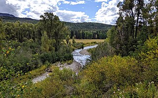
WRio Blanco is a stream that is tributary of the San Juan River in southern Colorado, United States. The stream originates in the San Juan Mountains and flows for 30 miles (48 km) through the San Juan National Forest and private lands to its confluence with the San Juan River in Archuleta County, Colorado. Colorado classifies the Rio Blanco as an Aquatic Life Coldwater Class 1/Recreation Class 1 waterway supporting water supply and agricultural uses. The river also features native cutthroat trout and introduced rainbow trout fishing.
 W
WThe San Juan–Chama Project is a U.S. Bureau of Reclamation interbasin water transfer project located in the states of New Mexico and Colorado in the United States. The project consists of a series of tunnels and diversions that take water from the drainage basin of the San Juan River – a tributary of the Colorado River – to supplement water resources in the Rio Grande watershed. The project furnishes water for irrigation and municipal water supply to cities along the Rio Grande including Albuquerque and Santa Fe.
 W
WPart of the Uncompahgre Project located on the western slope of central Colorado, the Taylor Park Dam was engineered by the Bureau of Reclamation. It is located on the Taylor River, a tributary of the Gunnison River, and the dam is used to create the Taylor Park Reservoir in Gunnison County, Colorado.