 W
WList of mountains in Kenya is a general list of mountains in Kenya with elevation. The highest mountain in Kenya, which is also the second-highest mountain in Africa, is Mount Kenya, standing at 5,199 metres (17,057 ft) tall.
 W
WMount Elgon is an extinct shield volcano on the border of Uganda and Kenya, north of Kisumu and west of Kitale. The mountain's highest point, named "Wagagai", is located entirely within Uganda. Although there is no verifiable evidence of its earliest volcanic activity, geologists estimate that Mount Elgon is at least 24 million years old, making it the oldest extinct volcano in East Africa.
 W
WMount Homa is a mountain located in western Kenya. It forms a broad peninsula on the southern shore of Winam Gulf, an extension of Lake Victoria. This peninsula defines Homa Bay and the mountaintop is about 20 kilometres north of the town of that name.
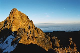
WMount Kenya is the highest mountain in Kenya and the second-highest in Africa, after Kilimanjaro. The highest peaks of the mountain are Batian, Nelion and Point Lenana. Mount Kenya is located in the former Eastern and Central provinces of Kenya, now Meru, Embu, Laikipia, Kirinyaga, Nyeri and Tharaka Nithi counties, about 16.5 kilometres south of the equator, around 150 km (90 mi) north-northeast of the capital Nairobi. Mount Kenya is the source of the name of the Republic of Kenya.
 W
WOl Donyo Sabuk, or Kyanzavi in Kamba, is a mountain and an adjacent small town near Thika Kenya. The town is located in Kyanzavi Division, Machakos County. The peak, height 2,145 metres (7,037 ft), was named by Maasai pastoralists, meaning big mountain. The Kamba name, Kyanzavi means the mountain of nzavi or Lablab beans. Kilimambogo, has two parts, Kilima - meaning a hill or mountain in Swahili, and mbogo meaning a buffalo in many Bantu languages. Incidentally, the forested part of the mountain has a large population of buffaloes. Buffalo is called Nyati in Swahili. The town stands at the edge of Machakos County.
WOl Donyo Sabuk, or Kyanzavi in Kamba, is a mountain and an adjacent small town near Thika Kenya. The town is located in Kyanzavi Division, Machakos County. The peak, height 2,145 metres (7,037 ft), was named by Maasai pastoralists, meaning big mountain. The Kamba name, Kyanzavi means the mountain of nzavi or Lablab beans. Kilimambogo, has two parts, Kilima - meaning a hill or mountain in Swahili, and mbogo meaning a buffalo in many Bantu languages. Incidentally, the forested part of the mountain has a large population of buffaloes. Buffalo is called Nyati in Swahili. The town stands at the edge of Machakos County.
WMount Kinangop is a mountain in the southern Aberdare Range about 100 miles (160 km) north of Nairobi, Kenya. It is within the Aberdare National Park.
WMount Kipipiri is an isolated volcano in the Wanjohi Valley, on the Kinangop Plateau near to the Aberdare Range. It is about 20 miles (32 km) northeast of Lake Naivasha, which is visible from the summit. Wildlife includes Colobus and Sykes monkeys, elephants and buffalo and abundant birdlife. The name of the mountain means "butterfly" in the Gikuyu language, a reference to its profile from a distance.
WKorosi is a shield volcano located in the Gregory Rift at the northern end of Lake Baringo, Kenya.
 W
WMount Longonot is a stratovolcano located southeast of Lake Naivasha in the Great Rift Valley of Kenya, Africa. It is thought to have last erupted in the 1860s. Its name is derived from the Maasai word Oloonong'ot, meaning "mountains of many spurs" or "steep ridges".
 W
WMarsabit is a 6300 km2 basaltic shield volcano in Kenya, located 170 km east of the center of the East African Rift, in Marsabit County near the town of Marsabit. This was primarily built during the Miocene, but some lava flows and explosive maar-forming eruptions have occurred more recently. At least two of the maars host crater lakes.
 W
WMenengai Crater is a massive shield volcano with one of the biggest calderas in the world, in the Great Rift Valley, Kenya. It is the largest volcano caldera in Kenya and the second largest volcano caldera in Africa. Volcanic formed rich loam soils enrich the adjacent farmland arounds its flanks. The crater is on the floor of the Rift Valley. The volcano formed about 200,000 years ago and the prominent 12 x 8 km caldera formed about 8000 years ago. The caldera floor is covered with numerous post caldera lava flows. The Menengai volcano is considered one of the best-preserved Krakatau-style calderas in the world. Menengai has very little sediment in the caldera which is a thick mass of lava boulders and inaccessible ridges. Volcanic activity continues and a current project under the GDC is at an advanced stage towards geothermal power generation.
WMount Mtelo (Sekerr) is the fifth-highest mountain in Kenya (3336m/10,944 ft), after Mt Kenya, Mt Elgon, Aberdares and High Cheranganis, and is situated in the North West highlands of West Pokot County, approximately 120 km north of Kitale Town.
 W
WNamarunu is a shield volcano located in the Great Rift Valley, Kenya.
WMount Ng'iro is a mountain in the north of Kenya overlooking the Suguta Valley, part of the Great Rift Valley, to the west. The mountain is surrounded by desert, but is forested on its upper slopes. It lies in the territory of the Samburu people. The Masula phratry of these people cultivate bees on the mountain, and as bee-keepers claim exclusive rights to the land and water.
 W
WOl Doinyo Eburru is an active complex of volcanoes in the Great Rift Valley, Kenya to the northwest of Lake Naivasha. It is being exploited for geothermal energy. Soysambu Conservancy is located to the north of the massif, between Lake Elmenteita to the east and Lake Nakuru to the west.
 W
WThe Ol Donyo Orok mountain, also called Namanga Hills, is situated in southern Kenya next to the Tanzanian border in the Namanga Division. The mountain has a stretched triangular shape, almost like an arrow pointing north. The short side faces the Tanzanian border. The highest peak is 2548 m.
WOl Donyo Sabuk, or Kyanzavi in Kamba, is a mountain and an adjacent small town near Thika Kenya. The town is located in Kyanzavi Division, Machakos County. The peak, height 2,145 metres (7,037 ft), was named by Maasai pastoralists, meaning big mountain. The Kamba name, Kyanzavi means the mountain of nzavi or Lablab beans. Kilimambogo, has two parts, Kilima - meaning a hill or mountain in Swahili, and mbogo meaning a buffalo in many Bantu languages. Incidentally, the forested part of the mountain has a large population of buffaloes. Buffalo is called Nyati in Swahili. The town stands at the edge of Machakos County.
 W
WThe Olkaria Area is a region located immediately to the south of Lake Naivasha in the Great Rift Valley of Kenya, Africa. It is geothermally active and is being used to generate clean electric power. The region has an estimated potential of 2,000 MW. This is almost double the maximum daily electricity peak demand recorded in 2008/2009 for the entire country.
WPaka is a shield volcano located in the Great Rift Valley, Kenya. Geothermal activity is widespread at Paka. Paka means "ochre" in Pokot.
WMount Satima, also known as Mount Lesatima and often abbreviated to Satima or Lesatima, is the third-highest mountain in Kenya and the highest in the Aberdare Range. The Maasai name is Oldoinyo Lesatima, which has a variety of alternative spellings, such as Ol Donyo Le Satima, and means "mountain of the bull calf".
 W
WMount Suswa is a shield volcano in the Great Rift Valley, Kenya. It is located between Narok and Nairobi, the capital of Kenya. The northwestern part of Mount Suswa is in Narok County, while the eastern and southern part are in Kajiado County. The town with the same name, Suswa, is just northwest of the mountain and it is the main access point for visits to the mountain.