 W
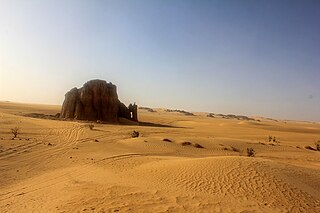
WThe Adrar is a highland natural and historical region of the Sahara Desert in northern Mauritania. The Adrar Region, an administrative division of Mauritania, is named after the traditional region. It is sometimes called Adrar Tamar to distinguish it from other areas called Adrar in the Sahara.
 W
WAoukar or Erg Aoukar is a geological depression area of south eastern Mauritania. It is located between Kiffa and Néma, south of the Tagant Plateau. The Aoukar basin is a dry natural region of sand dunes and salt pans fringed by escarpments on its northern and eastern sides.
 W
WAurès is an Amazigh language-speaking natural region located in the mountainous area of the Aurès range in eastern Algeria. The region includes the Algerian provinces of Batna, Tebessa, Khenchela, Oum El Bouaghi, Souk Ahras and Biskra.
 W
WCorniche Jjilienne is a natural region of northern Algeria characterised by rocky forested massifs rising above the coastal plain. The forested areas provide some of the last extant habitat for the endangered Barbary macaque, Macaca sylvanus; this primate prehistorically had a much wider distribution in North Africa than at present.
 W
Wel-Djerid, al-Jarīd or more precisely the South Western Tunisia Region is a semi-desert natural region comprising three southern Tunisian Governorates, Gafsa, Kebili and Tozeur with adjacent parts of Algeria and Libya.
 W
WDoukkala is a natural region of Morocco made of fertile plains and forests. Nowadays it is part of the Casablanca-Settat administrative region.
 W
WThe Erg Admer is a large erg or field of sand dunes in the Sahara Desert. Situated in the Illizi Province west of the oasis town of Djanet in south-eastern Algeria, the erg covers an area some 20 km wide by some 100 km large north to south. It originates in the centre of Tassili n'Ajjer, towards Essendilène and extends southwards to reach Ténéré at the Niger border.
 W
WThe Erg Chech, is a large erg in southwestern Algeria and northern Mali.
 W
WThe Erg Iguidi, is a large erg in the area of Tindouf in southwestern Algeria extending into northern Mali and Mauritania.
 W
WThe Grand Erg Occidental, is the second largest erg in northern Algeria after the Grand Erg Oriental. It covers an area of approximately 78,000 square kilometres (30,000 sq mi). The sand dunes in the erg are formed by the wind, and can be up to 120 metres (390 ft) high. Certain crescent-shaped dunes, known as barchans, are actually mobile; the wind can push these dunes as much as 20 to 30 m in one year.
 W
WThe Grand Erg Oriental is a large erg or "field of sand dunes" in the Sahara Desert. Situated for the most part in Saharan lowlands of northeast Algeria, the Grand Erg Oriental covers an area some 600 km wide by 200 km north to south. The erg's northeastern edge spills over into neighbouring Tunisia.
 W
WThe Hautes Plaines, also known as Hauts Plateaux, is a steppe-like natural region located in the Atlas Mountains in northern Algeria. It stretches more than 600 km (370 mi) in an east northeast – west southwest direction from northeastern Morocco to the Aures. It is a high plateau area consisting of undulating, steppe-like alluvial plains lying between the Tell and Saharan Atlas ranges.
 W
WThe Hodna is a natural region of Algeria located between the Tell and Saharan Atlas ranges at the eastern end of the Hautes Plaines. It is a vast depression lying in the northeastern section of M'Sila Province and the western end of Batna Province.
 W
WThe Issaouane Erg is an approximately 38,000 km2 erg in Algeria's portion of the Sahara desert, located at 27.83°N 7.23°E.
 W
WKabylia is a cultural, natural and historical region in northern Algeria. It is part of the Tell Atlas mountain range, and is located at the edge of the Mediterranean Sea.
 W
WMugamba is a natural region in the Bururi Province of Burundi. The Rugo is a traditional Burundian house of the region. There is also a town named Mugamba in the Mugamba Commune located in the region.
 W
WPetite Kabylie or Petite Kabylia is a natural region in the mountainous area of northern Algeria. The Petite Kabylie is part of the greater Kabylie region.
 W
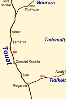
WTademaït is a natural region in the Sahara Desert right in the centre of Algeria. It is located north of In Salah and south of the Grand Erg Occidental in the Adrar District of Adrar Province, El Ménia District of Ghardaïa Province and the northern end of Tamanrasset Province. It is one of the places of the Sahara Desert where the summer heat is most extreme.
 W
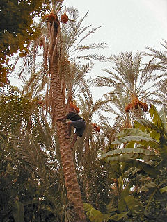
WThe Tagant Plateau is located in eastern Mauritania, forming a stony part of the Sahara Desert. The Tagant Region, a national administrative division, is named after the plateau.
 W
WTamasna is a historical region between Bou Regreg and Tensift in Morocco. It includes the modern regions of Chaouia, Doukkala, Abda, Rhamna, Sraghna and Chiadma. The indigenous population is that of Barghwata who were driven by the Almohads who installed the Bedouin Arabs.
 W
WThe Tanezrouft is a natural region located along the borders of Algeria, Niger and Mali, west of the Hoggar mountains. It is one of the most desolate parts of the Sahara Desert.
 W
WTuat, or Touat, is a natural region of desert in central Algeria that contains a string of small oases. In the past, the oases were important for caravans crossing the Sahara.