 W
WBuzi River is a river in Mozambique. The Buzi River originates in the Eastern Highlands on the border of Mozambique and Zimbabwe, and flows eastward through Manica and Sofala provinces of Mozambique. It empties to the Mozambique Channel west of Beira, forming a large estuary with the Pungwe River.
 W
WThe Changane River is a river in Mozambique, a tributary to the Limpopo River which it joins near the coast, just past the town of Chibuto. It forms part of the eastern boundary of Gaza Province. The Changane is the easternmost tributary of the Limpopo, entering it from the left near its mouth on the Indian Ocean
 W
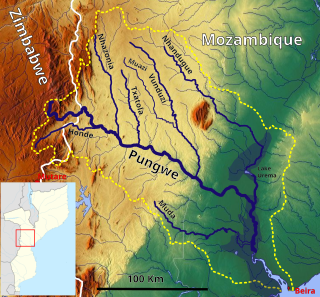
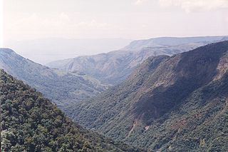
WHonde River pronounced Horn-de is a river in Eastern Highlands of Zimbabwe which runs through the Honde Valley. It flows from Mount Inyangani on the western edges of Honde Valley where it is joined by several of its major tributaries: the rivers Mupenga, Buu, Mtarazi and Ngarura. It deposits its waters into the Pungwe River which in turn empties in the Indian Ocean.
 W
WThe Komati River is a river in South Africa, Eswatini and Mozambique. It is 480 kilometres (298 mi) long, with a drainage basin 50,000 square kilometres (19,300 sq mi) in size. Its mean annual discharge is 111 m3/s at its mouth.
 W
WThe Limpopo River rises in South Africa, and flows generally eastwards through Mozambique to the Indian Ocean. The term Limpopo is derived from Rivombo (Livombo/Lebombo), a group of Tsonga settlers led by Hosi Rivombo who settled in the mountainous vicinity and named the area after their leader. The river is approximately 1,750 kilometres (1,087 mi) long, with a drainage basin 415,000 square kilometres (160,200 sq mi) in size. The mean discharge measured over a year is 170 m3/s at its mouth. The Limpopo is the second largest river in Africa that drains to the Indian Ocean, after the Zambezi River.
 W
WThe Lugenda or Lujenda is a river of northern Mozambique. It flows in a south-north direction from Lake Amaramba/Lake Chiuta and is the largest tributary of the Ruvuma River. It joins the Luambala River at 13°26′12″S 36°18′20″E. The river valley is reported to be only 800 feet (240 m) above sea level. North of Lake Chiuta, those on the west bank call it the Msambiti River. At one point, the Lugenda splits into several streams with islands between them, some of whom are populated such as the island Achemponda.
 W
WThe Manyame River, also known as Panhame and formerly as Hunyani is a river located in Zimbabwe and Mozambique, and a tributary of the Zambezi River.
 W
WThe Maputo River, also called Great Usutu River, Lusutfu River, or Suthu River, is a river in South Africa, Eswatini, and Mozambique. The name Suthu refers to Basotho people who lived near the source of the river, but were attacked and displaced by Swazis. It is also said to mean 'dark brown', a description of the river's muddy water.
 W
WThe Mazowe River is a river in Zimbabwe and Mozambique.
 W
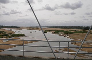
WThe Mbuluzi River is one of the main rivers of Eswatini, and an important river in Mozambique. On the boundary of these countries, the Mbuluzi cuts through the Lebombo Range, before entering the Mozambican plain. It empties into the Estuário do Espírito Santo and then Maputo Bay at Maputo, and its waters pass under the Maputo–Katembe bridge, completed in 2018.
 W
WThe Messalo is a major river of northeastern Mozambique. It flows through Niassa Province and Cabo Delgado Province, passes near Chai, and flows into the Mozambique Channel of the Indian Ocean at Quiterajo beach at 11°40′25″S 40°26′25″E. The Messalo River is 530 km (330 mi) in length while the Messalo River Basin is 24,000 km2 (9,300 sq mi) in size. The river flooded its banks in March 2000 during the 2000 Mozambique flood.
 W
WThe Montepuez River is a river of Mozambique. It flows to the south of the Ruvuma River, and is characterised by seasonal flows and lined by swamps.
 W
WMuar River is a stream in Sofala province of Mozambique.
 W
WMwenezi River is a major tributary of the Limpopo River. The Mwenezi River starts up in south central Zimbabwe and flows south-east along what is known as the Mwenezi River Valley that bisects the district into two sectors. The river is found in both Zimbabwe and Mozambique. In Zimbabwe it has been known as the Nuanetsi or Nuanetzi River in the past, a name it retains in Mozambique.
 W
WThe Ngalamu River is a river of northern Mozambique and Malawi, located to the west of Lake Amaramba. It is located at 14°24′0″S 35°41′0″E.
 W
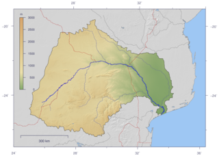
WPungwe River is a 400 km (250 mi) long river in Zimbabwe and Mozambique. It rises below Mount Nyangani in the Eastern Highlands of Zimbabwe and then flows southeasteastward through the Manica and Sofala provinces of Mozambique. the Pungwe enters the Urema Valley, the southernmost portion of the Great Rift Valley, where it forms the southern boundary of Gorongosa National Park. The Urema River joins it, and the river follows the rift valley southward. Large seasonal wetlands form around the Pungwe and Urema rivers in the rift valley section. It empties into the Mozambique Channel at Beira, forming a large estuary. It is one of the major rivers of Mozambique and often causes floods.
 W
WThe Revúboé River is a river in Mozambique. The river is a large perennial tributary of the Zambezi river.
 W
WRuo River is the largest tributary of the Shire River in southern Malawi and Mozambique. It originates from the Mulanje Massif (Malawi) and forms 80 km (50 mi) of the Malawi-Mozambique border. It joins the Shire River at Chiromo.
 W
WRuvuma River, formerly also known as the Rovuma River, is a river in the African Great Lakes region. During the greater part of its course, it forms the border between Tanzania and Mozambique. The river is 800 kilometres (497 mi) long, with a drainage basin of 155,500 square kilometres (60,000 sq mi) in size. Its mean annual discharge is 475 m³/s at its mouth.
 W
WThe Save River, or Sabi River is a 400 mi (640 km) river of southeastern Africa, flowing through Zimbabwe and Mozambique. The river has its source in Zimbabwe, some 80 km (50 mi) south of Harare, then flows south and then east, from the Zimbabwean highveld to its confluence with the Odzi River. It then turns south, drops over the Chivirira Falls, and flows down the western side of Zimbabwe's Eastern Highlands forming a dry river valley in the rain shadow of these mountains. It is joined by the Runde River or Lundi at the Mozambique border, forming a dramatic confluence at Mahenya. It then crosses Mozambique to flow into the Indian Ocean at about 21°S.
 W
WThe Shire is the largest river in Malawi. The river has been known as the Shiré or Chire River. It is the only outlet of Lake Malawi and flows into the Zambezi River in Mozambique. Its length is 402 kilometres (250 mi). The upper Shire River issues from Lake Malawi and runs approximately 12 miles before it enters shallow Lake Malombe. It then drains Lake Malombe and flows south through Liwonde National Park where large concentrations of hippopotamus are common along its shores. Between the towns of Matope and Chikwawa, the middle river drops approximately 1,300 feet through a series of falls and gorges, including Kapachira Falls. Two hydroelectric dams have been built along the Shire northwest of Blantyre.
 W
WThe Zambezi is the fourth-longest river in Africa, the longest east-flowing river in Africa and the largest flowing into the Indian Ocean from Africa. The area of its basin is 1,390,000 square kilometres (540,000 sq mi), slightly less than half of the Nile's. The 2,574-kilometre-long river (1,599 mi) arises in Zambia and flows through eastern Angola, along the north-eastern border of Namibia and the northern border of Botswana, then along the border between Zambia and Zimbabwe to Mozambique, where it crosses the country to empty into the Indian Ocean.