 W
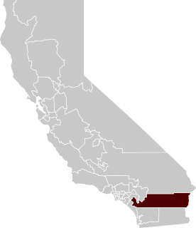
WBlythe is a city in eastern Riverside County, California, United States. It is in the Palo Verde Valley of the Lower Colorado River Valley region, an agricultural area and part of the Colorado Desert along the Colorado River, approximately 224 miles (360 km) east of Los Angeles and 150 miles (240 km) west of Phoenix. Blythe was named after Thomas Henry Blythe, a San Francisco financier, who established primary water rights to the Colorado River in the region in 1877. The city was incorporated on July 21, 1916. The population was 20,817 at the 2010 census.
 W
WThe Arica Mountains are a small mountain range in northern Riverside County, California. The range lies along the south edge of Rice Valley 6.2 miles (10.0 km) southwest of the old Rice townsite on California State Route 62. They lie 6 miles (9.7 km) north of the Little Maria Mountains and 9 miles (14 km) southwest of the Turtle Mountains. The Granite Mountains lie about 8 miles to the west. They are in the Colorado Desert, in the Lower Colorado River Valley region. They are north the Palen Mountains and Big Maria Mountains; and northwest of Blythe, California.
 W
WBlythe Airport is seven miles west of Blythe, in Riverside County, California, United States. The National Plan of Integrated Airport Systems for 2011–2015 categorized it as a general aviation facility.
 W
WThe Blythe Heat were a professional baseball team based in Blythe, California. They played in the Arizona Winter League, a short-season instructional winter league affiliated with the North American League. They began play in 2007 and played their home games at Alexander Field in Blythe. They are the only team in the instructional league that play their home games somewhere other than the league's home base of Yuma, Arizona's Desert Sun Stadium. They were owned by Diamond Sports & Entertainment. The team's uniform logo was that of the former Western Baseball League team, the Chico Heat, predecessors to the GBL's Chico Outlaws.
 W
WThe Blythe Intaglios or Blythe Geoglyphs are a group of gigantic figures incised on the ground near Blythe, California, in the Colorado Desert. The ground drawings or geoglyphs were created by humans for an, as yet, unknown reason.
 W
WThomas Henry Blythe, born Thomas Williams in Mold, Flintshire, Wales, became a successful self-made capitalist and tycoon after emigrating to San Francisco in the United States. Blythe is most remembered for purchasing, developing, and subdividing the Palo Verde Valley in southern California, and obtaining primary rights to Colorado River water to irrigate the valley. The city of Blythe, California, the largest city in the Palo Verde Valley, is named for him.
 W
WCalifornia's 28th State Senate district is one of 40 California State Senate districts. After a May 13, 2020 special election to replace outgoing Senator Jeff Stone of La Quinta, incumbent State Assemblywoman, Melissa Melendez, became State Senator.
 W
WCalifornia's 36th congressional district is a U.S. congressional district in California. Based in the eastern part of Riverside County, it covers most of the desert communities of Palm Springs, Palm Desert, Indio, Coachella, Rancho Mirage, Desert Hot Springs, Indian Wells and Cathedral City in the Inland Empire.
 W
WCalifornia's 56th State Assembly district is one of 80 California State Assembly districts. It is currently represented by Democrat Eduardo Garcia of Coachella.
 W
WChuckawalla Valley State Prison (CVSP) is a male-only state prison located south of Interstate 10, in a detached section of Blythe, California in Riverside County. CVSP is adjacent to Ironwood State Prison.
 W
WEast Blythe is a former census-designated place (CDP) and unincorporated community in Riverside County, California, United States. The 2000 census population was three.
WIronwood State Prison (ISP) is a state prison located south of Interstate 10, in a detached section of Blythe, California, that lies west of the main portion of the city. It is located in eastern Riverside County, California, adjacent to Chuckawalla Valley State Prison.
WThe Little Maria Mountains are located in southeastern California in the United States. The range lies in a northwest-southeasterly direction east of the Palen Mountains and west of the Big Maria Mountains. The mountain range is approximately 15 miles long and is located about 12.6 miles north of Interstate 10, and 12 miles southwest of the abandoned Rice Army Airfield near State Route 62. The Victor Mine is found at the southeastern end of the range near Midland.
 W
WThe Low Desert is a common name for any desert in California that is under 2,000 feet (609.6m) in altitude. These areas include, but are not exclusive to, the Colorado Desert and Yuha Desert, in the Southern California portion of the Sonoran Desert. These areas are distinguished in biogeography from the adjacent northern High Desert or Mojave Desert by latitude, elevation, animal life, climate, and native plant communities.
 W
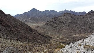
WThe McCoy Mountains are located in southeastern California in the United States. The southeast terminus of the range lies adjacent the western edge of the Parker Valley in a southern stretch of the Lower Colorado River Valley corridor.
WThe Mule Mountains of California are located in the southeastern part of the state in the United States. The range lies in a northeast-southwesterly direction south of the McCoy Mountains and west of the Palo Verde Valley and Colorado River. The mountain range is approximately 18 miles (29 km) long and is located just south of Interstate 10, about 5 mi (8 km) southeast of Chuckawalla Valley State Prison. The northern end of the range is in Riverside County, and the southern end is in Imperial County. Downtown Blythe, California is about 12 mi (19 km) to the northeast.
 W
WMystery of the Desert Giant is Volume 40 in the original The Hardy Boys Mystery Stories published by Grosset & Dunlap.
WThe Palen Mountains are located in the southern Mojave Desert – northern Colorado Desert in eastern Riverside County, California, USA. The range lies southeast of the Coxcomb Mountains, and northeast of the Chuckwalla Mountains near Interstate 10. The mountains lie in a southwest-northeasterly direction, and are approximately 15 miles long and nine miles wide at their widest point.
 W
WPalo Verde College, formerly Palo Verde Junior College, is a public community college in Blythe, California.
 W
WThe Palo Verde Dam is a diversion dam on the Colorado River in La Paz County, Arizona, and Riverside County, California, in the southwestern United States, approximately 9 miles (14 km) northeast of Blythe. The dam is earthen and rockfill, built solely to divert water into irrigation canals serving the Palo Verde Irrigation District. It measures 1,850 feet (560 m) long at its crest, which is at an elevation of 283.5 feet (86.4 m), and stands 46 feet (14 m) high above the riverbed, containing approximately 175,000 cubic yards (134,000 m3) of material. Construction of the dam, which began in 1956 and ended in 1958, was authorized by the U.S. Bureau of Reclamation. The dam was constructed to raise the water level of the river because the upstream Hoover and Davis Dams blocked sediment, causing significant degradation of the riverbed that hampered water diversion.
 W
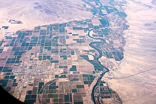
WThe Palo Verde Valley is located in the Lower Colorado River Valley, next to the eastern border of Southern California with Arizona, United States. It is located on the Colorado Desert within the Sonoran Desert south of the Parker Valley. Most of the valley is in Riverside County, with the southern remainder in Imperial County. La Paz County borders to the east on the Colorado River.
 W
WThe Sundesert Nuclear Power Plant was a proposed California nuclear power station, formally submitted in 1976. Facing firm opposition from the state's Governor Jerry Brown and denied a permit by a state agency, plans for the construction of the power facility were rejected in 1978 after 100 million dollars had been spent towards its construction. The Sundesert proposal was the last major attempt to build a nuclear plant in California.
 W
WW. R. Byron Airport is a privately owned, private use airport in Riverside County, California, United States. It is located four nautical miles northwest of the central business district of Blythe, California, within the city limits.