 W
WAustfjorden is a fjord in Spitsbergen, Svalbard in Arctic Norway. The fjord, measuring 32 kilometres is located in the east of the Indre Wijdefjorden National Park.
 W
WBellsund is a 20-kilometer (12 mi) long sound on the west coast of Spitsbergen, part of the Svalbard archipelago of Norway. It is separated from Van Mijenfjorden by the islands of Akseløya and Mariaholmen. Bellsund is located south of Nordenskiöld Land and north of Wedel Jarlsberg Land.
WBillefjorden is the central fjord of the three branching from the innermost part of the Isfjorden to the northeast, in Svalbard, Norway. It is 30 km long and 5–8 km wide. Billefjorden lies between Dickson Land to the northwest and Bünsow Land in the southeast. Located on its northwestern shore is the former Russian mining community of Pyramiden. To the northeast is Nordenskiöldbreen.
WDicksonfjorden is a fjord branch of Isfjorden at Spitsbergen, Svalbard. It is located between James I Land and Dickson Land, and is named after Swedish Baron Oscar Dickson.
WEkmanfjorden is an 18 km (11 mi) long fjord branching north from inner Isfjorden. It is separated by Nordfjorden to the south by Sveaneset in the west and Kapp Wærn in the east. It lies within Nordre Isfjorden National Park.
 W
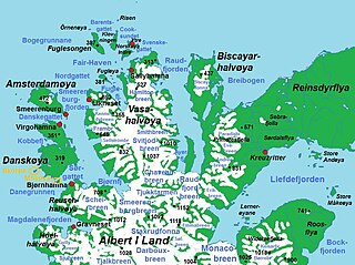
WFuglefjorden is a fjord in Albert I Land at Spitsbergen, Svalbard. It is located on the northern side of the peninsula Vasahalvøya, and has a length of three nautical miles. The island of Fugløya divides the fjord into two branches. The eastern branch has several islets, skerries and shoals.
WGrønfjorden is a 16 km long fjord, separated from Isfjorden to the north by Festningsodden in the west and Heerodden in the east. It lies within the western portion of Nordenskiöld Land. On its eastern shore is the mining community of Barentsburg, the second largest settlement on Spitsbergen.
WHornsund is a fjord on the western side of the southernmost tip of Spitsbergen island.
WIsfjorden is the second longest fjord in the Norwegian archipelago of Svalbard. It lies on the west side of Spitsbergen, an island in the Arctic Ocean about midway between Norway and the North Pole, and the largest in the archipelago. The mountain of Alkhornet stands on the northern side of the entrance to the fjord, as does the coastal plain of Daudmannsøyra. A portion of Isfjorden is included in the national parks of Norway as Nordre Isfjorden Land National Park. Around the fjord lie many of the largest settlements in Svalbard: Barentsburg, Longyearbyen and Pyramiden.
 W
WKongsfjorden is an inlet on the west coast of Spitsbergen, an island which is part of the Svalbard archipelago in the Arctic Ocean. The inlet is 26 km (16 mi) long and ranges in width from 6 to 14 km. Two glaciers, Kronebreen and Kongsvegen, head the fjord.
 W
WKrossfjorden is a 30 km long fjord on the west coast of Spitsbergen, which is the largest and only permanently populated island of the Svalbard archipelago in Norway. To the north, the fjord branches into Lillehöökfjorden, Möllerfjorden and Kollerfjorden. To the south it is separated from Kongsfjorden by a line from Collinsodden on Mitrahalvøya east to Kapp Guissez.
 W
WLilliehöökfjorden is a 14 kilometer long fjord branch of Krossfjorden in Albert I Land at the northwestern side of Spitsbergen, Svalbard. The fjord is named after Gustaf Bertil Lilliehöök.
WMagdalenefjorden is an 8 km long and up to 5 km wide fjord between Reuschhalvøya and Hoelhalvøya, Albert I Land, on the west coast of Spitsbergen, the largest island in the Svalbard archipelago. It is large enough to accommodate even the largest of cruise ships which are even able to turn through 180 degrees in the fjord. On the south shore of the fjord is the bay Gullybukta.
WRaudfjorden is a 20 km long and 5 km wide fjord on the northwestern coast of Spitsbergen. It has two southern branches, Klinckowströmfjorden and Ayerfjorden, split by the peninsula Buchananhalvøya. The fjord is situated on the divide between Albert I Land and Haakon VII Land.
WRecherche Fjord is a small fjord on the south side of Bellsund, Spitsbergen. The glacier Recherchebreen debouches into the fjord from south, and Renardbreen from west.
WSassenfjorden is a part of Isfjorden at Spitsbergen, Svalbard, in between Bünsow Land and Nordenskiöld Land. The inner branch of Sassenfjorden is named Tempelfjorden.
 W
WSorgfjorden is a fjord at the northeastern coast of Spitsbergen, Svalbard. It cuts into Ny-Friesland, from the northern part of Hinlopen Strait. It is also called Treurenberg Bay.
WTempelfjorden is a fjord branch at the inner end of Sassenfjorden, a part of Isfjorden at Spitsbergen, Svalbard. It is located between Sabine Land and Bünsow Land.
WVan Keulenfjorden is a 30 km long fjord on the west coast of Spitsbergen separating Nathorst Land to the north and Wedel Jarlsberg Land to the south. Van Keulenfjorden is separated from Bellsund by Forsbladodden in the north and Richardodden to the south.
WVan Mijenfjorden is the third-longest fjord in Norway's Svalbard archipelago. It lies in the southern portion of Spitsbergen island, south of Nordenskiöld Land and north of Nathorst Land. The fjord is 83 km (52 mi) long, being separated from Bellsund further out by Akseløya and Mariaholmen. The settlement of Sveagruva lies on the fjord's north bank.
WVestfjorden is the inner, western branch of Wijdefjorden, between Andrée Land and the northern part of Dickson Land in Spitsbergen, Svalbard in Arctic Norway. It is 12 km long and 5 km wide at the inlet between Kapp Petermann, Ræstadholmen and Krosspynten. Continues on land as Vestfjorddalen to the south and later southwest. Silty rivers comes from Landingsdalen, Yggbreen and Angelbreen on the west, as well as Vestfjorddalen in the south, giving the fjord a reddish look in contrast to the green colour of Wijdefjorden.Norwegian Polar Institute Place Names of Svalbard Database
WWijdefjord is the longest fjord in Norway's Svalbard archipelago. Wijdefjord is located in the northern portion of the island of Spitsbergen, which lies in the Arctic Ocean about midway between Norway and the North Pole, and is the largest island in the archipelago. The fjord is 108 km (67 mi) long. Opening on Spitsbergen's north coast, it runs roughly southwards into the interior, separating Andrée Land in the west from Margaretas Land in the east. The southern half of the fjord is part of Indre Wijdefjorden National Park.
 W
WWoodfjord is a fjord on the north shore of Spitsbergen island in the Svalbard archipelago. It is the fourth longest fjord in the Svalbard archipelago with the mouth facing north adjacent to Wijdefjord, and goes 64 km (40 mi) into the island, west of Andrée Land.