 W
WBanua Wuhu is a submarine volcano that rises more than 400 m (1,300 ft) from the sea floor in the Sangihe Islands of Indonesia. Historical records show that several ephemeral islands were formed and disappeared. A 90 m high island was formed in 1835, but then dwindled to only a few rocks in 1848. A new island was reportedly formed in 1889 and it was 50 m high in 1894. Another new island was formed in 1919 but then disappeared by 1935.
 W
WBowie Seamount is a large submarine volcano in the northeastern Pacific Ocean, located 180 km (110 mi) west of Haida Gwaii, British Columbia, Canada.
 W
WCortes Bank is a shallow seamount in the North Pacific Ocean. It is 96 miles southwest of San Pedro, Los Angeles, 111 miles west of Point Loma, San Diego, and 47 miles southwest of San Clemente Island in Los Angeles County. It is considered the outermost feature in California's Channel Islands chain. At various times during geologic history, the bank has been an island, depending on sea level rise and fall. The last time it was a substantial island was around 10,000 years ago during the last ice age. It is possible that this island was visited by the first human inhabitants of the Channel Islands, most notably San Clemente Island, whose seafaring residents would have been able to see the island from high elevations on clear days.
 W
WDom João de Castro Bank is a large submarine volcano located in the central north Atlantic Ocean, between the islands of São Miguel and Terceira in the archipelago of the Azores.
 W
WFukutoku-Okanoba (福徳岡ノ場) is a submarine volcano that is part of the Volcano Islands in the Bonin Islands of Japan. It is located 5 kilometers northeast of the island of South Iwo Jima.
 W
WThe Gorringe Ridge is a seamount in the Atlantic Ocean. It is located about 130 miles (210 km) west of Portugal, between the Azores and the Strait of Gibraltar along the Azores–Gibraltar fault zone. It is about 60 km wide and 180 km long in the northeast direction.
 W
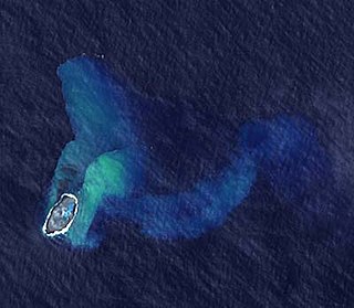
WGraham Island was an island created by a now fully submerged volcano in the Mediterranean Sea. It was discovered when it last appeared on 1 August 1831 by Humphrey Fleming Senhouse, the captain of the first rate Royal Navy ship of the line St Vincent and named after Sir James Graham, the First Lord of the Admiralty. It was claimed by the United Kingdom. It forms part of the underwater volcano Empedocles, 30 km (19 mi) south of Sicily, and which is one of a number of submarine volcanoes known as the Campi Flegrei del Mar di Sicilia. Seamount eruptions have raised it above sea level several times before erosion submerged it again.
 W
WThe Graveyard Seamounts, officially known as the Graveyard Knolls, are a series of 28 small seamounts and edifices located on the Chatham Rise, east of New Zealand. They cover about 140 km2 (54 sq mi) and stand out from the surrounding oceanic plateau that measures several hundred kilometers. They are named after various morose figures following the naming of the largest of the knolls as "the Graveyard" as it was a graveyard of fishing gear that became stuck on it. The most prominent among the group of knolls are Ghoul, Diabolical, Voodoo, Scroll, Hartless, Pyre, Gothic, Zombie, Mummy, Headstone, Morgue and Graveyard.
 W
WThe Great Meteor Seamount, also called the Great Meteor Tablemount, is a guyot and the largest seamount in the North Atlantic with a volume of 24,000 km3 (5,800 cu mi). It is one of the Seewarte Seamounts, rooted on a large terrace located south of the Azores Plateau. The crust underlying Great Meteor has an age of 85 million years, deduced from the magnetic anomaly 34 (An34) at this location.
 W
WHollister Ridge is a group of seamounts in the Pacific Ocean. They lie west from the Pacific-Antarctic Ridge and form three ridges that form a line; one of the ridges rises to a depth of 100 metres (330 ft) and in the past formed an island. The seamounts are composed out of basaltic and other rocks and their ages range from about 2.5 million years ago to latest Pleistocene; an acoustic swarm recorded in the southern Pacific Ocean in 1991-1992 is considered to be the manifestation of a historical eruption of the Hollister Ridge.
 W
WHome Reef is an ephemeral island built by a submarine volcano whose top has repeatedly broken the surface and afterwards was eroded away by wave action. It is in the South Pacific, south of Late Island and southwest of Vava'u along the Tofua volcanic arc in Tonga.
 W
WKick 'em Jenny is an active submarine volcano or seamount on the Caribbean Sea floor, located 8 km (5 mi) north of the island of Grenada and about 8 km (5 mi) west of Ronde Island in the Grenadines. Kick-'em-Jenny rises 1,300 m (4,265 ft) above the sea floor on the steep inner western slope of the Lesser Antilles ridge. The South American tectonic plate is subducting the Caribbean tectonic plate to the east of this ridge and under the Lesser Antilles island arc.
 W
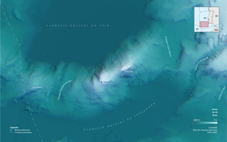
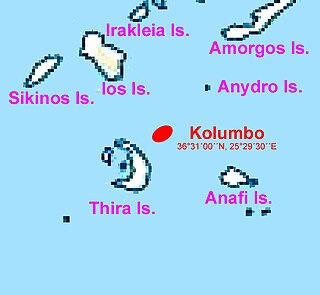
WKolumbo is an active submarine volcano in the Aegean Sea, about 8 km northeast of Cape Kolumbo, Santorini island. The largest of a line of about twenty submarine volcanic cones extending to the northeast from Santorini, it is about 3 km in diameter with a crater 1.5 km across. It was "discovered" when it breached the sea surface in 1649-50, but its explosion was not to be compared to the well-known Thera explosion and caldera collapse, currently dated ca. 1630 BCE, with its devastating consequences for Minoan civilization. The Smithsonian Institution's Global Volcanism Program treats it as part of the Santorini volcano.
WMonowai is a volcanic seamount to the north of New Zealand. It is formed by a large caldera and a volcanic cone just south-southeast from the caldera. The volcanic cone rises to depths of up to 100 metres (330 ft) but its depth varies with ongoing volcanic activity, including sector collapses and the growth of lava domes. The seamount and its volcanism were discovered after 1877, but only in 1980 was it named "Monowai" after a research ship of the same name.
 W
WMyōjin-shō (明神礁) is a submarine volcano located about 450 kilometers south of Tokyo on the Izu-Ogasawara Ridge in the Izu Islands. Volcanic activity has been detected there since 1869. Since then it has undergone more eruptions, the most powerful of which resulted in the appearance and disappearance of a small island.
 W
WPedro Bank is a large bank of sand and coral, partially covered with seagrass, about 80 km south and southwest of Jamaica, rising steeply from a seabed of 800 metres depth. It slopes gently from Pedro Cays to the west and north with depths from 13 to 30 metres. The total area of the bank within the 100-metre (328-foot) isobath measures 8,040 square kilometres. The area of a depth to 40 metres is triangular, 70 kilometres long east-west, and 43 kilometres wide. 2,400 square kilometres are less than 20 metres deep. With its islets, cays and rocks, a total land area of 270,000 m2 (2,906,256 sq ft), it is the location of one of the two offshore island groups of Jamaica, the other one being the Morant Cays. The bank is centered at 17°06′N 78°20′W.
 W
WProtector Shoal is a submarine volcano, also called seamount, which rises gently from an ocean depth of 3,900 feet (1,200 m) to about 55 metres (180 ft) below sea level approximately 31 miles (50 km) NW of Zavodovski Island in the South Sandwich Islands chain. The last eruption occurred during March 1962. Protector Shoal is the only volcano in the arc that has erupted rhyolite pumice.
 W
WSanta Rosae was, before the end of the last ice age, an ancient landmass off the coast of present-day southern California, near Santa Barbara County and Ventura County, of which the northern Channel Islands of California are remnants. At its largest, Santa Rosae was roughly 3-4 times bigger than the northern Channel Islands of today, nearly 125 km long from east to west. Between about 20,000 and 5,000 years ago, Santa Rosae lost about 70% of its land mass to post-glacial rising sea level, leaving behind a vast submerged landscape currently being explored by scientists. San Miguel, Santa Rosa, Santa Cruz, and Anacapa Island comprise the unsubmerged portions of Santa Rosae today. This island was about 5 miles offshore. It broke up between about 11,000 and 9,000 years ago, and the present northern Channel Islands took their shape after the continental ice sheets melted and sea levels rose by about 100 meters.
 W
WSchmieder Bank is a rocky bank west of Point Sur, California, roughly 25 nautical miles (46 km) south of Monterey, supporting an extraordinarily lush biological community, including very large individual colonies of the California hydrocoral, Stylaster californicus.
 W
WSupply Reef is a submerged circular reef of volcanic origin in the Northern Mariana Islands chain, about 10 kilometres (6 mi) NW of the Maug Islands. Presently this igneous seamount is roughly 8 metres (26 ft) below the ocean's surface and about 100 m (300 ft) in diameter. Apparent episodes of submarine volcanism were noted on December 22-24 and 26-27 in 1989.
 W
WUnnamed volcano (Ibugos), is a submarine volcano near the island Ibugos in the Philippines.
 W
WVema Seamount is a seamount in the South Atlantic Ocean. Discovered in 1959 by a ship with the same name, it lies 1,600 kilometres (1,000 mi) from Tristan da Cunha and 1,000 kilometres (620 mi) northwest of Cape Town. The seamount has a flat top at a mean depth of 73 metres which was eroded into the seamount at a time when sea levels were lower; the shallowest point lies at 26 metres depth. The seamount was formed between 15-11 million years ago, possibly by a hotspot.
 W
WThe Walters Shoals is a group of submerged mountains off the coast of Madagascar. The shoals are 845 kilometres (525 mi) south of Cape Sainte Marie - Madagascar and 1,210 kilometres (750 mi) east of Richards Bay at the African coast. The tips of some of the mountains are only 18 metres (59 ft) below the surface. The Walters Shoals is home to many species of fish, crustaceans, and mollusks. It was discovered in 1963 by the South African Hydrographic Frigate SAS Natal captained by Cmdr Walters. When found it had a huge population of Galápagos sharks but they have since been fished out.