 W
WThis is a list of Antarctic ice shelves.
 W
WThe Abbot Ice Shelf is an ice shelf 250 mi (400 km) long and 40 mi (60 km) wide, bordering Eights Coast from Cape Waite to Pfrogner Point in Antarctica. Thurston Island lies along the northern edge of the western half of this ice shelf; other sizable islands lie partly or wholly within this shelf.
 W
WThe Amery Ice Shelf is a broad ice shelf in Antarctica at the head of Prydz Bay between the Lars Christensen Coast and Ingrid Christensen Coast. It is part of Mac. Robertson Land. The name "Cape Amery" was applied to a coastal angle mapped on February 11, 1931, by the British Australian New Zealand Antarctic Research Expedition (BANZARE) under Douglas Mawson. He named it for William Bankes Amery, a civil servant who represented the United Kingdom government in Australia (1925–28). The Advisory Committee on Antarctic Names interpreted this feature to be a portion of an ice shelf and, in 1947, applied the name Amery to the whole shelf.
 W
WThe Bach Ice Shelf is an ice shelf which is irregular in shape and 45 miles (72 km) in extent, occupying an embayment in the south part of Alexander Island entered between Berlioz Point and Rossini Point. The ice shelf supports the south face of the Beethoven Peninsula, along with some minor extensive peninsulas and small inlets Bach ice shelf also supports the north side of the Monteverdi Peninsula. A minor embayment in this position first appeared on the charts of the US Antarctic Service, which explored the south part of Alexander Island by air and from the ground in 1940. The ice shelf was delineated by Derek J.H. Searle of the Falkland Islands Dependencies Survey in 1960, from air photos obtained by the Ronne Antarctic Research Expedition in 1947–48. It was named by the UK Antarctic Place-Names Committee after the German composer Johann Sebastian Bach.
 W
WThe Brunt Ice Shelf borders the Antarctic coast of Coats Land between Dawson-Lambton Glacier and Stancomb-Wills Glacier Tongue. It was named by the UK Antarctic Place-names Committee after David Brunt, British meteorologist, Physical Secretary of the Royal Society, 1948–57, who was responsible for the initiation of the Royal Society Expedition to this ice shelf in 1955.
 W
WDotson Ice Shelf is an ice shelf about 30 miles (50 km) wide between Martin Peninsula and Bear Peninsula on the coast of Marie Byrd Land in Antarctica. It was first mapped by the U.S. Geological Survey from air photos obtained by U.S. Navy Operation Highjump in January 1947, and was named by the Advisory Committee on Antarctic Names for Lieutenant William A. Dotson, US Navy, formerly Officer in Charge of the Ice Reconnaissance Unit of the Naval Oceanographic Office, killed in a plane crash in Alaska in November 1964 while on an ice reconnaissance mission.
 W
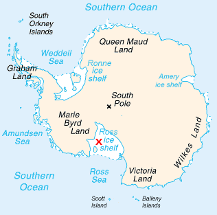
WThe Filchner-Ronne Ice Shelf, also known as Ronne-Filchner Ice Shelf, is an Antarctic ice shelf bordering the Weddell Sea.
 W
WThe George VI Ice Shelf is an extensive ice shelf that occupies George VI Sound which separates Alexander Island from Palmer Land in Antarctica. The ice shelf extends from Ronne Entrance, at the southwest end of the sound, to Niznik Island, about 30 nautical miles (56 km) south of the north entrance between Cape Brown and Cape Jeremy. It was named by the UK Antarctic Place-Names Committee in association with George VI Sound.
 W
WThe Getz Ice Shelf is the largest Antarctic ice shelf along the SE Pacific-Antarctic coastline, over 300 miles (500 km) long and from 20 to 60 miles wide, bordering the Hobbs and Bakutis Coasts of Marie Byrd Land between the McDonald Heights and Martin Peninsula. Several large islands are partially or wholly embedded in the ice shelf, pinning the calving front.
WJones Ice Shelf was the ice shelf occupying the Jones Channel, between the Arrowsmith Peninsula and Blaiklock Island, on the west coast of Graham Land, Antarctica. It was named by the UK Antarctic Place-Names Committee in 1981 in association with the channel.
WThe Larsen Ice Shelf is a long ice shelf in the northwest part of the Weddell Sea, extending along the east coast of the Antarctic Peninsula from Cape Longing to Smith Peninsula. It is named for Captain Carl Anton Larsen, the master of the Norwegian whaling vessel Jason, who sailed along the ice front as far as 68°10' South during December 1893. In finer detail, the Larsen Ice Shelf is a series of shelves that occupy distinct embayments along the coast. From north to south, the segments are called Larsen A, Larsen B, and Larsen C by researchers who work in the area. Further south, Larsen D and the much smaller Larsen E, F and G are also named.
 W
WThe McDonald Ice Rumples constitute an ice rise in the Brunt Ice Shelf bordering the Weddell Sea in Antarctica, covering an area of 3 by 2 nautical miles.
WMuller Ice Shelf, also known as Müller Ice Shelf according to the original German spelling of the family name Müller, was an ice shelf lying southwest of Hooke Point in southwest Lallemand Fjord, Arrowsmith Peninsula, Loubet Coast. It was nurtured by Brückner Glacier and Antevs Glacier.
WNansen Ice Sheet, or Nansen Ice Shelf, is a 30-mile-long (48 km) by 10-mile-wide (16 km) ice shelf. It is nourished by the Priestley and Reeves Glaciers and abutting the north side of the Drygalski Ice Tongue, along the coast of Victoria Land, Antarctica. This feature was explored by the South Magnetic Polar Party of the British Antarctic Expedition, 1907-09 and by the Northern Party of the British Antarctic Expedition, 1910-13. Frank Debenham, geologist with the latter expedition, applied the name Nansen Sheet as the feature is adjacent to Mount Nansen, the dominating summit in the area.ihay
WPrince Gustav Ice Shelf was an ice shelf of more than 15 nautical miles (28 km) extent occupying the south part of Prince Gustav Channel, including Rohss Bay, James Ross Island. Named by United Kingdom Antarctic Place-Names Committee (UK-APC) in 1990 in association with the channel. The ice shelf has since retreated and collapsed; in 1995 Prince Gustav Channel was open throughout its length, and only a remnant in Rohss Bay remained.
 W
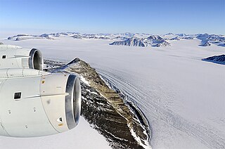
WThe Ross Ice Shelf is the largest ice shelf of Antarctica. It is several hundred metres thick. The nearly vertical ice front to the open sea is more than 600 kilometres (370 mi) long, and between 15 and 50 metres high above the water surface. Ninety percent of the floating ice, however, is below the water surface.
WShackleton Ice Shelf is an extensive ice shelf fronting the coast of East Antarctica from 95° E to 105° E. It extends for an along-shore distance of about 384 kilometres (239 mi), projecting seaward about 145 kilometres (90 mi) in the western portion and 64 kilometres (40 mi) in the east. It occupies an area of 33,820 square kilometres (13,058 sq mi). It is part of Mawson Sea and separates the Queen Mary Coast to the west from the Knox Coast of Wilkes Land to the east.
WStange Ice Shelf, is an Antarctic ice shelf in Stange Sound, English Coast, bounded to the east by Spaatz Island, to the northwest by Smyley Island, and to the west by fast ice in Carroll Inlet. Named in association with Stange Sound. In contrast to the some other ice shelves on the Antarctic Peninsula, for example the Larsen Ice Shelf, the Stange Ice Shelf has been relatively stable.
WSulzberger Bay is a bay between Fisher Island and Vollmer Island, along the coast of King Edward VII Land. Discovered by the Byrd Antarctic Expedition on December 5, 1929, and named by Byrd for Arthur H. Sulzberger, publisher of The New York Times, a supporter of the Byrd expeditions in 1928–1930 and 1933–1935.
 W
WThe Swinburne Ice Shelf, is an ice shelf just north of Edward VII Peninsula and the Alexandra Mountains in the southern part of Sulzberger Bay, Antarctica. The ice shelf is twenty miles (32 km) long and five miles (8 km) wide and extends from Fisher Island to White Islands. It was photographed from aircraft and mapped by the Byrd Antarctic Expedition (ByrdAE), 1928–30. Named by Advisory Committee on Antarctic Names (US-ACAN) for Captain H.W Swinburne, Jr., Deputy Commander and Chief of Staff, U.S. Naval Support Force, Antarctica, during Operation Deep Freeze 1970 and 1971.
 W
WThwaites Ice Shelf, is an Antarctic ice shelf in the Amundsen Sea. It was named by ACAN after Fredrik T. Thwaites, a glacial geologist and geomorphologist. The Thwaites Ice Shelf is one of the biggest ice shelves in West Antarctica, though it is highly unstable and disintegrating rapidly. Since the 1980s, the Thwaites glacier has had a net loss of over 600 billion tons of ice, though pinning of the Thwaites Ice Shelf has served to slow the process.
 W
WWilkins Sound is a seaway in Antarctica that is largely occupied by the Wilkins Ice Shelf. It is located on the southwest side of the Antarctic Peninsula between the concave western coastline of Alexander Island and the shores of Charcot Island and Latady Island farther to the west.
 W
WThe Wordie Ice Shelf was a confluent glacier projecting as an ice shelf into the SE part of Marguerite Bay between Cape Berteaux and Mount Edgell, along the western coast of Antarctic Peninsula.