 W
WAgia Anna is a village and a community in the municipal unit Nileas, in northern part of the island Euboea, Greece. The community includes the seaside village Agkali (Αγκάλι). At about 7 km, it has one of the longest beaches in Europe. It lies 12 km northeast of Limni and 47 km north of Chalkida. During winter, there are about 1000 inhabitants, with the number increasing highly during summer to around 7000 people. The commune is also famous for some of the best camping in Greece.
 W
WArtemisium or Artemision is a cape in northern Euboea, Greece. The legendary hollow cast bronze statue of Zeus, or possibly Poseidon, known as the Artemision Bronze, was found off this cape in a sunken ship, as was the Jockey of Artemision, a bronze statue of a racehorse and its jockey.
 W
WDirfi is a mountain in the central part of the island of Euboea, Greece. At 1,743 m elevation, it is the highest mountain of Euboea. The Dirfi gave its name to the municipal unit Dirfys. Its summit is 4 km west of Stropones, 5 km north of Steni Dirfyos and 28 km northeast of the city of Chalcis. There are forests on the lower slopes while most of the mountain is covered with grassland.
 W
WErinia, also Rineia is a Greek island in the Sporades located west of Skyros.
 W
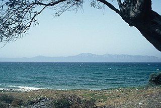
WEuboea or Evia is the second-largest Greek island in area and population, after Crete. It is separated from Boeotia in mainland Greece by the narrow Euripus Strait. In general outline it is a long and narrow island; it is about 180 km (110 mi) long, and varies in breadth from 50 km (31 mi) to 6 km (3.7 mi). Its geographic orientation is from northwest to southeast, and it is traversed throughout its length by a mountain range, which forms part of the chain that bounds Thessaly on the east, and is continued south of Euboea in the lofty islands of Andros, Tinos and Mykonos.
 W
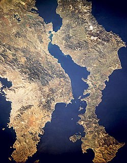
WThe Euripus Strait is a narrow channel of water separating the Greek island of Euboea in the Aegean Sea from Boeotia in mainland Greece. The strait's principal port is Chalcis on Euboea, located at the strait's narrowest point.
 W
WKantili is a mountain range in the northwestern part of the island of Euboea in Greece. Its maximum elevation is 1,246 m. It stretches along the west coast of the island, above the shore of the North Euboean Gulf, between Limni and Politika. Its length is about 25 km from southeast to northwest. The slope towards the sea is very steep, and there is no road along the coast. The Greek National Road 77 passes east of the mountains.
 W
WKavalliani is a small island in the South Euboean Gulf. It is located opposite of ancient Rhamnous in Attica. The island is still uninhabited although a building cooperative of Emporiki Bank is developed in the island. The island has an area about 2 km2. Administratively, the island belongs to Styra municipality.
 W
WThe Lelantine Plain is a fertile plain on the Greek island of Euboea, between Chalcis and Eretria. In the late eighth century BC a dispute over its possession was the cause of the Lelantine War. In the Middle Ages it was known as Lilanto; a Venetian document from 1439 describes a crisis caused by the powerful taking more than their share of the irrigation water: and so many plots have remained unirrigated, and if things continue like this, the place Lilanto, which is the life of this island, will turn into a desolation - a place which provides more utility to the Signoria than any other, through being the eye and garden of Euboea.
 W
WLichades or Lichadonisia is an island complex off the north west of Euboea, in the North Euboean Gulf. The islands located opposite Lichada cape in the north-western extreme of Euboea and opposite of small town Kamena Vourla in Central Greece mainland. Administratively, they belong to Istiaia-Aidipsos municipality, in Euboea regional unit.
 W
WThe Messapio is a small mountain range located in the northeastern part of Boeotia and the mainland part of Euboea regional unit in central Greece. It borders on the North Euboean Gulf and the Euripus Strait to the north and east. Its highest point is 1,021 m. It is 20 km long and 10 to 15 km wide and covers an area of 300 km². It separates the area around Chalcis from the Boeotian plains around Thebes. In the south, on the slope of the 740 m high mountain Ypato, there is the monastery of the Transfiguration of the Saviour. The nearest mountain ranges are the Ptoo to the northwest. The Motorway 1 passes south of the mountain.
WOchi is a mountain in the southeasternmost part of the island of Euboea, Greece. Its maximum elevation is 1,398 m. There are forests on the northern slopes while most of the mountain range is covered with grassland and bushes. It is 6 km northeast of the coastal town Karystos, 90 km southeast of the island capital Chalcis and 65 km east of Athens.
WMount Olympus is a mountain in the east central part of the island of Euboea, Greece. Its maximum elevation is 1,172 m. It is not the highest mountain of Euboea, that is 1,743 m high Dirfi, 16 km to the north. The Olympus is 10 km north of Amarynthos, 11 km northeast of Eretria and 24 km east of the city of Chalcis. There are forests on the northern slopes while most of the mountain range is covered with grassland and bushes.
 W
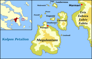
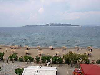
WPetalioi Greek: Πεταλιοί is an island complex in south-east of Euboea, in the homonymous gulf. It consists of 10 small islands and islets almost all uninhabited. The total area of the complex is 22.5 square kilometers. They belong to Karystos municipality, in Marmari municipal unit. The islands of the complex are: Megalonisos, Chersonisi, Avgo, Lamperousa, Louloudi, Makronisi, Pontikoniso, Praso, Tragos and Founti. The largest of them is Megalonisos. It has an area of 17 Km2 and is uninhabited. The most of them are private islands and belong to Greek shipowners.
WThe Petalioi Gulf is a gulf of the Aegean Sea, Greece. It stretches between the east coast of Attica and the south tip of the island Euboea. It takes its name from the Petalioi islands, that are situated in the northeastern part of the Gulf, off the Euboean coast. The Petalioi Gulf is connected to the South Euboean Gulf to the north. Its length is approximately 50 km long from north to south and its width is approximately 5 km in the north to about 50 km in the south. There are several uninhabited islands in the gulf, including the Petalioi and Makronisos. Promontories include Strongylo and Vigla in the island of Euboea.
WSarakino is a Greek island in the Sporades south of Skyros. As of 2011, it had no resident population.
WSkyropoula is a Greek island in the Sporades. The islet of Erinia lies directly to the east as well as the main island of Skyros. From 1860 until 2001, it was the private island of the Antoniadis family. This family has a long military and naval tradition; most recently, Admiral Antonis Antoniadis served as Chief of the Hellenic Navy General Staff from 2002 to 2005. In May 2001, the island became the property of an unidentified Cypriot businessman. As of 2011, it had no resident population.
 W
WSkyros is an island in Greece, the southernmost of the Sporades, an archipelago in the Aegean Sea. Around the 2nd millennium BC and slightly later, the island was known as The Island of the Magnetes where the Magnetes used to live and later Pelasgia and Dolopia and later Skyros. At 209 square kilometres (81 sq mi) it is the largest island of the Sporades, and has a population of about 3,000. It is part of the regional unit of Euboea.
 W
WThe South Euboean Gulf is a gulf in Central Greece, between the island of Euboea and the Greek mainland. With a total length of approximately 50 km and a width of 10 to 20 km, it stretches nearly diagonally from northwest to southeast, from the Euripus Strait, which connects it to the North Euboean Gulf, to the Petalies Gulf near Agia Marina in the south.
 W
WStouronisi or Styronisi is a small island in the Euboean Sea. It is located in the South Euboean Gulf opposite Styra. It is the largest island of a small island complex comprising 7 islets and rocks. The island has an area about 2 km2. Stouronisi has recently become known because of some plans of the Greek government for a development of a high-class summer resort in the island.
 W
WTelethrio is a small mountain range in the northwestern part of the island of Euboea, Greece. Its maximum elevation is 970 m. It stretches along the west coast of the island, on the North Euboean Gulf, from Aidipsos in the west to Rovies in the east. Its length is about 16 km from east to west. The mountain is forested. There are few villages on the steep southern slope, including Ilia. Villages on the northern slope are Taxiarchis, Kastaniotissa, Galatsades, Kamatriades and Simia.
 W
WTymfristos is a mountain in the eastern part of Evrytania and the western part of Phthiotis, Greece. The mountain is a part of the Pindus mountain range. The elevation of its highest peak, Velouchi, is 2,315 m. The nearest mountains are Kaliakouda and Panaitoliko to the south, Vardousia to the southeast and the Agrafa mountains to the north. It is drained by the river Spercheios to the east and by tributaries of the Acheloos to the west. The name Velouchi comes from Velos which means arrow, as Aetolian archers were known for harassing invading pre-Christian Celts and Persians with their famous archery. See The Greek and Macedonian Art of War, by F.E. Adcock, 1962.
 W
WValaxa is a Greek island in the Sporades. It is located southwest of the island Skyros, and is administratively a part of Skyros.