 W
WThe Little Kanawha River is a tributary of the Ohio River, 169 mi (269 km) long, in western West Virginia in the United States. Via the Ohio, it is part of the watershed of the Mississippi River, draining an area of 2,320 mi² (6,009 km²) on the unglaciated portion of the Allegheny Plateau. It served as an important commercial water route in the early history of West Virginia, particularly in the logging and petroleum industries.
 W
WBurnsville Lake is both a recreational and flood control reservoir on Little Kanawha River located southeast of Burnsville in Braxton County, West Virginia. Burnsville Lake was authorized by the U.S. Congress in the Flood Control Act of 1938.
 W
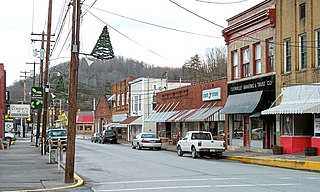
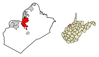
WBurnsville is a town in Braxton County, West Virginia, United States, at the confluence of the Little Kanawha River and Saltlick Creek. The population was 510 at the 2010 census. Burnsville was incorporated in 1902 by the Circuit Court and named for Captain John Burns who operated the first sawmill in that section of the state and who established the town shortly after the close of the American Civil War. It was named "All West Virginia City" in 1976.
 W
WCedar Creek is a tributary of the Little Kanawha River, 31.7 miles (51.0 km) long, in central West Virginia in the United States. Via the Little Kanawha and Ohio rivers, it is part of the watershed of the Mississippi River, draining an area of 81 square miles (210 km2) in a rural region on the unglaciated portion of the Allegheny Plateau.
 W
WElizabeth is a town in, and the county seat of Wirt County, West Virginia along the Little Kanawha River. The population was 823 as of the 2010 census.
 W
WGlenville is a town in and the county seat of Gilmer County, West Virginia, United States, along the Little Kanawha River. The population was 1,537 at the 2010 census. It is the home of Glenville State College.
 W
WGrantsville is a town in Calhoun County, West Virginia, in the United States. The population was 561 at the 2010 census. It is the county seat of Calhoun County. The town was established along the Little Kanawha River in 1865 and named for Ulysses S. Grant. Grantsville is home to Wayne Underwood Park, which includes a .25-mile-long (0.40 km) walking trail, and to the annual West Virginia Wood Festival.
 W
WThe Henry Fork is a tributary of the West Fork Little Kanawha River, 21.8 miles (35.1 km) long, in west-central West Virginia in the United States. Via the West Fork and the Little Kanawha and Ohio rivers, it is part of the watershed of the Mississippi River, draining an area of 91 square miles (240 km2) in a rural region on the unglaciated portion of the Allegheny Plateau.
 W
WThe Hughes River is a tributary of the Little Kanawha River in western West Virginia in the United States. Via the Little Kanawha and Ohio Rivers, it is part of the watershed of the Mississippi River. As measured from the confluence of its north and south forks, the Hughes is 18 mi (29 km) long, and drains a rural area of the unglaciated portion of the Allegheny Plateau.
 W
WLeading Creek is a tributary of the Little Kanawha River, 28.6 miles (46.0 km) long, in central West Virginia in the United States. Via the Little Kanawha and Ohio rivers, it is part of the watershed of the Mississippi River, draining an area of 147 square miles (380 km2) in a rural region on the unglaciated portion of the Allegheny Plateau.
 W
WPalestine is an unincorporated community in Wirt County, West Virginia, in the United States. It is located at the confluence of the Little Kanawha River and Reedy Creek, at 39°01′48″N 81°24′24″W, at an elevation of 682 feet. Its ZIP code is 26160. The community was named after Palestine.
 W
WParkersburg is a city in and the county seat of Wood County, West Virginia, United States. Located at the confluence of the Ohio and Little Kanawha rivers, it is the state's fourth-largest city and the largest city in the Parkersburg-Marietta-Vienna metropolitan area. The population was 31,492 at the 2010 census. Its peak population was 44,797 in 1960. The city is about 14 miles south of Marietta, Ohio.
 W
WReedy Creek is a tributary of the Little Kanawha River in western West Virginia in the United States. Via the Little Kanawha and Ohio rivers, it is part of the watershed of the Mississippi River, draining an area of 133 square miles (340 km2) in a rural region on the unglaciated portion of the Allegheny Plateau. It is 22.6 miles (36.4 km) long, or 38.5 miles (62.0 km) long including its Left Fork.
WThe Right Fork Little Kanawha River is a tributary of the Little Kanawha River, 14.1 miles (22.7 km) long, in central West Virginia in the United States. Via the Little Kanawha and Ohio rivers, it is part of the watershed of the Mississippi River, draining an area of 37.6 square miles (97 km2) in a rural region.
WSaltlick Creek is a tributary of the Little Kanawha River, 17.7 miles (28.5 km) long, located in central West Virginia in the United States. Via the Little Kanawha and Ohio rivers, it is part of the watershed of the Mississippi River, draining an area of 49 square miles (130 km2) in a rural region on the unglaciated portion of the Allegheny Plateau.
WThe Sand Fork is a tributary of the Little Kanawha River, 18.7 miles (30.1 km) long, in central West Virginia in the United States. Via the Little Kanawha and Ohio Rivers, it is part of the watershed of the Mississippi River, draining an area of 80 square miles (210 km2) in a rural region on the unglaciated portion of the Allegheny Plateau.
 W
WSand Fork is a town in Gilmer County, West Virginia, United States. The population was 159 at the 2010 census. It is located along the Little Kanawha River, at the mouth of the Sand Fork.
 W
WSpring Creek is a tributary of the Little Kanawha River in western West Virginia in the United States. Via the Little Kanawha and Ohio rivers, it is part of the watershed of the Mississippi River, draining an area of 89 square miles (230 km2) in a rural region on the unglaciated portion of the Allegheny Plateau. It is 25.3 miles (40.7 km) long, or 33.3 miles (53.6 km) long including its Left Fork.
WSteer Creek is a tributary of the Little Kanawha River in central West Virginia in the United States. Via the Little Kanawha and Ohio rivers, it is part of the watershed of the Mississippi River, draining an area of 184 square miles (480 km2) in a rural region on the unglaciated portion of the Allegheny Plateau. It is 6.3 miles (10.1 km) long, or 31.7 miles (51.0 km) long including its Right Fork.
 W
WTygart Creek is a tributary of the Little Kanawha River, 14.5 miles (23.3 km) long, in western West Virginia in the United States. Via the Little Kanawha and Ohio rivers, it is part of the watershed of the Mississippi River, draining an area of 51 square miles (130 km2) on the unglaciated portion of the Allegheny Plateau.
 W
WWalker Creek is a tributary of the Little Kanawha River, 15.6 miles (25.1 km) long, in western West Virginia in the United States. Via the Little Kanawha and Ohio rivers, it is part of the watershed of the Mississippi River, draining an area of 32 square miles (83 km2) on the unglaciated portion of the Allegheny Plateau.
 W
WThe West Fork Little Kanawha River is a tributary of the Little Kanawha River, 48.1 miles (77.4 km) long, in west-central West Virginia in the United States. Via the Little Kanawha and Ohio rivers, it is part of the watershed of the Mississippi River, draining an area of 246 square miles (640 km2) in a rural region on the unglaciated portion of the Allegheny Plateau. By drainage area, it is the second-largest tributary of the Little Kanawha River, after the Hughes River.
 W
WWorthington Creek is a tributary of the Little Kanawha River, 15.4 miles (24.8 km) long, in western West Virginia in the United States. Via the Little Kanawha and Ohio rivers, it is part of the watershed of the Mississippi River, draining an area of 35 square miles (91 km2) in the city of Parkersburg and its vicinity.