South African National Parks (SANParks) is the body responsible for managing South Africa's national parks. SANParks was formed in 1926, and currently manages 19 parks consisting of 3,751,113 hectares (37,511.13 km2), over 3% of the total area of South Africa.
 W
WAddo Elephant National Park is a diverse wildlife conservation park situated close to Port Elizabeth in South Africa and is one of the country's 20 national parks. It currently ranks third in size after Kruger National Park and the Kgalagadi Transfrontier Park.
 W
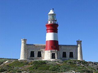
WThe Agulhas National Park is a South African national park located in the Agulhas Plain in the southern Overberg region of the Western Cape, about 200 kilometres (120 mi) south-east of Cape Town. The park stretches along the coastal plain between the towns of Gansbaai and Struisbaai, and includes the southern tip of Africa at Cape Agulhas. As of January 2009 it covered an area of 20,959 hectares. Although one of the smallest national parks in South Africa, it boasts 2,000 native plant species and a wetland that provides refuge to birds and amphibians.
 W
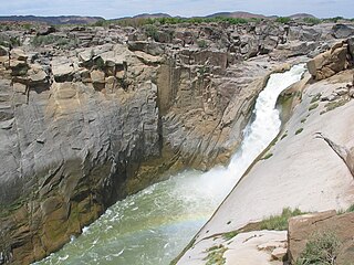
WAugrabies Falls National Park is a national park located around the Augrabies Falls, about 120 km west of Upington in the Northern Cape Province, South Africa. It was established in 1966.
 W
WBontebok National Park is a species-specific national park in South Africa. It was established in 1931 to ensure the preservation of the Bontebok. It is the smallest of South Africa's 18 National Parks, covering an area of 27.86 km2 The park is part of the Cape Floristic Region, which is a World Heritage Site.
 W
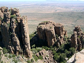
WThe Camdeboo National Park is located in the Karoo and almost completely surrounds the Eastern Cape town of Graaff-Reinet.
 W
WThe Garden Route National Park is a national park in the Garden Route region of the Western Cape and Eastern Cape provinces in South Africa. It is a coastal reserve well known for its indigenous forests, dramatic coastline, and the Otter Trail. It was established on 6 March 2009 by amalgamating the existing Tsitsikamma and Wilderness National Parks, the Knysna National Lake Area, and various other areas of state-owned land.
 W
WGolden Gate Highlands National Park is located in Free State, South Africa, near the Lesotho border. It covers an area of 340 km2 (130 sq mi). The park's most notable features are its golden, ochre, and orange-hued, deeply eroded sandstone cliffs and outcrops, especially the Brandwag rock. Another feature of the area is the numerous caves and shelters displaying San rock paintings. Wildlife featured at the park includes mongooses, eland, zebras, and over 100 bird species. It is the Free State's only national park, and is more famous for the beauty of its landscape than for its wildlife. Numerous paleontology finds have been made in the park, including dinosaur eggs and skeletons.
 W
WThe Karoo National Park, founded in 1979, is a wildlife reserve in the Great Karoo area of the Western Cape, South Africa near Beaufort West. This semi-desert area covers an area of 750 square kilometres (290 sq mi). The Nuweveld portion of the Great Escarpment runs through the Park. It is therefore partly in the Lower Karoo, at about 850 m above sea level, and partly in the Upper Karoo at over 1300 m altitude.
 W
WKgalagadi Transfrontier Park is a large wildlife preserve and conservation area in southern Africa. The park straddles the border between South Africa and Botswana and comprises two adjoining national parks:Kalahari Gemsbok National Park in South Africa Gemsbok National Park in Botswana
 W
WKruger National Park is a South African National Park and one of the largest game reserves in Africa. It covers an area of 19,485 km2 (7,523 sq mi) in the provinces of Limpopo and Mpumalanga in northeastern South Africa, and extends 360 km (220 mi) from north to south and 65 km (40 mi) from east to west. The administrative headquarters are in Skukuza. Areas of the park were first protected by the government of the South African Republic in 1898, and it became South Africa's first national park in 1926.
 W
WMapungubwe National Park is a national park in Limpopo Province, South Africa. It is located by the Kolope River, south of the confluence of the Limpopo and Shashe rivers and about 15 kilometres (9.3 mi) to the NE of the Venetia Diamond Mine. The National Park borders Mapesu Private Game Reserve to the south. It abuts on the border with Botswana and Zimbabwe, and forms part of the Greater Mapungubwe Transfrontier Conservation Area. It was established in 1995 and covers an area of over 28,000 hectares. The park protects the historical site of Mapungubwe Hill, which was the capital of the Kingdom of Mapungubwe, as well as the wildlife and riverine forests along the Limpopo River. The Mapungubwe Hill was the site of a community dating back to the Iron Age. Evidences have shown that it was a prosperous community. Archaeologists also uncovered the famous golden rhino figurine from the site. It is one of the few places in Africa that has both meerkats and Nile crocodiles.
 W
WMarakele National Park is a National Park that is part of the Waterberg Biosphere in Limpopo Province, South Africa.
 W
WMokala National Park is a reserve established in the Plooysburg area south-west of Kimberley in the Northern Cape, South Africa on 19 June 2007. The size of the park is 26,485 hectares. Mokala is the Setswana name for the magnificent camel thorn, a tree species typical of the arid western interior and common in the area. There is currently 70 km of accessible roads in the national park.
 W
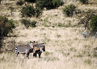
WMountain Zebra National Park is a national park in the Eastern Cape province of South Africa proclaimed in July 1937 for the purpose of providing a nature reserve for the endangered Cape mountain zebra.
 W
WNamaqua National Park is a South African national park situated approximately 495 km north of Cape Town and 22 km northwest of Kamieskroon. It has an area of more than 1300 km2. The park is part of Namaqualand, an area covering 55,000 km2 located within the semi-desert Succulent Karoo biome. This biome is a biodiversity hotspot with the largest concentration of succulent plants in the world. The park also has an arid environment with succulent plants. The park was created to protect its flowers. During the spring, wildflowers bloom there in a spectacular fashion. The park's main tourist attraction is this abundant spring bloom of brightly coloured wildflowers.
 W
WThe Richtersveld is a desert landscape characterised by rugged kloofs and high mountains, situated in the north-western corner of South Africa’s Northern Cape province. It is full of changing scenery from flat, sandy, coastal plains, to craggy sharp mountains of volcanic rock and the lushness of the Orange River, which forms the border with neighboring Namibia. The area ranges in altitude from sea level, to 1,377 m (4,518 ft) at Cornellberg. Located in the north-eastern side of the Northern Cape province in South Africa, the Richtersveld is regarded as the only arid biodiversity hotspot on earth and the majority of the area is inscribed on UNESCO's World Heritage List due to its cultural values.
 W
WThe 80.94 squarekilometer sized Royal Natal National Park is in the KwaZulu-Natal province of South Africa and forms part of the uKhahlamba Drakensberg Park World Heritage Site. Notwithstanding the name, it is actually not a South African National Park managed by the SANParks, but rather a Provincial Park managed by Ezemvelo KZN Wildlife. This park is now included into the Maloti-Drakensberg Transfrontier Conservation Area Peace Park.
 W
WSodwana Bay National Park, is situated on the Sodwana Bay coast within the iSimangaliso Wetland Park, in the KwaZulu-Natal, province of South Africa. In summer, loggerhead and leatherback turtles come out of the sea to nest on the beaches.
 W
WTankwa Karoo National Park is a national park in South Africa. The park lies about 70 km due west of Sutherland near the border of the Northern Cape and Western Cape, in one of the most arid regions of South Africa, with areas receiving less than 100 mm of average annual precipitation, moisture-bearing clouds from the Atlantic Ocean being largely stopped by the Cederberg mountains. Other low areas receive little more, as the Roodewerf station with 180 mm of mean annual rainfall. In the hottest areas of the park, the mean maximum temperature in January is 38.9 °C, and in July the mean minimum temperature ranges from about 5 to 7 °C. Before this Park's proclamation, the only protected area of Succulent Karoo was the 2 square kilometre patch of the Gamkaberg Nature Reserve. Succulent Karoo has, together with the Cape Floral Kingdom, been declared a Biodiversity Hotspot by Conservation International.
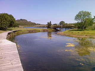
WThe Tsitsikamma National Park is a protected area on the Garden Route, Western Cape and Eastern Cape, South Africa. It is a coastal reserve well known for its indigenous forests, dramatic coastline, and the Otter Trail. On 6 March 2009 it was amalgamated with the Wilderness National Park and various other areas of land to form the Garden Route National Park.
 W
WThe West Coast National Park lies 120 km (75 mi) north of Cape Town in the Western Cape province of South Africa. It is 36,259.8 hectares (140.000 sq mi) in size. It is bordered by the Atlantic Ocean on the west and the R27 coastal road, and runs from the town of Yzerfontein in the south up to the Langebaan Lagoon. The park was proclaimed in 1985. The park is particularly well known for its bird life and for the spring flowers which occur in the months from August to September, especially in the Postberg flower reserve section of the park. The park, with the islands in Saldanha Bay, has been identified by BirdLife International as an Important Bird Area.
 W
WWilderness National Park, also called the Wilderness Section, is located around the seaside town of Wilderness between the larger towns of George and Knysna, in the Western Cape. It is a protected area of South Africa forming part of the Garden Route National Park.