 W
WDiamond Head is a volcanic tuff cone on the Hawaiian island of Oʻahu and known to Hawaiians as Lēʻahi. The Hawaiian name is most likely derived from lae plus ʻahi (tuna) because the shape of the ridgeline resembles the shape of a tuna's dorsal fin. Its English name was given by British sailors in the 19th century, who mistook calcite crystals on the adjacent beach for diamonds.
 W
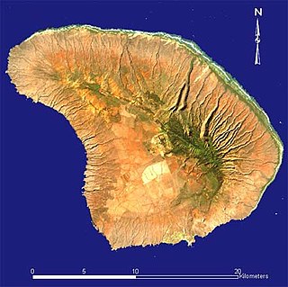
WThe East Molokai Volcano, sometimes also known as Wailau for the Wailau valley on its north side, is an extinct shield volcano comprising the eastern two-thirds of the island of Molokaʻi in the U.S. state of Hawaii.
 W
WThe fifteen volcanoes that make up the eight principal islands of Hawaii are the youngest in a chain of more than 129 volcanoes that stretch 5,800 kilometres (3,600 mi) across the North Pacific Ocean, called the Hawaiian–Emperor seamount chain. Hawaiʻi's volcanoes rise an average of 4,600 metres (15,000 ft) to reach sea level from their base. The largest, Mauna Loa, is 4,169 metres (13,678 ft) high. As shield volcanoes, they are built by accumulated lava flows, growing a few meters or feet at a time to form a broad and gently sloping shape.
 W
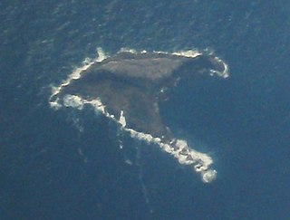
WGannet Island is a small island some 19 kilometres offshore from Kawhia on the west coast of New Zealand's North Island.
 W
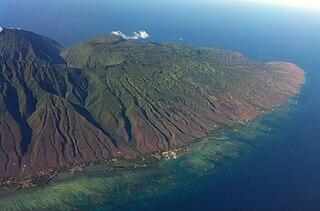
WHaleakalā, or the East Maui Volcano, is a massive shield volcano that forms more than 75% of the Hawaiian Island of Maui. The western 25% of the island is formed by another volcano, Mauna Kahalawai, also referred to as the West Maui Mountains.
 W
WHualālai is an active volcano on the island of Hawaiʻi in the Hawaiian Islands. It is the westernmost, third-youngest and the third-most active of the five volcanoes that form the island of Hawaiʻi, following Kīlauea and the much larger Mauna Loa. Its peak stands 8,271 feet (2,521 m) above sea level. Hualālai is estimated to have risen above sea level about 300,000 years ago. Despite maintaining a very low level of activity since its last eruption in 1801, and being unusually inactive for the last 2,000 years, Hualālai is still considered active, and is expected to erupt again some time within the next century. The relative unpreparedness of the residents in the area caused by the lull in activity would worsen the consequences of such an event.
 W
WKahoʻolawe anglicized as Kahoolawe is the smallest of the eight main volcanic islands in the Hawaiian Islands. Kahoʻolawe is located about seven miles (11 km) southwest of Maui and also southeast of Lānaʻi, and it is 11 mi (18 km) long by 6.0 mi (9.7 km) wide, with a total land area of 44.97 sq mi (116.47 km2). The highest point on Kahoʻolawe is the crater of Lua Makika at the summit of Puʻu Moaulanui, which is about 1,477 feet (450 m) above sea level. Kahoʻolawe is relatively dry because the island's low elevation fails to generate much orographic precipitation from the northeastern trade winds, and Kahoʻolawe is located in the rain shadow of eastern Maui's 10,023-foot-high (3,055 m) volcano, Haleakalā. More than one quarter of Kahoʻolawe has been eroded down to saprolitic hardpan soil, largely on exposed surfaces near the summit.
 W
WKamakou is the highest peak on the island of Molokai, at 4,961 feet (1,512 m). It is part of the extinct East Molokai shield volcano, which comprises the east side of the island. Kamakou is located within the 2,774 acres Molokai Forest Reserve, estimated to contain more than 250 rare native Hawaiian plants, many of which exist only in this part of the world. Rare birds can also be found, with two examples being the olomaʻo and kākāwahie. Monthly tours are held by The Nature Conservancy.
 W
WKohala is the oldest of five volcanoes that make up the island of Hawaii. Kohala is an estimated one million years old—so old that it experienced, and recorded, the reversal of earth's magnetic field 780,000 years ago. It is believed to have breached sea level more than 500,000 years ago and to have last erupted 120,000 years ago. Kohala is 606 km2 (234 sq mi) in area and 14,000 km3 (3,400 cu mi) in volume, and thus constitutes just under 6% of the island of Hawaii.
 W
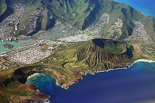
WKoko Head is the headland that defines the eastern side of Maunalua Bay along the southeastern side of the Island of Oahu in Hawaii. On its western slope is the community of Portlock, a part of Hawaiʻi Kai. Koko Head is an ancient tuff cone that is somewhat dwarfed by its neighboring tuff cone, Koko Crater, with its peak, Kohelepelepe, rising to 1208 ft or 368 m. Koko Head itself has three significant depressions or old vents, the largest of which forms the well-known Hanauma Bay. Koko Head's last eruption was 30,000–35,000 years ago and it is part of the Honolulu Volcanics.
 W
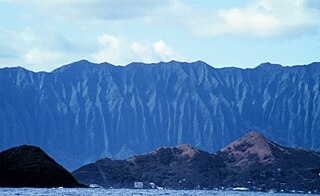
WKoʻolau Range is a name given to the dormant fragmented remnant of the eastern or windward shield volcano of the Hawaiian island of Oʻahu. It was designated a National Natural Landmark in 1972.
 W
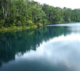
WLake Eacham is a popular lake of volcanic origin on the Atherton Tableland of Queensland, Australia, within the World Heritage listed Wet Tropics of Queensland. It is within the locality of Lake Eacham in the Tablelands Region local government area.
 W
WLanai is the sixth-largest of the Hawaiian Islands and the smallest publicly accessible inhabited island in the chain. It is colloquially known as the Pineapple Island because of its past as an island-wide pineapple plantation. The island's only settlement of note is the small town of Lanai City. As of 2012, the island was 98% owned by Larry Ellison, with the remaining 2% owned by the state of Hawaii and privately owned homes.
 W
WMāhukona is a submerged shield volcano on the northwestern flank of the Island of Hawaiʻi. A drowned coral reef at about 3,770 feet below sea level and a major break in slope at about 4,400 feet below sea level represent old shorelines. The summit of the shield volcano was once 800 feet above sea level. It has now subsided below sea level. A roughly circular caldera marks the summit of Māhukona. A prominent rift zone extends to the west. A second rift zone probably extended to the east but has been buried by younger volcanoes. The main shield-building stage of volcanism ended about 470,000 years ago. The summit of the shield volcano subsided below sea level between 435,000 and 365,000 years ago. This makes Māhukona the oldest volcano to build Hawaiʻi island, compared to Kohala to the east and Mauna Kea to the east. The Monterey Bay Aquarium Research Institute investigated the area with a remotely controlled submarine in 2001.
 W
WMauna Kea is a dormant volcano on the island of Hawaiʻi. Its peak is 4,207.3 m (13,803 ft) above sea level, making it the highest point in the state of Hawaiʻi. Most of the volcano is underwater, and when measured from its underwater base, Mauna Kea is the tallest mountain in the world, measuring 10,211 m (33,500 ft) in height. Mauna Kea is about a million years old, and has thus passed the most active shield stage of life hundreds of thousands of years ago. In its current post-shield state, its lava is more viscous, resulting in a steeper profile. Late volcanism has also given it a much rougher appearance than its neighboring volcanoes due to construction of cinder cones, decentralization of its rift zones, glaciation on its peak, and weathering by the prevailing trade winds. Mauna Kea last erupted 6,000 to 4,000 years ago and is now considered dormant. The peak is about 38 m (125 ft) higher than Mauna Loa, its more massive neighbor.
 W
WMauna Loa is one of five volcanoes that form the Island of Hawaii in the U.S. state of Hawaiʻi in the Pacific Ocean. The largest subaerial volcano in both mass and volume, Mauna Loa has historically been considered the largest volcano on Earth, dwarfed only by Tamu Massif. It is an active shield volcano with relatively gentle slopes, with a volume estimated at approximately 18,000 cubic miles (75,000 km3), although its peak is about 125 feet (38 m) lower than that of its neighbor, Mauna Kea. Lava eruptions from Mauna Loa are silica-poor and very fluid, and they tend to be non-explosive.
 W
WMolokini is a crescent-shaped, partially submerged volcanic crater which forms a small, uninhabited islet located in ʻAlalākeiki Channel between the islands of Maui and Kahoʻolawe, within Maui County in Hawaiʻi. It is the remains of one of the seven Pleistocene epoch volcanoes that formed the prehistoric Maui Nui island, during the Quaternary Period of the Cenozoic Era.
 W
WMount Taranaki / Mount Egmont is a dormant stratovolcano in the Taranaki region on the west coast of New Zealand's North Island. Although the mountain is more commonly referred to as Taranaki, it has two official names under the alternative names policy of the New Zealand Geographic Board. The 2518-metre (8260-foot) mountain has a secondary cone, Fanthams Peak, 1,966 metres (6,450 ft), on its south side. Because of its resemblance to Mount Fuji, Taranaki provided the backdrop for the 2003 film The Last Samurai.
 W
WOlokui is the second highest peak on the island of Molokai, surpassed by only Kamakou. At 4,602 feet (1,403 m), it marks the divide between the Pelekunu and Wailau valleys. It is part of the extinct East Molokai shield volcano, which comprises the east side of the island. On the west it is bounded by the Kapapa Pali, and on the south and east sides, there is a steep drop down to the Pulena stream and Wailau River, respectively. The north side of the mountain was destroyed in a catastrophic collapse along with the majority of the northern half of the island 1.4 million years ago. The remnants of this event are 3,200 foot sea cliffs. At the summit of Olokui, much like the tops of other high mountains in Hawaii, is a remote bog. The name Olokui translates to "tall hill", and according to oral tradition, was the place the people of the village of Pelekunu retreated to in a battle between islands.
 W
WPenguin Bank is the name given to a now-submerged shield volcano of the Hawaiian Islands. Its coral-capped remains lie immediately west of the island of Molokaʻi, under relatively shallow water.
 W
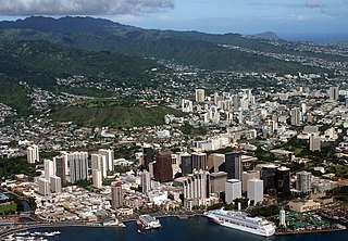
WPunchbowl Crater is an extinct volcanic tuff cone located in Honolulu, Hawaii. It is the location of the National Memorial Cemetery of the Pacific.
 W
WMount Tantalus (Puu-ohia) is an extinct cinder cone in the southern Koʻolau Range on the Hawaiian Island of Oʻahu. It also has a summit crater, Tantalus Crater. The cinder cone formed after the demise of Koʻolau Volcano, during a time of rejuvenated-stage volcanism in southeastern Oʻahu that also formed Punchbowl Crater, Diamond Head and Koko Head as part of the Honolulu Volcanics. Tantalus overlooks the modern city of Honolulu, which is built on top of Tantalus cinders.
 W
WThe West Maui Mountains, West Maui Volcano, or Mauna Kahalawai which means "holding house of water," is approximately 1.7 million years old and forms a much eroded shield volcano that constitutes the western quarter of the Hawaiian Island of Maui. Since its last eruption approximately 320,000 years ago, the West Maui Mountains have undergone substantial stream erosion.