 W
WThis list of earthquakes in Greece includes notable earthquakes that have affected Greece during recorded history. This list is currently incomplete, representing only a fraction of the possible events.
 W
WThe Rhodes earthquake of 226 BC, which affected the island of Rhodes, Greece, is famous for having toppled the large statue known as the Colossus of Rhodes. Following the earthquake, the statue lay in place for nearly eight centuries before being sold off by invaders. While 226 BC is most often cited as the date of the quake, sources variously cite 226 or 227 BC as dates when it occurred.
WThe 1481 Rhodes earthquake occurred at 3:00 in the morning on 3 May. It triggered a small tsunami, which caused local flooding. There were an estimated 30,000 casualties. It was the largest of a series of earthquakes that affected Rhodes, starting on 15 March 1481, continuing until January 1482.
WThe 1810 Crete earthquake occurred at 22:15 on 16 February. It caused great destruction in Heraklion, some damage from Malta to northern Egypt and was felt from central Italy to Syria. 2,000 fatalities were reported from Candia (Heraklion).
WThe 1881 Chios earthquake occurred at 13:40 local time on 3 April. It caused severe damage on the island of Chios and also affected Çeşme and Alaçatı on the coast of Turkey. The earthquake had an estimated magnitude of 7.3 and there were an estimated 7,866 casualties. The devastation from the earthquake was the last of the three 'catastrophes' that affected the island of Chios in the 19th century.
WThe 1886 Peloponnese earthquake occurred at 23:27 local time on 27 August. It had an estimated magnitude between 6.8 and 7.3 on the moment magnitude scale and a maximum felt intensity of X (Extreme) on the Mercalli intensity scale. It caused extensive damage in Messenia, with the towns of Filiatra and Marathos both severely affected. Between 326 and 600 people were killed. It was felt over a wide area from the Khedivate of Egypt to Malta and possibly as far away as Bern and Marseille.
WThe first of the 1894 Atalanti earthquakes occurred on 20 April 1894 at 16:52 UTC, with a magnitude of 6.4 on the moment magnitude scale and a maximum perceived intensity of X on the Mercalli intensity scale. It was followed seven days later on 27 April at 19:42 UTC by the second, with a magnitude of 6.9 and a maximum intensity of X. These two earthquakes caused widespread damage in the Locris area, causing a total of 255 deaths. More literature on these destructive events can be seen in the references section.
WThe 1904 Samos earthquake struck Greece on August 11 with moment magnitude of 6.8 and a maximum Mercalli intensity of X (Extreme). Four people were killed.
WThe 1932 Ierissos earthquake occurred at 19:20 on 26 September. It caused severe damage in Ierissos and the surrounding part of the Chalkidiki peninsula, with 491 casualties reported.
WThe 1953 Ionian earthquake struck the southern Ionian Islands in Greece on August 12. In mid-August there were over 113 recorded earthquakes in the region between Kefalonia and Zakynthos, and the most destructive was the August 12 earthquake. The event measured 6.8 on the moment magnitude scale, raised the whole island of Kefalonia by 60 cm (24 in), and caused widespread damage throughout the islands of Kefalonia and Zakynthos. The maximum felt intensity of shaking was X (extreme) on the Mercalli intensity scale. Between 445 and 800 people were killed.
WThe 1956 Amorgos earthquake occurred at 03:11 UTC on July 9. It had a magnitude of 7.7 on the moment magnitude scale and a maximum perceived intensity of IX on the Mercalli intensity scale. The epicentre was to the south of the island of Amorgos, the easternmost island of the Cyclades in the Aegean Sea. There was significant damage on Amorgos and the neighbouring island of Santorini. It was the largest earthquake in Greece in the 20th century. It was followed 13 minutes later by a magnitude 7.2 earthquake near Santorini. It triggered a major tsunami with a maximum run-up of 30 m. The combined effects of the earthquake shaking and the tsunami caused the deaths of 53 people with a further 100 injured.
WThe 1978 Thessaloniki earthquake occurred on 20 June at 23:03 local time. The shock registered 6.5 on the moment magnitude scale, had a maximum Mercalli intensity of VIII (Severe), and was felt throughout northern Greece, Yugoslavia and Bulgaria. It was the largest event in the area since the 1932 Ierissos earthquake.
 W
WIn early 1981 the eastern Gulf of Corinth, Greece was struck by three earthquakes with a magnitude greater than 6 Ms over a period of 11 days. The earthquake sequence caused widespread damage in the Corinth–Athens area, destroying nearly 8,000 houses and causing 20–22 deaths.
WThe 1999 Athens earthquake occurred on September 7 at 14:56:51 local time near Mount Parnitha in Greece with a moment magnitude of 6.0 and a maximum Mercalli intensity of IX (Violent). The proximity to the Athens metropolitan area resulted in widespread structural damage, mainly to the nearby suburbs of Ano Liossia, Acharnes, Fyli, Thrakomakedones, Kifissia, Metamorfosi, Kamatero and Nea Philadelphia. More than 100 buildings across those areas collapsed trapping scores of victims under their rubble while dozens more were severely damaged. With damage estimated at $3–4.2 billion, 143 people were killed, and up to 1,600 were treated for injuries in Greece's deadliest natural disaster in almost half a century.
WThe 2006 Greece earthquake – also known as the Kythira earthquake – occurred on January 8 at 13:34:53 local time and was felt throughout the entire eastern Mediterranean basin. The earthquake an Mw magnitude 6.7 and a maximum Mercalli intensity of VII. Its epicentre was located just off the island of Kythira about 200 kilometres (120 mi) south of Athens.
WThe 2008 Dodecanese earthquake occurred near Kattavia on the island of Rhodes in the eastern Mediterranean Sea on 15 July. The quake struck at 06:26 a.m. local time (UTC+3) and one woman was killed when she slipped and fell as she tried to flee her home. However, the earthquake did not cause any major damage. The earthquake was felt across the entire eastern Mediterranean, as far west as Libya, and inland as far as Damascus.
WThe 2008 Peloponnese earthquake killed two people, injured more than 220 and left at least 2,000 people homeless in north western Peloponnese, Greece, on June 8. The earthquake hit the area at 1525 EET, with a moment magnitude of 6.5, according to the Athens Geodynamic Institute. It was strongly felt as far away as in Athens and in parts of southern Italy. The US Geological Survey reported that the quake had a magnitude of 6.4. The epicenter of the tremor was located about 15 miles (32 km) southwest of the Greek port city of Patras, at a depth of 16 km. Interior Minister Prokopis Pavlopoulos dispatched rescue and recovery teams, the Red Cross and units of the army in order to assess the damage and the needs of survivors in the earthquake affected areas.
WAn earthquake occurred in the northern Aegean Sea between Greece and Turkey on May 24, 2014. It had a moment magnitude of 6.9 and a maximum Mercalli intensity of VIII (Severe). Serious damage was reported on the Turkish island of Imbros and the cities of Edirne and Çanakkale, as well as on the Greek island of Lemnos. The earthquake was felt in Bulgaria and southern Romania. Several aftershocks followed the main shock, the strongest measuring 5.3 ML. This aftershock struck the Gulf of Saros at 12:31 local time.
 W
WThe 2017 Lesbos earthquake occurred at 12:28:39 UTC on 12 June. The earthquake's epicentre was 5 km south of Plomari on the Greek island of Lesbos off the Aegean coast of Turkey. It had a magnitude of 6.3 on the moment magnitude scale and a maximum perceived intensity of IX (Violent) on the Mercalli intensity scale. Extensive damage was caused on parts of southern Lesbos, where there was one fatality and 10 people were injured. The earthquake was also felt in Turkey but no significant damage or injuries were reported.
 W
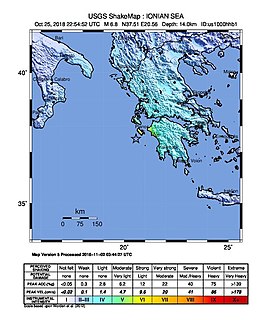
WA strong earthquake measuring magnitude Mw 6.8 occurred in the Ionian Sea near the coasts of Greece during the night between 25 and 26 October 2018 at 22:54:51 UTC. Sea level changes were predicted, and a tsunami advisory was issued. Reports of sea level change of up to 20 centimeters were reported in Greece and Italy.
 W
WA magnitude 7.0 earthquake struck on Friday, 30 October 2020, about 14 km (8.7 mi) northeast of the Greek island of Samos. Many buildings were damaged or collapsed as a result of the earthquake, with the Church the Assumption of Mary in Karlovasi, Greece, partially collapsing, while in the Turkish city İzmir, which was heavily affected by the earthquake, dozens of buildings were either damaged or completely collapsed. Emergency services in both countries immediately attended the scene, as rescue efforts continued into the night.
WThe 426 BC Malian Gulf tsunami devastated the coasts of the Malian and Euboean Gulfs, Greece, in the summer of 426 BC. Thucydides inquired into its causes, and concluded that the tsunami must have been caused by an earthquake. He was thus historically the first known to correctly interpret the cause of a tsunami as a preceding geological event. Herodotus, in contrast, had attributed the Potidaea tsunami to the divine wrath of Poseidon.
WThe 464 BCE Sparta earthquake occurred along the Sparta fault in the year 464 BCE destroying much of what was Sparta and many other City-states in Ancient Greece. Historical sources suggest that the death toll may have been as high as 20,000, although modern scholars suggest that this figure is likely an exaggeration. The earthquake gave the helots an opportunity to revolt against the Spartans, and the Athenians were called to their aid. Their immediate dismissal upon arrival is said to have been a key event that lead up to the First Peloponnesian War.
WA magnitude 6.6 earthquake struck on 21 July 2017, about 10 km (6.2 mi) south southeast of Bodrum, Turkey, at depth of 7.0 km. Two people were killed and more than 120 others were injured on the Greek island of Kos, while at least 360 injuries were reported in Turkey.