 W
WThe Cathedral Range is a mountain range immediately to the south of Tuolumne Meadows in Yosemite National Park. The range is an offshoot of the Sierra Nevada. The range is named after Cathedral Peak, which resembles a cathedral spire.
 W
WThe Clark Range is a subrange of California's Sierra Nevada in Yosemite National Park.
 W
WThe Dana Meadows can be found at the eastern entrance to Yosemite National Park, at the foot of Mount Dana, not far from Tuolumne Meadows and the Tioga Pass entrance station.
 W
WDonohue Pass is a high mountain pass on the boundary between Yosemite National Park and the Ansel Adams Wilderness. Its elevation is 11,066 feet (3,373 m). It is situated between Mount Lyell and Donohue Peak. The John Muir Trail and the Pacific Crest Trail both transverse the pass. Following the John Muir Trail, the pass is 6.3 miles (10.1 km) from Thousand Island Lake, and 12.8 miles (20.6 km) from Tuolumne Meadows. Donohue Pass is the sixth highest pass of the ten named passes on the John Muir Trail.
 W
WGlacier Point is a viewpoint above Yosemite Valley in the U.S. state of California. It is located on the south wall of Yosemite Valley at an elevation of 7,214 feet (2,199 m), 3,200 feet (980 m) above Half Dome Village. The point offers a superb view of several of Yosemite National Park's well-known landmarks, including Yosemite Valley, Yosemite Falls, Half Dome, Vernal Fall, Nevada Fall, and Clouds Rest. Between 1872 and 1968, it was the site of the Yosemite Firefall.
 W
WThe Grand Canyon of the Tuolumne is the notable canyon section of the river valley of the Tuolumne River, located within Yosemite National Park, in Tuolumne County and the Sierra Nevada, California.
 W
WMany granite domes are in Yosemite National Park.
 W
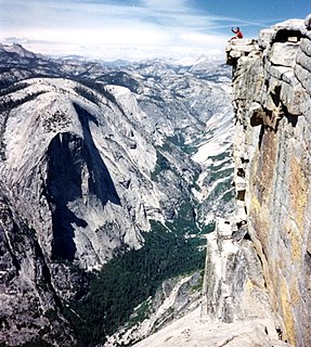
WHalf Dome is a granite dome at the eastern end of Yosemite Valley in Yosemite National Park, California. It is a well-known rock formation in the park, named for its distinct shape. One side is a sheer face while the other three sides are smooth and round, making it appear like a dome cut in half. The granite crest rises more than 4,737 ft (1,444 m) above the valley floor.
 W
WHappy Isles is a group of small isles in the Merced River in Yosemite National Park, California, USA. They are located at the easternmost end of the Yosemite Valley floor. This scenic spot is the starting point for the Mist Trail, and is also the northern trailhead for the John Muir Trail. Happy Isles is also the trailhead for popular hiking destinations along the Mist Trail and Half Dome.
 W
WHetch Hetchy is the name of a valley, a reservoir and a water system in California in the United States. The glacial Hetch Hetchy Valley lies in the northwestern part of Yosemite National Park and is drained by the Tuolumne River. For thousands of years before the arrival of settlers from the United States in the 1850s, the valley was inhabited by Native Americans who practiced subsistence hunting-gathering. During the late 19th century, the valley was renowned for its natural beauty – often compared to that of Yosemite Valley – but also targeted for the development of water supply for irrigation and municipal interests.
 W
WLittle Yosemite Valley is a smaller glacial valley upstream in the Merced River drainage from the Yosemite Valley in Yosemite National Park. The Merced River meanders through the 3.5 mi (5.6 km) long flat valley, draining out over Nevada Fall and Vernal Fall before emptying into the main Yosemite Valley. It can be reached by a day hike from the main valley, and is the most popular area in the Yosemite Wilderness. The Valley provides access to nearby destinations such as the back side of Half Dome, Clouds Rest and the High Sierra Camp at Merced Lake.
 W
WLyell Canyon is a sub-alpine meadow in Yosemite National Park south of Tuolumne Meadows. For 13 kilometers most of the canyon has an approximate elevation of 2 700 meters, and then rapidly climbs to 3 370 meters to Donohue Pass, below Donohue Peak – which marks the eastern boundary of Yosemite. The valley at the base is relatively flat and wide, following the Lyell Fork of the Tuolumne River through an open meadow and wooded areas. The Lyell Fork eventually meets with Tuolumne River.
 W
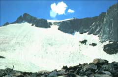
WLyell Glacier is in the Sierra Nevada of California. The glacier was discovered by John Muir in 1871, and was the largest glacier in Yosemite National Park. It lies on the northern slopes of Mount Lyell.
 W
WLyell Meadow is a meadow, in the region of Tuolumne Meadows, in Yosemite National Park.
 W
WMcGurk Meadow is a meadow in Yosemite National Park located near Bridalveil Fall. It is located at 37°40′48″N 119°37′55″W.
 W
WSheperd Crest is a ridge, in the northern part of Yosemite National Park.
 W
WSierra Point is a point located in Yosemite National Park at the eastern end of the valley, below Grizzly Peak, on what is essentially the southern shoulder of Half Dome. The trail used to be quite popular, but was closed due to a rock slide in the 1970s. This was John Muir's favorite trail. While a portion of the trail is still missing, it is still possible to reach the point. In fact, the trail is only 0.7 miles (1.1 km) long and about 1,000 feet (300 m) off the valley floor. This hike should not be attempted by beginning hikers due to the difficulty of the missing portions of the trail. In fact, the National Park Service does not recommend that anyone take this trail. Despite this warning, many people still reach the point each year as it is easily accessible from the Vernal Fall trail in Happy Isles, and still has the original railing at the top. It is popular in part because it is the only point in the valley from which four waterfalls can be seen from one vantage point: Vernal Fall, Nevada Fall, Yosemite Falls, and Illilouette Fall.
 W
WTaft Point is a viewpoint in Yosemite National Park west of Glacier Point. It offers wide views of Yosemite Valley, Yosemite Falls and El Capitan. The main attraction of Taft Point is the giant fissures in the mile-high granite rock. The fissures are breaks and cracks in the mountain that drop directly down to the valley floor at some points.
 W
WTenaya Canyon is a dramatic and dangerous canyon in Yosemite National Park, California, USA, that runs from the outlet of Tenaya Lake 10 miles down to Yosemite Valley, carrying water in Tenaya Creek through a series of spectacular cascades and pools and thence into a deep canyon below Cloud's Rest, a giant granite mountain adjacent to Half Dome. Waterfalls on the creek inside the canyon include Pywiack Cascade and Three Chute Falls, near Mirror Lake.
 W
WTiltill Valley is a remote valley in northern Yosemite National Park. It is accessible only to hikers and equestrians. The valley is most easily reached via trail heads in the vicinity of the Hetch Hetchy Valley and Lake Eleanor. The valley provides access to many remote alpine lakes throughout the largely untamed wilderness that defines the northern portion of Yosemite National Park and the adjacent Emigrant Wilderness.
WTioga Pass is a mountain pass in the Sierra Nevada of California. State Route 120 runs through it, and serves as the eastern entry point for Yosemite National Park, at the Tioga Pass Entrance Station. It is the highest highway pass in California and in the Sierra Nevada. Mount Dana is to the east of the pass. There are several trailheads into the Yosemite backcountry which begin at Tioga Pass, including the trail to the Gaylor Lakes to the west/northwest, and the rough trail to the summit of Mount Dana. Dana Meadows is immediately south of the pass alongside the highway, as the pass itself is roughly angled north/south as opposed to east/west. Dana Meadows contains several small lakes.
 W
WTuolumne Meadows is a gentle, dome-studded, sub-alpine meadow area along the Tuolumne River in the eastern section of Yosemite National Park in the United States. Its approximate location is 37°52.5′N 119°21′W. Its approximate elevation is 8,619 feet (2,627 m). The term Tuolumne Meadows is also often used to describe a large portion of the Yosemite high country around the meadows, especially in context of rock climbing.
 W
WWest Quarter Dome is a granodiorite dome, in the Tenaya Canyon area of Yosemite National Park. It is composed of Half Dome Granodiorite.
 W
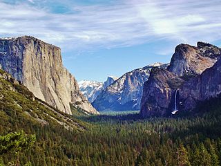
WYosemite Valley is a glacial valley in Yosemite National Park in the western Sierra Nevada mountains of Central California. The valley is about 7.5 miles (12 km) long and approximately 3000–3500 feet deep, surrounded by high granite summits such as Half Dome and El Capitan, and densely forested with pines. The valley is drained by the Merced River, and a multitude of streams and waterfalls flow into it, including Tenaya, Illilouette, Yosemite and Bridalveil Creeks. Yosemite Falls is the highest waterfall in North America and is a big attraction especially in the spring, when the water flow is at its peak. The valley is renowned for its natural environment and is regarded as the centerpiece of Yosemite National Park, attracting visitors from around the world.