 W
WThe Snake River is a major river of the greater Pacific Northwest region in the United States. At 1,078 miles (1,735 km) long, it is the largest tributary of the Columbia River, in turn the largest North American river that empties into the Pacific Ocean. The Snake River rises in western Wyoming, then flows through the Snake River Plain of southern Idaho, the rugged Hells Canyon on the Oregon–Idaho border and the rolling Palouse Hills of Washington, emptying into the Columbia River at the Tri-Cities, Washington.
 W
WThe Bonneville flood was a catastrophic flooding event in the last ice age, which involved massive amounts of water inundating parts of southern Idaho and eastern Washington along the course of the Snake River. Unlike the Missoula Floods, which also occurred during the same period in the Pacific Northwest, the Bonneville flood only happened once. The flood is believed to be the second largest in known geologic history.
 W
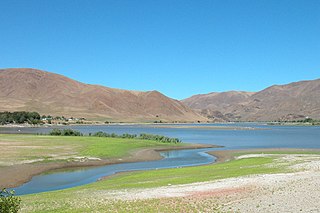
WLake Bonneville was the largest Late Pleistocene paleolake in the Great Basin of western North America. The Western Interior Seaway preceded Lake Bonneville. Lake Bonneville was a pluvial lake that formed in response to an increase in precipitation and a decrease in evaporation as a result of cooler temperatures. Lake Bonneville covered much of what is now western Utah and at its highest level extended into present-day Idaho and Nevada. Many other hydrographically closed basins in the Great Basin contained expanded lakes during the Late Pleistocene, including Lake Lahontan in northwestern Nevada.
 W
WCaldron Linn, or Cauldron Linn, also known as Star Falls, is a waterfall on the Snake River in southern Idaho.
 W
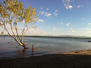
WThe Deer Flat National Wildlife Refuge is an important breeding area for mammals, birds, and other animals. The National Wildlife Refuge is located on land surrounding Lake Lowell, just outside Nampa, Idaho. It serves as a resting and wintering area for birds, including mallards and Canada geese, along the Pacific Flyway and was named a "Globally Important Bird Area" by the American Bird Conservancy.
 W
WFarewell Bend State Recreation Area is a state park in Baker County, Oregon, United States, about 25 miles (40 km) northwest of Ontario. Farewell Bend was the last stop on the Oregon Trail along the Snake River where travelers could rest and water and graze their animals before the trail turned north through more rugged country to follow the Burnt River.
 W
WHells Canyon is a 10-mile-wide (16 km) canyon located along the border of eastern Oregon, a small section of eastern Washington and western Idaho in the United States. It is part of the Hells Canyon National Recreation Area and is North America's deepest river gorge at 7,993 feet (2,436 m). Notably, Hells Canyon runs deeper than the better-known Grand Canyon.
 W
WLake Herbert G. West is a reservoir formed by the Lower Monumental Dam in the U.S. state of Washington. It extends up the Snake River for 28 miles (45 km) to the tailwater of Little Goose Dam. It has a surface area of 6,590 acres (27 km²), a maximum storage capacity of 432,000 acre feet (533,000,000 m3), normally kept at 377,000 acre feet (465,000,000 m3).
 W
WThe Marmes Rockshelter is an archaeological site first excavated in 1962, near Lyons Ferry Park and the confluence of the Snake and Palouse Rivers, in Franklin County, southeastern Washington. This rockshelter is remarkable in the level of preservation of organic materials, the depth of stratified deposits, and the apparent age of the associated Native American human remains. The site was discovered on the property of Roland Marmes, and was the site of the oldest human remains in North America at that time. In 1966, the site became, along with Chinook Point and the American and English Camps on San Juan Island, the first National Historic Landmarks listed in Washington. In 1969, the site was submerged in water when a levee protecting it from waters rising behind the then newly constructed Lower Monumental Dam, which was 20 miles (32 km) down the Snake River, failed to hold back water that leaked into the protected area through gravel under the soil, creating Lake Herbert G. West.
 W
WMassacre Rocks State Park is a history-focused public recreation area in the Northwest United States featuring the Massacre Rocks, a famous spot along the Oregon Trail and California Trail during the middle 19th century. The state park is located along the Snake River, ten miles (16 km) southwest of American Falls, in Power County, Idaho.
 W
WThe Minidoka Project is a series of public works by the U.S. Bureau of Reclamation to control the flow of the Snake River in Wyoming and Idaho, supplying irrigation water to farmlands in Idaho. One of the oldest Bureau of Reclamation projects in the United States, the project involves a series of dams and canals intended to store, regulate and distribute the waters of the Snake, with electric power generation as a byproduct. The water irrigates more than a million acres (4,000 km²) of otherwise arid land, producing much of Idaho's potato crop. Other crops include alfalfa, fruit and sugar beets. The primary irrigation district lies between Ashton in eastern Idaho and Bliss in the southwestern corner of the state. Five main reservoirs collect water, distributing it through 1,600 miles (2,600 km) of canals and 4,000 miles (6,400 km) of lateral distribution ditches.
 W
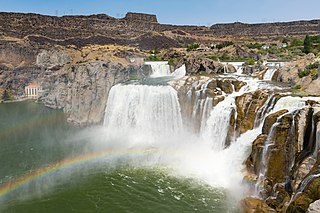
WShoshone Falls is a waterfall on the Snake River in southern Idaho, United States, approximately 3 miles (4.8 km) northeast of the city of Twin Falls. Sometimes called the "Niagara of the West," Shoshone Falls is 212 feet (65 m) high—45 feet (14 m) higher than Niagara Falls—and flows over a rim nearly 1,000 feet (300 m) wide.
 W
WSnake Indians is a collective name given to the Northern Paiute, Bannock, and Shoshone Native American tribes.
 W
WThe Snake River Archaeological District is an archaeological area located in Nez Perce County, Idaho, and Asotin County, Washington, and centered on the Snake River, which divides the two states. The area includes a number of sites inhabited by the Nez Perce people, who used it as a fishing ground and a winter campsite. Settlement in the area stretches from roughly 6000 B.C. to the 20th century A.D. Several hundred pictographs are part of the area, usually painted at village sites.
 W
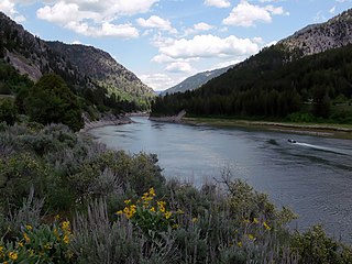
WThe Snake River Canyon is formed by the Snake River in western Wyoming, United States, south of Jackson Hole.
 W
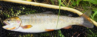
WThe Snake River fine-spotted cutthroat trout is a form of the cutthroat trout that is considered either as a separate subspecies O. c. behnkei, or as a variety of the Yellowstone cutthroat trout. The fish takes its common name from its original habitat, the Snake River of southern Idaho and western Wyoming, and from its unusual pattern of hundreds of small spots that cover most of its body, differing from the larger-spotted Yellowstone cutthroat pattern. Genetically, it cannot be distinguished from the Yellowstone cutthroat trout, and before the construction of dams, no physical barriers were between the ranges of the two subspecies in the Snake River drainage.
 W
WThe Snake River Plain is a geologic feature located primarily within the U.S. state of Idaho. It stretches about 400 miles (640 km) westward from northwest of the state of Wyoming to the Idaho-Oregon border. The plain is a wide, flat bow-shaped depression and covers about a quarter of Idaho. Three major volcanic buttes dot the plain east of Arco, the largest being Big Southern Butte.
 W
WThe Snake River Valley AVA is an American Viticultural Area that encompasses an area in Southwestern Idaho and two counties in eastern Oregon. The Idaho Grape Growers and Wine Producers Commission and the Idaho Department of Commerce and Labor filed the petition to recognize the AVA, and it was granted in 2007.
 W
WThousand Springs State Park is a public recreation and nature preservation area consisting of multiple units — Billingsley Creek, Earl M. Hardy Box Canyon Springs Nature Preserve, Malad Gorge, Niagara Springs, and Ritter Island — in Gooding County, Idaho.
 W
WThree Island Crossing State Park is a history-focused public recreation area in Glenns Ferry, Elmore County, Idaho, United States, that interprets the site of a ford of the Snake River on the Oregon Trail. The state park features camping, cabins, disk golf, and a visitors center with interpretive exhibits.
 W
WThe Tri-Cities are three closely linked cities at the confluence of the Yakima, Snake, and Columbia Rivers in the Columbia Basin of Eastern Washington. Each city borders one another, making the Tri-Cities seem like one uninterrupted mid-sized city. The three cities function as the center of the Tri-Cities metropolitan area, which consists of Benton and Franklin counties. The Tri-Cities urban area consists of the city of West Richland, the CDPs of West Pasco and Finley, as well as the CDP of Burbank, despite the latter being located in Walla Walla County.
 W
WTwin Falls is a waterfall on the Snake River in the Snake River Canyon in southern Idaho, United States. The falls are located on the border of Jerome and Twin Falls counties, a few miles east of its namesake city, Twin Falls. They are upstream of Pillar Falls and Shoshone Falls and just downstream from Milner Dam.
 W
WThe Utah chub is a cyprinid fish native to western North America, where it is abundant in the upper Snake River and throughout the Lake Bonneville basin.
 W
WThe Yellowstone Caldera is a volcanic caldera and supervolcano in Yellowstone National Park in the Western United States, sometimes referred to as the Yellowstone Supervolcano. The caldera and most of the park are located in the northwest corner of Wyoming. The major features of the caldera measure about 34 by 45 miles.