 W
WThe Hellsgate Wilderness is a 37,440-acre (151.5 km2) protected wilderness within the Tonto National Forest in Gila County, Arizona, at the base of the Mogollon Rim. It was created by the U.S. Congress in 1984 and is managed by the U.S. Forest Service.
 W
WThe Tonto National Forest, encompassing 2,873,200 acres, is the largest of the six national forests in Arizona and is the fifth largest national forest in the United States. The forest has diverse scenery, with elevations ranging from 1,400 feet in the Sonoran Desert to 7,400 feet in the ponderosa pine forests of the Mogollon Rim. The Tonto National Forest is also the most visited "urban" forest in the United States.
 W
WApache Lake is one of four reservoirs built along the Salt River in central Arizona as part of the Salt River Project.
 W
WBartlett Lake is a reservoir that was formed by the damming of the Verde River in the U.S. state of Arizona. It is downstream and to the south of Horseshoe Reservoir. Constructed in 1936–39 by the Salt River Project, the Bartlett Dam and reservoir were named for Bill Bartlett, a government surveyor. Bartlett Lake was the first reservoir built on the Verde River.
 W
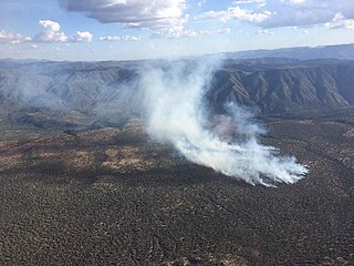
WThe Bush Fire was a human-caused wildfire that started in the Tonto National Forest northeast of Phoenix, Arizona. It burned 193,455 acres (78,288 ha). The fire started on June 13, 2020 near the intersection of Bush Highway and SR 87 and was fully contained on July 6, 2020
 W
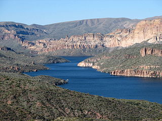
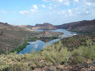
WCanyon Lake is one of four reservoirs that were formed by the damming of the Salt River in the U.S. state of Arizona.
 W
WThe Highline National Recreation Trail is a 54.7-mile trail that runs below the Mogollon Rim in the Tonto National Forest in Arizona. The trail showcases beautiful vistas of rim canyons, brushy hills, distant mountains, unique rock formations, and wonderful stands of Ponderosa pine. The trail was established in 1870 and was used to travel between homesteads and to attend school in Pine, Arizona. Zane Grey and Babe Haught used the Highline Trail while hunting, and the Zane Grey Highline Trail 50 Mile Run ultramarathon takes place on the trail. The portion of the Highline Trail from the Washington Park Trailhead to the Pine Trailhead is part of the Arizona Trail passage 26.
 W
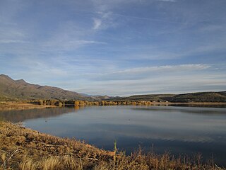
WHorseshoe Lake is a reservoir that was formed by the Horseshoe Dam on the Verde River in the U.S. state of Arizona. The lake and dam are located inside the Tonto National Forest is located upstream and north of Bartlett Lake. The dam is managed by the Salt River Project.
WMazatzal Wilderness is a wilderness area of about 390 square miles in Yavapai and Gila counties in the U.S. state of Arizona. The wilderness is within the Tonto and Coconino national forests. The town of Payson is to the east, and the Verde River is to the west. During summer, temperatures in the wilderness often exceed 110 °F.
 W
WThe New River Mountains are a small 14-mi (23 km) long, mountain range in central Arizona, and on the north border of the Phoenix valley; the range is located on the southwest perimeter of the Arizona transition zone. The range is a sub-part of landforms extending south from the Black Hills of Yavapai County. Rivers and canyons border east and west; the south of the range is located in Maricopa County, the location of much of the Phoenix metropolitan area.
 W
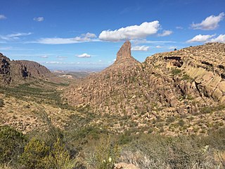
WPeralta Canyon is a canyon on the backside of Superstition Mountain within the Superstition Mountains. The canyon is a popular hiking destination within the Tonto National Forest and contains a single trail up the canyon to Fremont Saddle at the top of the canyon.
 W
WThe Polles Fire is a wildfire that burned in the Mazatzal Wilderness Area, 11 miles west of Payson, Arizona, in Tonto National Forest in the United States. The fire, which has burned 628 acres (254 ha), was started by a lightning strike during thunderstorms. The fire is burning in the along the Arizona Trail. As of July 15, it is 92 percent contained. The fire has resulted in the closure of the Tonto Natural Bridge State Park. On July 7, a helicopter working on the fire crashed, resulting in the death of pilot Bryan Boatman.
 W
WThe Rodeo–Chediski Fire was a wildfire that burned in east-central Arizona beginning on June 18, 2002, and was not controlled until July 7. It was the worst forest fire in Arizona's recorded history until June 14, 2011 when the Wallow Fire surpassed it. Several local communities, including Show Low, Pinetop-Lakeside, Heber-Overgaard Claysprings and Pinedale, were threatened and had to be evacuated.
 W
WSaguaro Lake is the fourth reservoir on the Salt River, formed by the Stewart Mountain Dam in the U.S. state of Arizona. The lake is off State Route 87, about halfway between Phoenix and the ghost town of Sunflower. The dammed end of the lake is at 33.5656°N 111.5361°W, at an elevation of 1,506 feet (459 m).
 W
WSalt River Canyon Wilderness is a 32,101 acres (12,991 ha) wilderness area located within the Tonto National Forest in the U.S. state of Arizona.
 W
WThe Shoofly Village Ruin is an archaeological site located in the Tonto National Forest near Payson, Arizona.
 W
WThe Sierra Ancha is a mountain range in Gila County, in central Arizona. It lies between Roosevelt Lake to the south, the Tonto Basin to the west, Cherry Creek to the east, and Pleasant Valley to the north. The range is one of several, including the Bradshaw Mountains, Mingus Mountain of the Black Hills, and the Mazatzal Mountains, which form a transitional zone between the lowland deserts of southern Arizona and the Colorado Plateau of northeastern Arizona. The highest point in the range is Aztec Peak, at an elevation of 2345 m (7694 ft).
 W
WSuperstition Mountain is located immediately east of the Phoenix metropolitan area in Arizona. It anchors the west end of the federally designated Superstition Wilderness Area. Although its precise origin is debated by geologists, many believe that the mountain was formed from volcanic activity approximately 25 million years ago. The ash and basalt composed mountain was eroded by the elements to give it the unique form it has today, creating the prominent landmark and popular recreation destination in the region.
 W
WThe Superstition Mountains is a range of mountains in Arizona located to the east of the Phoenix metropolitan area. They are anchored by Superstition Mountain, a large mountain that is a popular recreation destination for residents of the Phoenix, Arizona, area.
 W
WTheodore Roosevelt Lake is a large reservoir formed by Theodore Roosevelt Dam on the Salt River in Arizona as part of the Salt River Project (SRP). Located roughly 80 miles (130 km) northeast of Phoenix in the Salt River Valley, Theodore Roosevelt is the largest lake or reservoir located entirely within the state of Arizona. Both the reservoir and the masonry dam that created it, Roosevelt Dam, were named for U.S. President Theodore Roosevelt who dedicated the dam himself in March 1911. Roosevelt Lake is a popular recreation destination within the Tonto National Forest; the facilities located at this lake are managed by that authority.
 W
WTonto National Monument is a National Monument in the Superstition Mountains, in Gila County of central Arizona. The area lies on the northeastern edge of the Sonoran Desert ecoregion, an arid habitat with annual rainfall of about 16 inches (400 mm) here. The Salt River runs through this area, providing a rare, year-round source of water.
 W
WThe Verde River is a major tributary of the Salt River in the U.S. state of Arizona. It is about 170 miles (270 km) long and carries a mean flow of 602 cubic feet per second (17.0 m3/s) at its mouth. It is one of the largest perennial streams in Arizona.
 W
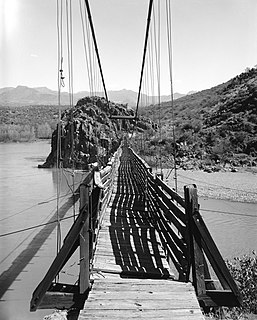
WThe Verde River Sheep Bridge, also known as the Red Point Sheep Bridge, is a suspension bridge which crosses the Verde River in Arizona. Constructed primarily to allow sheep to be driven between grazing ranges on either side of the river. Building started in 1943 and was completed in 1944. Sheep drives stopped in 1978. The bridge was closed in 1987 and largely demolished in 1988. A replica bridge was constructed in by the U.S. Forest Service in 1989 to allow hikers access to the Mazatzal Wilderness in Tonto National Forest. The original west suspension tower still remains alongside the replica bridge.
 W
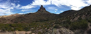
WWeavers Needle is a 1,000-foot-high (300 m) column of rock that forms a distinctive peak visible for many miles around. Located in the Superstition Mountains east of Phoenix, Arizona, Weavers Needle was created when a thick layer of tuff was heavily eroded, creating the spire as an erosional remnant with a summit elevation of 4,555 feet (1,388 m). It is set in a desert landscape of cactus and mesquite bush, with large Saguaro cacti particularly prominent. The peak was named after mountain man Pauline Weaver.